
The Indian Meteorological Department (IMD) argued that the formation of cyclone Asna (named by Pakistan) in August was rare. The rarity is mainly due to the influence of southwest monsoon which brings high wind shear to the atmosphere, detrimental to the development of a cyclone. Conditions are usually encouraging during pre and post-monsoon season which are May to June and October to December respectively. Hence, the presence of cyclone Asna in the Arabian Sea raised eyebrows.
According to the IMD, it was the first cyclone to form in this basin since 1976. The department states that the 1976 storm originated over the Bay of Bengal near the Odisha coast emerged over the Arabian Sea as a cyclone and made a loop before moving towards Oman (Link).
Upon browsing various sites, there was a storm that matched the description presented by the IMD in August. Classified as cyclone 06B, it formed on August 27 and dissipated on September 9. However, we found that there is a notable discrepancy in the narrative that it’s the first cyclone since 1976.
Scale used by IMD to categorize the storm
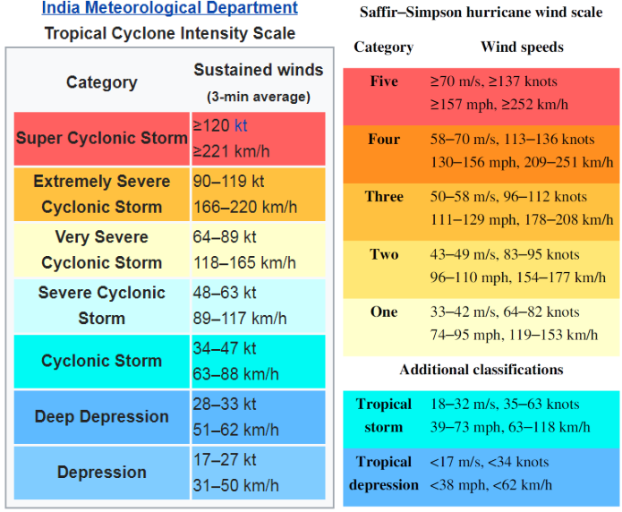
The assertion made by the IMD regarding 1976 is based on the Saffir-Simpson Hurricane Wind Scale (SSHWS). The SSHWS is a scale primarily used in the Atlantic Ocean and the northeastern Pacific Ocean to classify hurricane categories. It is used by the National Hurricane Center in the United States and is also unofficially used by the Joint Typhoon Warning Center (JTWC), a joint effort of the U.S. Navy that monitors global tropical cyclones.
On the other hand, the IMD follows its own scale, which is also applied by South Asian and some Middle Eastern countries to gauge the strength of tropical systems. Both scales have distinct wind speed criteria and classifications. Once a storm reaches the status of a ‘cyclonic storm’ in the North Indian Ocean, it is designated a name. A ‘cyclonic storm’ on the IMD scale is roughly equivalent to a ‘tropical storm’ on the SSHWS scale, as indicated by the color coding.”
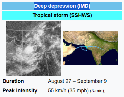
Exploring the events of 1976, one can observe that it is classified as a deep depression (as shown in the above picture) on the IMD scale, not a cyclone. Hence, it is somewhat perplexing why the department has declared it a cyclone now.
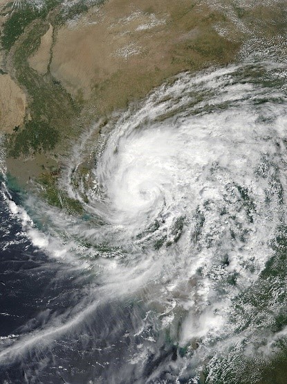
The most recent Arabian Sea cyclone to have formed in August
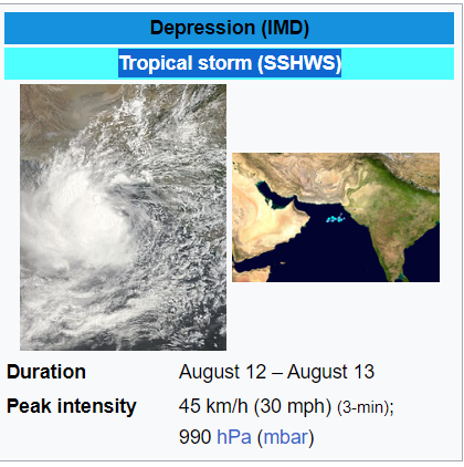
If we categorize storms based on the SSHWS scale, a cyclone occurred recently in the Arabian Sea in August (as shown in the above picture). According to the JTWC, a cyclone formed in early August in 2022 approximately south-southwest of Karachi and was designated as 03A, see below.
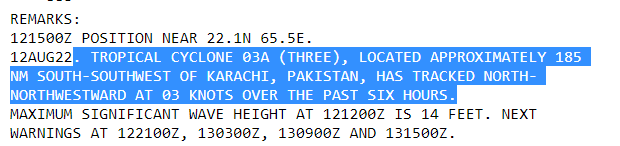
which PWP followed and highlighted in their daily X (Twitter) posts in 2022. However, a typo in our tweets resulted in it being named 02A.

Is the development of depressions over land a rare event?

While not a very common occurrence, it is not unheard of for low-pressure systems to attain “depression” or “deep depression” status over land in our region. They are classified as “Land” due to their formation over a land. The most recent example (as shown in the above picture) was during the first week of August 2024, when a system named “Land 01” intensified into “deep depression” and traveled across much of India.
What about the area where Asna recently formed?
Focusing specifically on southwestern India, such as Gujarat and Rajasthan, where the pre-cyclonic state of Asna existed as a “deep depression”, depressions have indeed formed in this region in the recent past. A depression formed on September 30, 2019 (as shown in the above picture), in this particular area and eventually exhibited an eye.
Related post
- Read about cyclone Gulab-Shaheen, a similar cyclone that developed during the active monsoon season in September of 2021 and took a similar route. Gulab was also named by Pakistan.
Powerful Arabian Sea Cyclones since 1998
Here is a list of powerful tropical cyclones that have formed in Arabian Sea since 1998 on the basis of SSHWS scale;
- Super Cyclone Gonu, a category-5 hurricane. Windspeed: 165 mph (2007)
- Super Cyclone Kyarr, a category-4 hurricane. Windspeed: 155 mph (2019)
- Cyclone Chapala, a category-4 hurricane. Windspeed: 150 mph (2015)
- Cyclone Phet, a category-4 hurricane. Windspeed: 145 mph (2010)
- Cyclone Tauktae, a category-4 hurricane. Windspeed: 140 mph (2021)
- Cyclone Nilofar, a category-4 hurricane. Windspeed: 130 mph (2014)
- Cyclone ‘2001’, a category-3 hurricane. Windspeed: 130 mph
- Cyclone Megh, a category-3 hurricane. Windspeed: 125 mph (2015)
- Cyclone Gujarat ‘1998’, Cyclone Keti ‘1999’ (Strongest Cyclone to affect Pakistan), and Cyclone Biparjoy (2023), all were category-3 hurricanes. Windspeed: 120 mph.
- Cyclone Ockhi (2017), Cyclone Mekunu (2018), Cyclone Vayu (2019), Cyclone Maha (2019), Cyclone Gati (2020), all were category-3 hurricanes. Windspeed: 115 mph
- Cyclone Hika (2019), category-2. Windspeed: 105 mph.
- Cyclone Luban, category-2 hurricane. Windspeed: 100 mph
