-
Hottest Month is not so hot!
-
Dry month to become wet?
-
Early Pre-Monsoon this year?
It has been noted that El-Nino usually causes an increase in the number of Western disturbances. The country has been witnessing continuous local thunderstorms formation since April that is keeping the temperature on the lower side although an El-Nino year is usually hotter than average. So far Pakistan only witnessed two heatwaves, one during the last week of April that was relatively strong and longer while the second one in early May was short and weak. May is the hottest month in the country although at this moment it has been less hotter than average. The heating trend might continue after the middle of May.
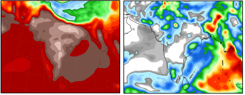
According to the above picture, eastern parts of Pakistan are witnessing above 38° temperature while few pockets of central Sindh are witnessing 40°C temperature. The precipitation image shows 99.9% Pakistan under the influence of thunderstorms which is very rare in the month and that too from western disturbance though Arabian sea’s moisture would play an important as well.
Widespread rains at the door – Slight possibility of Pre-monsoon!

WARNING: Authorities should be on alert as uncertain weather is expected in the upcoming week. Possibility of urban flooding in upper KPK and Azad Kashmir. Damaging windstorms cannot be ruled out!
May usually witness isolated rains with strong dust storms but this May can turn out to be a rare one as widespread thunderstorm formation is expected. PWP Facebook on May 4 had stated that according to few numerical models heavy moisture build-up might be observed over Pakistan and adjoining western India during the middle of May, this moisture might be a result of western winds and Arabian sea’s moisture. On May 5, PWP did say that there ‘can’ be a east to west thundercloud movement during that week.
According to the Indian Meteorological Department (IMD), an upper air cyclonic circulation over central Madya Pradesh has moved in a West direction, now this is significant move as such movement usually happen in the month of June which indicates pre-monsoon activity whether this UAC would have enough strength to merge with the western low pressure or it would cause thunderclouds to move into south Punjab and central areas of Pakistan is yet to be seen though both of these possibilities exist.

Rain/Hail with thunder/lightning accompained by strong gusty winds (<80 km/h) might start from May 11 night in some north-western areas of the country and continue throughout the week with intervals. Heavy downpour might occur in Azad Kashmir and northern Khyber Pakhtunkhwa (Kohistan, Naran, Mansehre, Battagram, Shangla, Abbottabad and few adjoining areas), heavy rain can also occur in Islamabad. Strong possibility of rain with chances of isolated heavy rain in Lahore on May 12/May 13 and surrounding areas. This unusual activity might also cause moderate to isolated heavy rain in central and southern areas (especially Lower Balochistan and adjoining Sindh) of the country. Chances of light to medium intensity rain with strong winds in Karachi on May 15/May 16. There is a good probability that central areas of Pakistan (south Punjab) might experience some pre-monsoon activity due to the western-eastern interaction that might result in a east to west bound thunderclouds from May 15/May 16.
Tropical activity expected in June?

On May 4, PWP Facebook said that “Another model (CFS) shows another tropical depression in central Arabian sea, it’s track is disputed”.
Now the same model shows that tropical depression moving towards coastal Sindh in June during the second week. Though it is early to trust this track.
Poll of the week
Following is a question from Pakistan Weather Portal (PWP);
The Portal’s forecast what happened and what did not!
The main features of the PWP’s forecast are discussed below. Overall the prediction went good.
1. Predicted: Possibility of urban flooding in upper KPK (Kohistan, Naran, Mansehre, Battagram, Shangla, Abbottabad and few adjoining areas) and Azad Kashmir. Reality: Authorities are now on high alert in Shangla after overnight heavy rains have caused mid level flood in the rivers.
2. Predicted: Damaging windstorms cannot be ruled out. Reality: High winds and lightning resulted in the death of 14 people across Pakistan while 40 were injured.
3. Predicted: Heavy rain can also occur in Islamabad. Strong possibility of rain with chances of isolated heavy rain in Lahore on May 12/May 13 and surrounding areas.Reality: Moderately heavy rain occurred in Islamabad on May 13 as 43 mm rain was recorded. Rain occurred in Lahore on May 13 though was not heavy as 15 mm was recorded.
4. Predicted: There is a good probability that central areas of Pakistan (south Punjab) might experience some pre-monsoon activity due to the western-eastern interaction that might result in a east to west bound thunderclouds from May 15/May 16. Reality: West and east interaction did occur as UAC was over NW Rajasthan though it did not cause east to west thunderclouds. From May 16 till May 17, 65.4 mm rain fell in Multan while 30.5 rain fell in Bahawalpur.
5. Predicted: This unusual activity might also cause moderate to isolated heavy rain in central and southern areas (especially Lower Balochistan and adjoining Sindh) of the country. Reality: 33 mm rain fell in Lasbella city of lower Balochistan while adjoining Sindh (Dadu got 40 mm) got good rain.
6. Predicted: Chances of light to medium intensity rain with strong winds in Karachi on May 15/May 16. Reality: Light rain with brief moderate falls along with dusty winds occurred earlier than expected that was May 14 and again on May 15 morning. 1 mm rain was recorded in the city.
