
Monsoon to end with a 𝘎𝘶𝘭𝘢𝘣𝘪 touch?
The presence of Cyclone ‘Gulab’, meaning Rose in Urdu, has puzzled many International and local weather forecasters. No computer model or simulation was able to foresee this storm. What makes this cyclone abnormal is that it has formed during the monsoon season. Due to high wind shear and relatively calm sea surface temperatures, tropical storms are rare from July to September. Commonly, such storms form in the North Indian Ocean during the pre-monsoon (April-June) and the post-monsoon phase (October-November). Alternatively, the Indian Meteorological Department (IMD) claims that since 1891 a total of 45 tropical cyclones have developed in September. However, experts have questioned the credibility of IMD’s data. Viable date released by University of Reading in the UK shows that tropical cyclones in the monsoon season is not unusual as we thought. They do form but are rare. From 1975 to 2020, there have been six tropical storms from the Bay of Bengal in September, four in August, two in July (all during the monsoon season). Whereas, five have formed in the Arabian Sea, the second sector of the North Indian Ocean.
Wettest cyclones/depressions in Pakistan
Below is the highest rainfall by a cyclone or depression in Pakistan*;
- In 2010, Cyclone Phet caused 370 mm rain in Gwadar. 150 mm rain was recorded in Karachi.
- In 1999, Cyclone Keti (unofficial name given by locals) caused 285 mm rain in Keti Bandar.
- In 2009, remnants of a tropical depression from the Bay of Bengal caused 225 mm – 245 mm rain in Karachi in July.
- In 2007, Cyclone Yemyin caused 110 mm rain in Karachi.
- In 2004, Cyclone Onil caused 145 mm rain in Thatta while 98 mm rain in Hyderabad. It caused 39.3 mm rain in 48 hours in Karachi. 26.5 mm is currently the record 24-hour rain in Karachi in the month of October which was also caused by Onil.
*These records and rain stats are by the PAK MET OFFICE.
Monsoon Cyclones in recent years
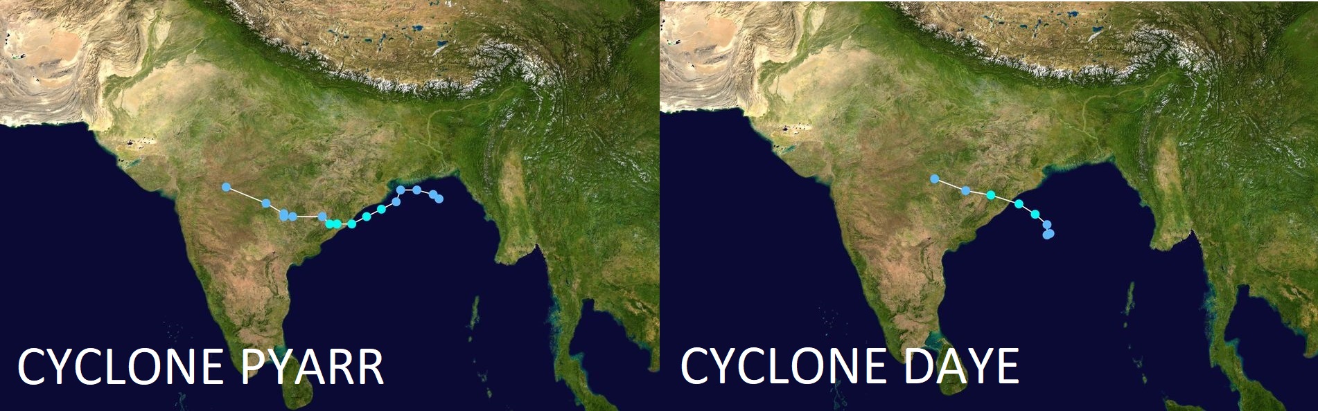
Two tropical cyclones have formed in the Bay of Bengal since 2000 in September. Cyclone Pyarr (2005) and Cyclone Daye (2018), both had identical time frame, track and intensity. No impact on Karachi was observed except for a change in wind direction for few days by Pyarr.
One tropical cyclone formed in the Arabian Sea during the monsoon season. In 2019, Cyclone Hikaa formed off the coast of western India and made landfall over Oman. It was a category-2 hurricane. It left moisture for another low pressure over Gujarat-Rajasthan that caused heavy stormy rain in Karachi on September 27, 2019. According to the data of IMD, monsoon withdrew on October 9 making it the longest season in the region, making Hikaa a monsoon cyclone. Below is the track of Cyclone Hikaa.

Bay of Bengal depressions that gained equivalent or further strength in the Arabian Sea
Monsoon low pressures or depressions from the Bay of Bengal do usually emerge as low pressure or circulations off the coast of Gujarat and Sindh in the Arabian Sea, these systems commonly cause rains in Karachi from July to September. However, the documented cases of Bay of Bengal depressions or cyclones crossing into the Arabian sea only to re-intensify at an equivalent strength are not as common. Below are few notable mentions;
- In November 2000, category-1 hurricane crossed the Bay of Bengal from southern India into the Arabian Sea, the remnants reached as far as the Horn of Africa.
- Again in November 2000, another category-1 hurricane made landfall in Sri Lanka and emerged briefly as a cyclonic storm in the Arabian Sea to make a second landfall over Tamil Nadu.
- In 2004, Cyclone Agni formed as a tropical depression in the southern Bay of Bengal and reached cyclonic storm status in the Arabian Sea. It made landfall in Somalia.
- In June 2007, Cyclone Yemyin formed as a tropical depression in the central Bay of Bengal crossed mainland India into the Arabian Sea. It gained “tropical storm” status and made landfall at Makran coast.
- In August 2007, a deep tropical depression formed in the Bay of Bengal and re-intensified into a deep depression off the coast of Pakistan in the Arabian Sea as per PMD although IMD disputes this claim.
- In November 2010, Cyclone Jal formed in the Bay of Bengal and made landfall over eastern India. It later emerged in the Arabian Sea and moved into Gujarat as a high-end well-marked low pressure/weak depression.
- In 2016, Cyclone Vardah, a category 2 hurricane, formed in the Bay of Bengal and made landfall over southern India. It crossed into the Arabian Sea and made a second landfall as a tropical depression in Somalia.
- In 2017, remnants of Pacific Ocean’s tropical storm ‘Kirogi’ crossed into the North Indian Ocean in the Bay of Bengal. The remnants continued to move into the Arabian Sea and strengthened into cyclone ‘Ockhi’. It dissipated off the coast of west India.
- In 2018, Cyclone ‘Gaja’, a category-1 hurricane formed in the central Bay of Bengal and made landfall over southern India, it maintained its cyclonic status and emerged in the Arabian sea as a cyclone. It gradually weakened and moved into Horn of Africa.
Name change of the storm if it regains cyclonic strength
If the remnants of Gulab re-intensify into a cyclone, will it be #CycloneShaheen or #CycloneGulab? Both basins (the Arabian Sea & the Bay of Bengal) come under the RSMC, technically it should be Gulab as the system and the Ocean is the same. IMD does tend to change the way of naming storms from time to time;
1. Deep depression (Yemyin) “BOB03” was still called BOB03 when it entered the Arabian Sea.
2. Cyclone Vardah (IMD initial BOB06) was given new initials i.e ARB02 when crossed into the Arabian Sea.
3. Cyclone Gaja retained its name when it moved into the Arabian Sea.
4. Majority of the Indian media has started calling Gulab as Shaheen.
5. Foreign tropical observers are still calling it “03B/remnant Gulab”
In its PR on September 29, IMD has confirmed that the regeneration of Gulab will be known as cyclone Shaheen, if it happens.
Daily Tropical Coverage of Cyclone Gulab/Shaheen

Cyclone Gulab – This makes Gulab as the fourth monsoon cyclone of September since 2000 in the North Indian Ocean. On the other hand, it is the third tropical storm of the current year.
Cyclone Shaheen – This makes Shaheen as the fifth monsoon cyclone of September since 2000 in the North Indian Ocean. Second in the Arabian Sea. On the other hand, it is the fourth tropical storm of the current year. It could be confusing even though its the same storm! A new name should not have been given. The name was suggested by Qatar, meaning ‘Falcon’
Update of October 2 – 5:15 PM
Heavy/torrential downpours lashes Gwadar district with stormy conditions, should subside by tomorrow night
- SIX FACTS
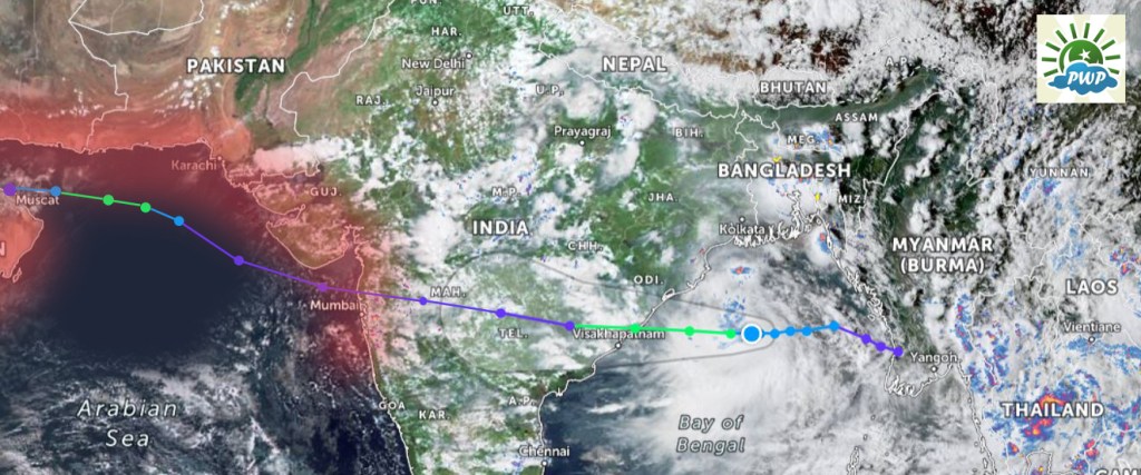
- Cyclone Shaheen-Gulab started its journey as a mass of clouds over Myanmar in the Bay of Bengal to reach Pakistan in the Arabian Sea as a new cyclone and it could now enter Saudi Arabia as a remnant low pressure after either making landfall over Oman or moving into the Persian Gulf. Its journey lasted a distance of more than 4,000 km from Myanmar to the Arabian Penninsula, one of the longest distance covered by a tropical system in the north Indian Ocean.
- It is the only cyclone in the North Indian Ocean to be re-named. (Check the ‘Name change of the storm section’).
- In 11 years, Shaheen-Gulab is the strongest tropical storm making its closet approach to Pakistani coastline since cyclone Phet. Cyclone Keti of 1999 retains the record as a category-3 hurricane.
- Only the third cyclone in recent history to venture into the Gulf of Oman after cyclone Phet (2010) and super cyclone Gonu (2007).
- Only the second cyclone in documented history to intensify in the Gulf of Oman after Gonu.
- Cyclone Shaheen-Gulab might have broken the rain record set by cyclone Onil for Karachi in October 2004, details below.
Cyclone ‘Shaheen’ intensified into a category-1 hurricane and made its closest approach to Gwadar at a range of 106.4 S/SW from the city (within our estimates of 80 km to 120 km). While as a deep tropical depression at 196.7 km S of Karachi (also within our forecasted range of 140 km to 200 km) in the early hours of Oct 1. The track the storm is following is relatively similar to what PWP issued on September 25. It is causing heavy at times torrential downpour with gusty winds in Gwadar district. More occasional heavy rain is expected till tomorrow night especially Gwadar city and Jiwani (more than 50 mm has been recorded so far in 24 hours). Watch for thunderstorms/more occasional heavy rain till tomorrow evening/night as it makes landfall over Oman on Sunday which could cause the storm to start disintegrating thus cloud mass will expand.
It is worth-mentioning that cyclone Shaheen-Gulab has broken Cyclone Onil record for the wettest October in Karachi. As per the data released by Pak Met Office;
- 48 hours rainfall by Cyclone Onil was 39.3 mm. 24 hour rain was 26.5 mm on October 3, 2004
- 48 hours rainfall by Shaheen/Gulab is 62 mm. 24 hour rain is 39 mm on October 1.
There is some dispute as one historical data highlights 1959 as the wettest October however the new data of PMD points towards 2004 October as the wettest October in Karachi. If true then there is no reason to question that cyclone Shaheen-Gulab has broken the record. Since it is now moving away from the Pakistani coast and waters therefore this is our last update for cyclone Shaheen-Gulab.
Update of October 1 – 3 PM
Shaheen/Gulab now moving on almost the same location from where cyclone Phet was approaching in 2010


- THREE FACTS
- Monsoon Overview 2021: Cyclone Shaheen has broken the record for the longest monsoon season in Karachi. The previous record was on September 29 in 2019 (Heavy stormy downpour occurred on September 27. 2019). This year the monsoon will start to withdraw from the city on October 2-3.
- September Insights: Record total Monthly rain of September: 166.4 mm (1961), 315.7 mm (1959), 421.3 (2021), Record 24-hour rain of September: 101.3 mm (1962) and 140 mm (2011). Average normal of September: 11 mm. 14.5 mm (2021)
- October Analysis: The “highest 24-hour rainfall” in the month of October is only 26.5 mm set by Cyclone Onil recorded on October 3, 2004 in Karachi. Cyclone Shaheen/Gulab had a very good potential to break it.
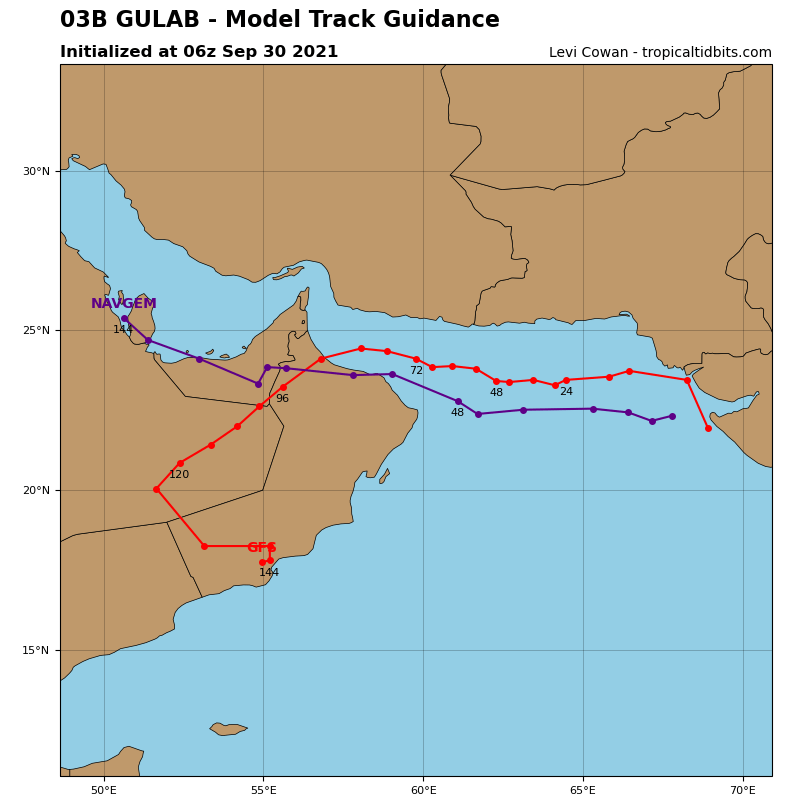
Yesterday’s tropical depression (remnants of cyclone Gulab) re-intensified into a deep tropical depression and then further into Cyclone ‘Shaheen’ in the Arabian Sea. It is 310 km SSW of Karachi. ‘Shaheen’ is likely to become a category-1 hurricane as it now moves in a W direction. It will advance near the Makran coast (Pakistan) before curving to make landfall over Oman or it can even spin into the Persian Gulf.
Cyclone Shaheen and the 5th Monsoon Spell nearing its end for Karachi
The reason behind the lack of high precipitation thunderstorms in the city explained
As per our yesterday’s update, we estimated that the storm will reach within the range of 140 km to 200 km from Karachi, the closest approach it did last night was 196.7 km SSE of Karachi (well-within our estimates). Please be advised that the storm was never expected to make landfall in Karachi (please check the estimated map that was issued by PWP on September 25). Winds did reach within the predicted range at 40 mph to 43.4 mph (highest recorded in Karachi at our station).
Since tropical systems have cone of uncertainty, our focus was on the outer bands and given the close proximity of the system to the coast and conclusive agreement by all numerical models, we issued a ‘heavy rain with isolated heavy downpour’ watch coupled with urban flooding and gusty winds (40 mph to 50 mph) for Karachi at a probability of 65%. The possibility was high from Thursday night till Friday. However, the rain that fell was far below expectation – only at 39 mm. So what happened? the atmospheric flow on which tropical systems move slowed down when the depression was 209.7 km SSE of Karachi. The speed dropped from 23 kmph to 13 kmph, allowing it to gain intensity much quickly. In tropical systems thunderstorms are tightly concentrated towards the core, the more the system intensifies, the more tightly the thunderstorms get embedded around the center. As the system started gaining momentum much earlier than expected in the SSE of the city, the thunderstorm remained off the coast of Karachi and in the east. It was expected to intensify SSW of the city, not SSE. The track also slightly altered from WNW to W but had it maintained its well-marked low pressure/depression status, there would have more activity. We did get a glimpse of its power when the storm made its closest approach to the city at 196.7 km on the early hours of October 1.
Where does Shaheen go from here? The outer bands continues to affect Karachi as the storm moves towards Makran, therefore there can still be few heavy rainfall till afternoon/evening. It should completely move away by Friday evening. As we stated that we will only downgrade the chances once it moves away from the coast therefore following conditions are expected from Friday evening;
- Drizzle to showers (few sharp) with windy conditions from evening/tonight. Few southern and south-western can get moderate rain till Friday night. No chance of heavy rain from Friday evening as significant decrease is being observed.
Cyclone Shaheen and the coast of Balochistan
Estimating the closest approach of Cyclone Shaheen as a strong category-1 hurricane to Gwadar city within the range of 80 km to 120 km.
Cyclone Shaheen will be passing near the Makran coast as a high-end tropical storm and later a category-1 hurricane. Given its closeness to the coast and cone of uncertainty, watch for possible torrential rains/gusty winds is now in-effect over the Gwadar district (Gwadar city, Jiwani, Pasni and adjoining Orama). Once it makes landfall over Oman, the thunderstorms will start spreading as the core will weaken. These thunderstorms can especially impact Jiwani and Gwadar city. Under the influence of Shaheen;
- Very heavy to isolated extremely heavy rain (chance at 65%) on Oct 1 night/Oct 2. Watch for stormy winds ranging from 40 to 50 mph. Sea conditions will be rough during this period.
……………………………………………………………………………………….
Update of September 30 – 6 PM
Torrential downpours/gusty winds cannot be ruled out as long as the storm is present in Pakistani waters

FACT: First time since 2010, a tropical depression has come this close to Karachi. Nearest approach of tropical depression (would-be-cyclone Yemyin) was 95 km SW of Khi. 2. Nearest approach of tropical depression (ex-cyclone Phet) was 50 km E of Khi.
Yesterday’s well-marked low pressure (remnant of cyclone Gulab) and now lies over north-east Arabian Sea. It is 225 km SE of Karachi city and has entered Pakistani territorial waters. Wind gust of 43.4 mph (69.8 kmph) from NE/ENE was reported at our station today (south Karachi) with light to sharp showers. So far the highest wind speed for today! The storm continues to move in a W/WNW direction. As expected, it has intensified into a tropical depression with clear ‘tropical system rotatory’ features and a weak eye wall. Due to favorable SST conditions (28°C to 29°C) in the north-eastern Arabian and adjoining Pakistan coast along with low vertical wind shear, the depression will intensify further into a strong tropical depression or even into a cyclonic storm in the coming 6 to 24 hours. Hence we have increased the probability of it intensifying into a tropical storm from ‘45%’ to ‘50%’.
According to our rough estimates, the closest approach of tropical depression to Karachi would range from 140 km to around 200 km. Due to its ‘close proximity’ to Sindh’s coast, we cannot rule out torrential rains/gusty winds throughout today/tomorrow. From Friday evening, it will start to move away from Karachi. Therefore the watch remains intact;
- Heavy rain with isolated very heavy rainfalls (chance at 65%) on Sept 30/Oct 1 (+1 day error) in lower Sindh especially coastal Sindh including Karachi. Watch for stormy winds ranging from 40 to 50 mph. Sea conditions will be rough during this period. Watch for city-wide flooding especially the southern areas of Karachi (DHA, Clifton, Saddar and adjoining areas).
- Very heavy to isolated extremely heavy rain can occur at Makran coast in Balochistan as well (chance upgraded at 65%) on Sept 30/Oct 1/Oct 2. Watch for stormy winds ranging from 40 to 50 mph. Sea conditions will be rough during this period.
The intensity of the downpours depends on the track which will keep changing but since it is moving into Pakistani waters therefore its thunderstorms and outer bands have a high possibility of affecting the coastline of the country. Chances will be downgraded once it moves away. A landfall was never expected at least in Sindh.
……………………………………………………………………………………….
Update of September 29 – 7 PM
All numerical models continue to point towards severe thunderstorms near/over Pakistani coastline.

FACT: Gulab closely resembles Cyclone Yemyin (2007). Both storms originated in the Bay of Bengal and moved into W/WNW direction over India towards Pakistani coast. While future ‘Yemyin’ was a depression in the Bay and gained tropical storm status in the Arabian Sea. Gulab had tropical storm status in the Bay and could gain it again in the Arabian Sea.
Well-marked low pressure ‘Gulab’ has maintained its intensity and it has started advancing rather fast and now lies over Saurashtra (Gujarat). Sindh province of Pakistan especially lower areas (Tharparkar, Badin and Thatta district) are now under the influence of this system as thunderstorm formation is taking place. As predicted, Karachi reported another hot day at 38°C with warm winds due to change in air flow by the approaching system.
‘Gulab’ is likely to move in W/WNW direction towards the Pakistani waters with re-intensification (upgraded to 85% chances) into a tropical depression in the next 12 to 14 hours. A ‘Watch’ for tropical storm (cyclonic storm) formation has been issued by the South Asian Tropical Department as well as by the Joint Typhoon Warning Center. We are maintaining the development of a tropical cyclone at 45% for the time now on Thursday evening/Friday morning. IMD will re-name it to cyclone Shaheen if it re-gains tropical storm strength. Due to this storm, we have upgraded the chance of rain at Makran coast further;
- Heavy rain with isolated very heavy rainfalls (chance at 65%) on Sept 30/Oct 1 (+1,-1 day error) in lower Sindh especially coastal Sindh including Karachi. Watch for stormy winds ranging from 40 to 50 mph. Sea conditions will be rough during this period. Watch for city-wide flooding especially the southern areas of Karachi (DHA, Clifton, Saddar and adjoining areas)
- Very heavy to isolated extremely heavy rain can occur at Makran coast in Balochistan as well (chance upgraded at 65%) on Sept 30/Oct 1/Oct 2. Watch for stormy winds ranging from 40 to 50 mph. Sea conditions will be rough during this period.
The duration of the system has slightly changed as ‘Gulab’ is now moving much faster than expected. The intensity of the downpours depends on the track which will keep changing but its very likely that the storm will move over the Pakistani waters with its thunderstorms affecting the coastline of the country therefore the watch for torrential rain/stormy conditions is valid until the storm moves away from the Pakistani territory.

Second system over the Bay of Bengal has moved in-land as a significant weather system. International observers argue that it was a tropical depression, IMD has not declared so. Given its windspeed along with clear counter-close wise movement, we believe it was a depression. No impact to Pakistan from this system.
……………………………………………………………………………………….
Update of September 28 – 9 PM
–5th Monsoon spell of September
Coastal areas of Pakistan should gear-up for the heaviest rain of this year as the threat of Gulab looms
Well marked low pressure ‘Gulab’ lies over Maharashtra-Vidarbha, it continues to bring more than 50-200 mm rain in its path. It is very likely to move further into Maharashtra and adjoining Gujarat as a low pressure area in the next 24 to 36 hours. After 48 hours, there is a possibility (75%) of re-intensification into well-marked low/depression. Watch for tropical storm formation (chance at 45%) on Thursday night/Friday. Under the influence, we have upgraded the chances of rain for southern Pakistan;
- Heavy rain with isolated very heavy rainfalls (chance at 65%) on Sept 29/Sept 30/Oct 1 (+1,-1 day error) in lower Sindh especially coastal Sindh including Karachi. Watch for stormy winds ranging from 40 to 50 mph. Sea conditions will be rough during this period. Watch for city-wide flooding especially the southern areas of Karachi (DHA, Clifton, Saddar and adjoining areas)
- Very heavy to isolated extremely heavy rain can occur at Makran coast in Balochistan as well (chance at 55%) on Sept 30/Oct 1/Oct 2. Watch for stormy winds ranging from 40 to 50 mph. Sea conditions will be rough during this period.
- On Wednesday, the temperature can hover around 37°C to 39°C (feel like can be 39°C to 41°C) in Karachi.
Since it is the monsoon season, the storm (any weather system at a stage of depression or above is a storm) will bring thunderstorms to coastal Pakistan irrespective of its trajectory as the moisture level are quite high and conditions are favorable for thunderstorm formation. The intensity of downpours depends on the path. A new strong monsoon low pressure has formed in the Bay of Bengal as well.
……………………………………………………………………………………….
-4th Monsoon spell of September
100 mm rain recorded in Chorr in Sindh, isolated thunderstorms reported from Karachi
As per the forecast of PWP, hit-or-miss thunderstorms were reported. Even right now there are bulk of thunderstorms over the province with little to no precipitation. Few thunderstorms brought high level or rains. High temperature was observed in Karachi as predicted by us. As of now, circulations over central India & adjoining Rajasthan and north-east Arabian sea have merged with the upcoming Gulab, so technically this does mean the end of the 4th spell and gradual shift towards the 5th spell has started.
……………………………………………………………………………………….
Update of September 27 – 8 PM
4 mm rain recorded in Karachi as the 4th spell hits the city, more hit-or-miss thunderstorms can happen.
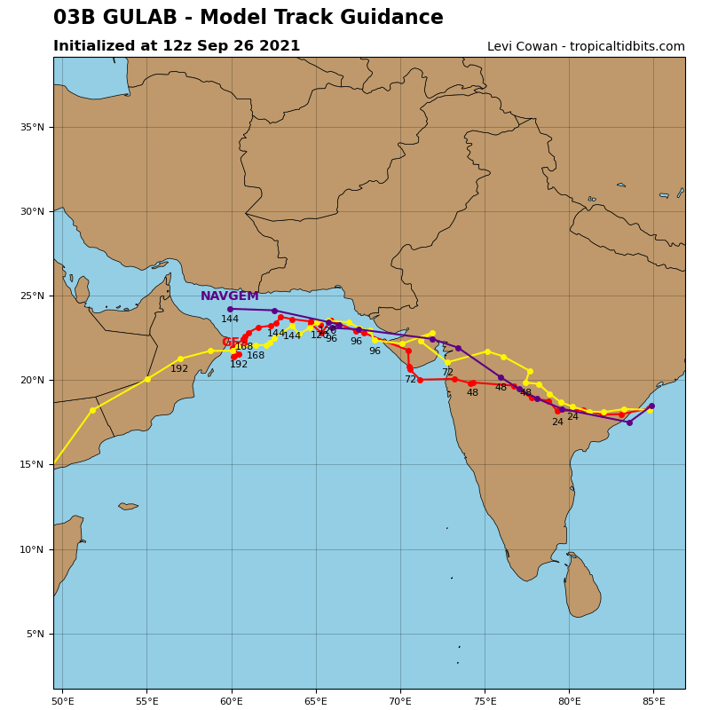
Due to land interaction, cyclone Gulab has weakened into a depression and lies over Telangana-Chhattisgarh, in the next few hours it will weaken further into a well-marked low pressure and move into Maharashtra. The city of Visakhapatnam in Andhra Pradesh has broken its 16-year-old record. Due to #CycloneGulab, 282 mm rainfall is recorded in 24 hours, the previous record was 194 mm in 2005. The storm is advancing rather quickly. All numerical models continue to show the emergence of this system in the Arabian Sea as a well-marked low pressure or a depression with a watch for re-intensification. Forecast issued on September 27 – 3 AM is valid.
……………………………………………………………………………………….
Update of September 27 – 3 AM

Cyclone Gulab is presently located 30 KM west of Kalingapatnam in Andhra Pradesh. It is in the process of completing its landfall.
- Windspeed: 45 mph gusting to 70 mph
- Direction: West
– 4th Monsoon Spell of September in South Pakistan – A low pressure is over central India which has stalled due to the Fujiwara effect being caused by Cyclone Gulab. A circulation lies over north-east Arabian Sea (remnants of depression BOB03) which has created a corridor of moisture to travel from central India to Gujarat and adjoining Sindh. Dry air has further weakened in Balochistan. As the Monsoon axis is southwards and under the influence of low pressure over central India;
- Hit-or-miss thunderstorms (chance at 50%) in SE, Lower and coastal Sindh including Karachi on Sept 28 (-1,+1 day error)
- From Monday to Wednesday, temperature can reach as far as 37°C to 39°C (feel like can be 39°C to 41°C) in Karachi
- Due to fragile infrastructure of the city, watch for urban flooding.
– 5th* Monsoon Spell of September in South Pakistan (Cyclone Gulab) – Almost all numerical models show that Cyclone Gulab will emerge as a well-marked low pressure or a depression in the Arabian Sea, near the coast of Mumbai. It is expected to travel west and there will be a watch for re-intensification.
*If the 4th Spell doesn’t happen then the 5th spell will be called the 4th spell

Under the influence of Cyclone Gulab;
- Heavy rain with isolated very heavy rainfalls (chance at 55%) on Sept 29/Sept 30/Oct 1 (+1,-1 day error) in lower Sindh especially coastal Sindh including Karachi. Very heavy to isolated extremely heavy rain can occur at Makran coast in Balochistan as well (chance at 45%).
- Watch for stormy winds ranging from 40 to 50 mph.
- Sea conditions will be rough during this period.
- Watch for urban flooding.
We will update our readers if the forecast or track changes.
For more cyclone-related articles

Babar Bhai, very impressed. Highly accurate predictions and forecasting of fourth and fifth spell.
Thank you so much Umer.
Will it rain tonight in Karachi?
High possibility tonight/tomorrow
thank you babar bhai for the best cyclone forecast and coverage. 🙂
You’re welcome, Shuja.