
This is an international special tropical coverage from Pakistan Weather Portal (PWP) for Indian readers;
![]()
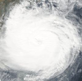
![]() Cyclone Thane is the tenth depression from the north Indian ocean while the fifth depression and the third deep depression from the Bay of Bengal. It is also the second tropical storm from the Bay of Bengal according to the Joint Typhoon Warning Centre (JTWC). It is the second cyclonic storm of the current year in the north Indian ocean according to the Indian Meteorological Department. Storms this year from the Bay of Bengal has been weak as compared to previous year. Thane is a name given by Burma, the word Thane means feudal lord.
Cyclone Thane is the tenth depression from the north Indian ocean while the fifth depression and the third deep depression from the Bay of Bengal. It is also the second tropical storm from the Bay of Bengal according to the Joint Typhoon Warning Centre (JTWC). It is the second cyclonic storm of the current year in the north Indian ocean according to the Indian Meteorological Department. Storms this year from the Bay of Bengal has been weak as compared to previous year. Thane is a name given by Burma, the word Thane means feudal lord.
On December 23, a low pressure formed ESE of Srilanka in the southern Bay of Bengal at 1009 mbar. The next day it intensified into well-marked low pressure as pressure dropped to 1003 mbar though it was expected to move WNW, it remained stationary over the same area due to the approachment of western disturbance 11. On December 25, the severe low pressure started showing spiral bands around it with deepening at the centre and the next morning it was declared a depression BOB 05 at 1000 mbar. On December 26, it intensified into a deep depression at 998 mbar and other day it intensified into a cyclone ‘Thane’ at 994 mbar over the southern Bay of Bengal just 750 km away from Chennai. On December 28, it intensified into a major category-1 hurricane maintained that intensity till the evening of December 29 at pressure 976 mbar with winds reaching 105 mph, the storm also developed a poorly organized eye during the same day. On early December 30, Thane made landfall between Cuddalore and Puducherry as a low end category-1 hurricane with 145 km/h winds lashing Puducherry during the same evening it rapidly weakened into a tropical depression and during the night it rapidly weakened into a low pressure.
December tropical activity in the Bay of Bengal

Since 2005, there had been December storms in the Bay with the exception of 2006 and 2007. Following is the list of those storms;
- In 2011 – Cyclone Thane, as depression formed on December 25 and dissipated on ?
- In 2010 – A depression formed on December 7 and dissipated the next day, it made landfall over Andhra Pradesh.
- In 2009 – Cyclone Ward formed on December 10 and dissipated on December 16, it made landfall over northern Srilanka.
- In 2008 – A deep depression formed on December 4 and dissipated on December 7, it also made landfall over Srilanka, its remnants entered the Arabian sea.
- In 2007 and 2006 (no tropical activity in December)
- In 2005 – Not one but two systems formed in the Bay, a category-1 cyclone Fanoos formed on December 6 till December 10, it made landfall over Srilanka but also caused damage in India’s Tamil Nadu. The second storm, deep depression formed on December 15 and dissipated over the open sea waters of the Bay on December 22.
![]()
![]()
(Updates will be issued at 1:30 pm and 9:30 pm IST)
Overview of very severe cyclonic storm ‘Thane’
Following is the overview of cyclone Thane;
- Formed and dissipated: December 23 – December 30, become a depression on December 25.
- Heaviest rain: 150 mm in Puducherry, Thane had about 500 mm but most of the precipitation fell in the Bay of Bengal before it could make to land.
- Strongest winds: Winds gusted to 145 km/h in Cuddalore and Puducherry. Thane had the highest winds of 140 km/h.
- Lowest pressure: 976 mbar over the Bay of Bengal.
- Fatalities: 30+ in Tamil Nadu coast.
- Twin cyclone of Thane: Cyclone Benidle in the southern hemisphere.
Update issued at 12:00 pm IST on December 30
![]() “Cyclone Thane makes landfall this morning!!”
“Cyclone Thane makes landfall this morning!!”
LAST UPDATE: Cyclone Thane, a category-1 hurricane has made landfall between Cuddalore and Puducherry this morning and due to land interaction it has started weakening rapidly. Strong windstorms lashed southern Indian coast about (140 km/h) winds lashed over Puducherry and Cuddalore with heavy intensity precipitation. So far rain has continued in Chennai with showers continuing since yesterday morning with fast to strong winds (65 km/h), a total of 92 mm rainfall occurred in the city. Following are the main features of the storm as of now;
- Movement: W
- Winds: 70 mph
- Pressure: 983 mbar (rising)
- OVER LAND: Southern India
Thane is now weakening as heat supply as been cut off from the Bay the storm will continue to bring heavy rain as it moves further inward. The remnants of Thane might either start to move into the Arabian sea after December 30 or move towards central India and dissipate there. Thane has now become an unimportant storm as it is now on the route of weakening.
Update issued at 10:30 pm IST on December 29
Cyclone Thane is 160 km ESE of Chennai about 20 mm rainfall with strongest winds of 56 km/h occurred in the city. Its raining in the city with strong winds (50 km/h) as of now. Heavy rainfall along with strong windstorms (100 km/h or greater) could occur in northern Tamil Nadu and adjoining Andhra Pradesh till tomorrow. Following are the main features of the storm as of now;
- Movement: W
- Winds: 85 mph gusting to 105 mph
- Pressure: 976mbar
- UNDER THREAT: Southern India
- LANDFALL HAPPENING: Northern Tamil Nadu
Thane has started weakening due to interaction with rough land surface.
Update issued at 1:30 pm IST on December 29
Tropcial cyclone Thane is 250 km ESE of Chennai, light rainfall that started from yesterday night has continued till now with fast winds (37 km/h), the rain intensity is very likely to gain strength during the evening and winds could reach (50 – 70 km/h). Due to rough land surface, decrease in sea temperatures and increase in vertical wind shear, Thane would weaken from tonight. Following are the main features of the storm as of now;
- Movement: WNW
- Winds: 85 mph gusting to 105 mph
- Pressure: 976 mbar (dropped further)
- UNDER THREAT: southern India
Thane has also formed an unorganized eye in the centre that can be viewed from Infra-red images. Thane is expected to make landfall on December 30.
Update issued at 9:30 pm IST on December 28
Category-1 cyclone Thane has intensified further in the last 6 hours as pressure has dropped to 980 mbar. The sea temperatures are (27°C – 29°C), the cyclone is currently over the area of weak vertical wind shear therefore it might intensify further before weakening. Before landfall Thane would weaken. Following are the main features of the storm as of now;
- Movement: WNW
- Winds: 85 mph gusting to 105 mph
- Pressure: 980 mbar
- UNDER THREAT: southern India
Severe rainfall (above 150 mm) expected with strong windstorms from December 29 with increase in intensity later the day. Thane is 450 km ESE of Chennai, light drizzle occurred today in the city due to the spiral bands of the storm. Landfall is expected on December 30.
Update issued at 2:30 pm IST on December 28
Cyclone Thane has intensified into a category-1 hurricane. Following are the main features of the storm as of now;
- Movement: WNW
- Winds: 75 mph gusting to 90 mph
- Pressure: 987 mbar
- UNDER THREAT: southern India
Forecast remains same, landfall expected on December 30, severe weather expected in northern Tamil Nadu and southern Andhra Pradesh by December 29 mid-day/evening. However Thane would weaken by the city it reaches for landfall due to increase in vertical wind shear and land interaction.
Update issued at 9:30 pm IST on December 27
Cyclone Thane has intensified further as pressure has dropped to 992 mbar, the cyclone is moving extremely slow. The area over which the cyclone is rotating has weak wind shear as well as high temperatures (26°C – 27°C), quite favourable. Thane is expected to intensify into a category-1 hurricane as it aims towards northern Tamil Nadu and adjoining Andhra Pradesh. Due to slow movement, its time of landfall has been delayed however the storm would weaken by the time it reaches the land. The outerbands of the cyclone are touching the southern coast of India while the trough is extending into Burma. Latest images indicates that the around the centre, about 500 mm rainfall is present in the thunderstorms of Thane.
Following are the main features of the storm as of now;
- Movement: WNW
- Winds: 70 mph gusting to 85 mph
- Pressure: 992 mbar
- UNDER THREAT: southern India
Since the cyclone has been almost stationary, severe weather could start in southern India by tomorrow night. The cyclone is now 650 km ESE of Chennai, few low lying clouds are entering the city with little to no breeze at the moment.
Update issued at 1:30 pm IST on December 27
![]() “Cyclone Thane has formed in the Bay of Bengal”
“Cyclone Thane has formed in the Bay of Bengal”
As expected, deep depression BOB 05 has overnight intensified into a cyclone named ‘Thane’, the cyclone may intensify further and could attain a category-1 hurricane status by night/tomorrow as wind shear is likely to become weak and sea temperatures are 26°C – 27°C, quite favourable. Following are the main features of the storm as of now;
- Movement: WNW
- Winds: 50 mph gusting to 60 mph
- Pressure: 994 mbar
- UNDER THREAT: southern India
Thane has obtained a hurricane-like shape with spiral bands extending into southern India an Srilanka, a trough over Burma prevails. Heavy rain showers along with gale winds (50 mph/greater) are expected in northern Tamil Nadu and adjoining area as cyclone moves closer. Thane is 750 km ESE of Chennai.
Update issued at 9:30 pm IST on December 26
Deep depression BOB 05 has been gaining momentum all day long, it is expected to intensify into a cyclone in next 12 to 24 hours. The trough can been seen stretching towards Burma, giving an overcast conditions over the country. The wind shear in the Bay of Bengal is currently moderate (20 knots). The sea temperatures are also favourable for further intensification. Following are the main features of the storm;
- Movement: WNW
- Winds: 35 mph gusting to 40 mph
- Pressure: 998 mbar
- Under threat now: southern India
Heavy rain showers are expected from tomorrow in southern India with strong winds (35 mph),which will gradually increase as the cyclone moves closer. Winds (50 mph or greater) would blow in coming days with chance of severe rainfall. The expected cyclone is expected to make landfall over northern Tamil Nadu on December 28. At the moment, the storm is 800 km ESE of Chennai.
Update issued at 1:30 pm IST on December 26
This morning’s depression has intensified into a deep depression BOB 05 at 998 mbar, it is expected to intensify further into a cyclone. Moisture from BOB 05 has reached Burma while the spiral bands have touched the coast of India as well as Srilanka. Tamil Nadu and adjoining coast of India is under threat from this storm. Following are the main features of this storm as of now;
- Movement: WNW
- Winds: 35 mph
- Pressure: 998 mbar
- Under threat now: southern India
Severe stormy conditions are expected along the coast from December 27 evening. Heavy downpour along with strong winds (50 mph) expected along the southern coast of India.
Tropical poll
Pakistan Weather Portal (PWP) wants to know;
