This article is shared by Farjad Akmal for PWP from Karachi city, Sindh, Pakistan
Large earthquakes along the Makran Subduction Zone (MSZ) have generated destructive tsunamis in the past (Berninghausen, 1966). Although the historic record is incomplete, it is believed that tsunamis from this region had significant impact on several countries bordering the Northern Arabian Sea and the Indian Ocean. The tsunami generated along the MSZ on November 28, 1945 was responsible for great loss of life and destruction along the coasts of Pakistan, Iran, India and Oman (Qureshi, 2006; Pakistan Meteorological Department 2005; Mokhtari and Farahbod, 2005; Pararas-Carayannis, 2006a). The effects of this tsunami on other countries bordering the Indian Ocean have not been adequately documented.
Reports on the potential for tsunami generation along the Makran coast of Pakistan have been cursory. Based on a thorough review of recent geophysical surveys and seismic data, the present study analyzes the potential tsunami generation mechanisms along the MSZ by reviewing subduction processes of the Oman oceanic lithosphere underneath the Iranian microplate and – more specifically – the seismotectonics of the east and west segments, including the section in the Gulf of Oman. Furthermore, the study examines the seismo-dynamics of compressional collision of the India and Eurasia plates along the northwestern boundary of India in the vicinity of the Northern Arabian Sea – as potential sources of future tsunamis and evaluates the tsunami risk from major earthquakes along coastal Karach, the deltaic Indus region and the grabens of Northwestern India. Finally, the study evaluates the possible effects of the extensive sedimentation from major rivers in the region on subduction processes.
THE TSUNAMI OF 28 NOVEMBER 1954 ALONG THE MAKRAN COAST OF PAKISTAN IN THE NORTHERN ARABIAN SEA
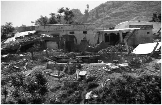
On November 28, 1945, an earthquake, off Pakistan’s Makran Coast (Balochistan) generated a destructive tsunami in the Northern Arabian Sea and the Indian Ocean. More than 4,000 people were killed in Pakistan by both the combined effects of the earthquake and the tsunami. However, the tsunami was responsible for most of the loss of life and the great destruction, which occurred along the coasts of Iran, Oman and northwestern India (Pararas-Carayannis, 2006b).
THE EARTHQUAKE
The great earthquake occurred at 21:56 UTC (03:26 IST), on 28 November 1945). Its epicenter was off the Makran coast at 24.5 N 63.0 E (24.2 N, 62.6 E according to USGS, in the northern Arabian Sea, about 100 km south of Karachi and about 87 kms SSW of Churi (Baluchistan), Pakistan. The quake’s focal depth was 25 kms.
The earthquake’s Richter Magnitude (Ms) was 7.8. The Moment Magnitude (Mw) was later given as 7.9 and reevaluated to be 8.1 (Pacheco and L. Sykes, 1992). The quake was recorded by observatories in New Delhi, Kolkata (Calcutta) and Kodaikanal. Its intensity was high throughout the region. It was strongly felt in Baluchistan and the Las Bela area of Pakistan. It was reported that in the western and southern sections of Karachi the strong surface motions lasted for about 30 seconds. According to eyewitness reports, people were “thrown out of their beds”, doors and windows rattled, and windowpanes broke. The underwater cable link between Karachi and Muscat (Oman) was damaged, disrupting communications. The lighthouse at Cape Moze – 45 miles from Karachi – was also damaged. The earthquake was strongly felt also at Manora, where the lighthouse was damaged. It was moderately felt in Panjgaur and Kanpur.
Other Earthquake Effects
The earthquake is reported to have caused the eruption of a mud volcano a few miles off the Makran Coast of Pakistan (Wadia, 1981). The eruption formed four small islands. A large volume of gas emitted at one of these islands, is reported to have sent flames “hundreds of meters” into the sky (Times of India 1945; Mathur, S.M. “Physical Geology of India). Such mud volcanoes are not uncommon in the Sindh region of the Makran coast. Their presence indicates the existence of high petroleum deposits. They are known to discharge flammable gases such as methane, ethane and traces of other hydrocarbons. The observed flames resulted from emitted natural gas which caught fire after the earthquake.
THE POTENTIAL OF TSUNAMI GENERATION ALONG THE MAKRAN SUBDUCTION ZONE AND THE KUTCH GRABEN IN THE NORTHERN ARABIAN SEA
The active, subduction zone along the Makran coast of Pakistan and Iran has produced many tsunamigenic earthquakes in the Northern Arabian Sea in the past and is a potential source region for future destructive tsunamis. As demonstrated by the 1945 event, the region is capable of generating tsunamigenic earthquakes with moment magnitudes up to Mw 8.1. Also, large earthquakes along the Kutch Graben of India have caused major sea flooding and destruction of coastal areas. Extensive sedimentation by major rivers has created unstable continental slope conditions, so the potential of tsunami generation from such sources cannot be overlooked. Understanding the seismotectonics of the region and the subduction processes along the MSZ in particular, is useful in assessing future large/great earthquakes and tsunami hazards in the Indian Ocean.
“Views expressed on Portal Interactive does not represents the views of PWP”

Send your weather articles, research, ideas, videos or pictures on babar.cyclone@yahoo.com Your article would be published on Pakistan Weather Portal (PWP) with your name and city, without any changes. So you could also be the part of Portal Interactive!