“This is a special tropical coverage that started from October 24 and ended on October 31!”
![]()
 Double tropical activity has been observed in the North Indian Ocean’s Arabian sea and Bay of Bengal. On the average there are four to six tropical storms in this basin but this year there had only been one in the Bay if Bengal in October. Indian Meteorological Department (IMD) is the Regional head responsible for monitoring the cyclones. The tropical activity of 2012 in the north Indian Ocean has been the lowest since many years the season has just started with the formation of cyclone ‘Murjan’ in the Arabian sea on October 24 that was being predicted to form in the Bay of Bengal during last week of October. The Joint Typhoon Warning Centre (JTWC) has also declared ‘Murjan’ as a tropical storm.
Various numerical forecasting models showed that the Bay’s system would be much more stronger than the Arabian sea however the Arabian sea depression has intensified more than expected while models show that Bay’s system would not reach cyclonic storm status as of October 24.
Following are the main cyclone related articles made by Pakistan Weather Portal (PWP) in different months;
- Cyclone VS Karachi Saint
- Cyclone goes gaga over Sindh
-
Detailed history of Cyclones in Pakistan (Updated!)
- Cyclone hits Karachi, India – War with Ghazi deepens!
- History of cyclones in the Arabian sea
- Monsoon 2011 and Cyclones – Sub-continent’s coastal threat?
- Super cyclones – The future of the Arabian sea!!
- Hypercanes – Can they happen?
- The Bhola cyclone – Not so “Bhola” at all!
- Cyclone Yemyin – The untold story!
- Is Arabian sea getting ready to give birth to “Tropical storm 2A”?
- Mysterious cyclone of December 1965: Karachi in the eye of the Storm
- Pollute the Arabian sea for stronger Hurricanes before the Monsoon season!
- Cyclones and sea levels are rising but slow!
- Bay of Bengal warming up for a showdown?
Arabian sea
Meteorological History

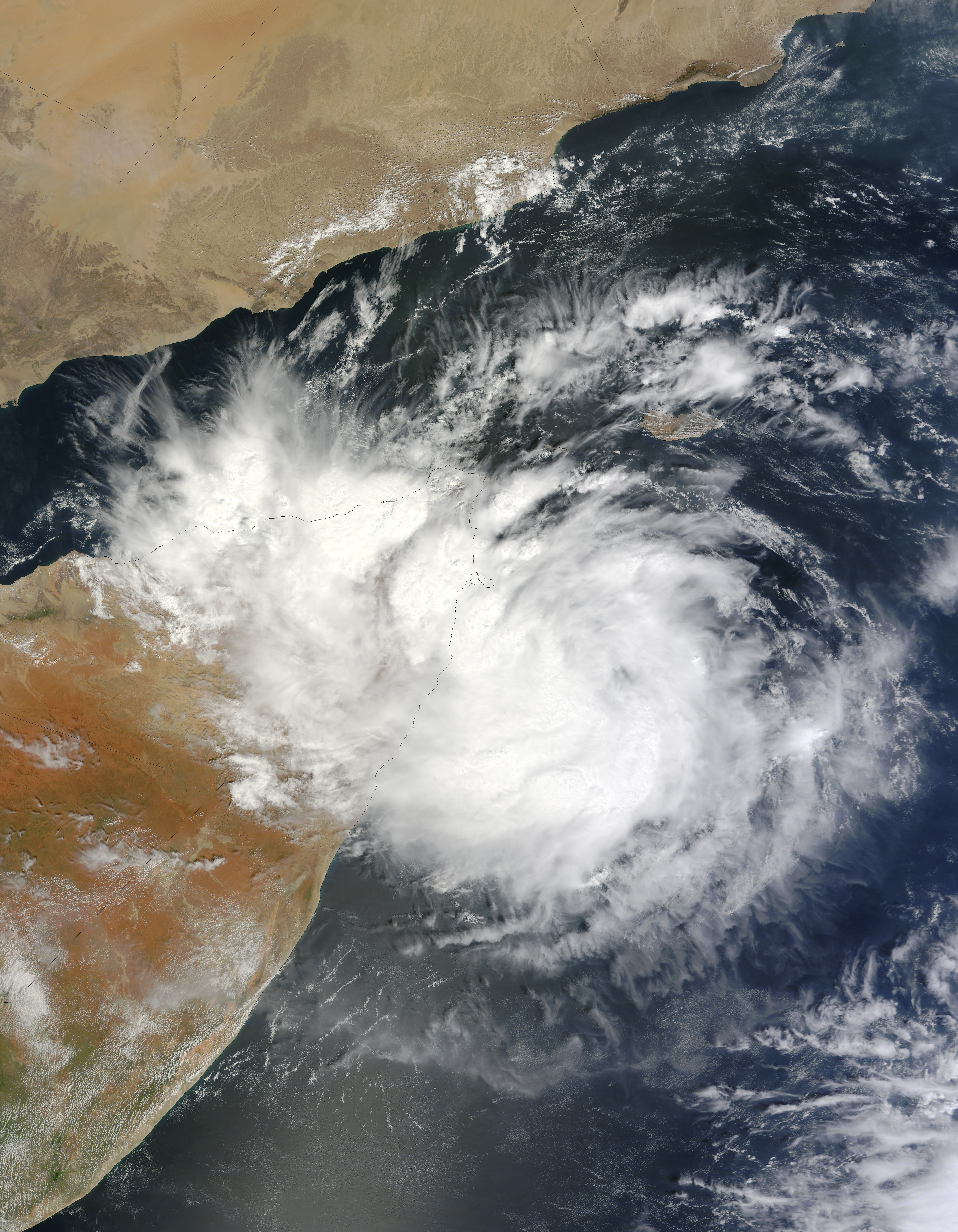
Upper air cyclonic circulation formed over south-east Arabian sea near western coast of India on October 21. As the system moved away from India on October 23, it intensified into a deep depression ARB 01. On October 24, it intensified further at 1000 mbar as the vertical wind shear dropped significantly and became cyclone ‘Murjan’.


Update issued on October 26 at 11:22 am PKT -LAST UPDATE
Cyclone ‘Murjan’ has weakened over land into a depression, and it is likely to move in a WSW direction and dissipate. The rain intensity has decreased while the winds have also dropped. Following are the main features of Murjan at the moment;
- Winds: 56 km/h (reducing)
- Pressure: 1004 mbar
- Movement: WSW
A fresh tropical wave is also forming in the Arabian sea.
![]() Update issued on October 25 at 11:33 pm PKT
Update issued on October 25 at 11:33 pm PKT
“CYCLONE MURJAN MAKES LANDFALL!!”
Cyclone Murjan has made landfall over Somalia as forecasted by PWP, for more details see previous update.
Update issued on October 25 at 10:20 pm PKT
“CYCLONE MURJAN HEADING FOR LANDFALL – SEVERE WEATHER IN SOMALIA NOW!”
Cyclone Murjan is just 160 km east of north-east of Somalia, it is going to make landfall tonight, severe thunderstorms moving into the country. Following are the main features of Murjan at the moment;
- Winds: 65 km/h or greater
- Pressure: 1000 mbar
- Movement: WSW
- UNDER THREAT: Somalia
Heavy downpour (more than 60 mm) along with strong winds (45 km/h gusting to 62 km/h) have already started in north-east cities of Somalia as cyclone is nearing for landfall.
Update issued on October 24 at 10:00 pm PKT
“WARNING FOR SOMALIA!”
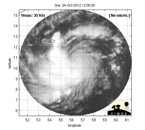
Cyclone Murjan is near north-east of Somalia, it could intensify further during the night of October 24 and would continue to move in a west-south-west direction towards Somalia. It would bring flooding rain with strong winds (75 km/h to 85 km/h) to the north eastern part of the country. Severe thunderstorms are over Socotra Island. Following are the main features of Murjan at the moment;
- Winds: 65 km/h or greater
- Pressure: 1000 mbar
- Movement: WSW
- UNDER THREAT: Somalia
Landfall is expected on October 25 night/October 26 morning, Murjan would weaken before landfall.
Bay of Bengal
Meteorological History
An upper air cyclonic circulation formed over the Andaman sea near Myanmar on October 22. On October 24, it was over the same area with slight intensification.
Update issued on October 31 at 4:00 pm PKT – LAST UPDATE
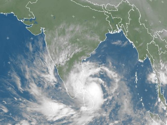
Intensified Cyclone Nilam hitting Tamil Nadu!
Cyclone Nilam is making landfall over Tamil Nadu near Chennai city between Cuddalore and Puducherry coast. Strong winds with periods of heavy rainfall is occurring in the state. Chennai has recorded 74 km/h winds with heavy rainfall of 66 mm till now. The cirrus clouds from Nilam are over central India and eastern Gujarat. Following are the main features of the storm at the moment;
- Winds: 65 mph
- Pressure: 989 mbar,
- Movement: NW
- UNDER THREAT: India (Tamil Nadu and Andhra Pradesh) – LANDFALL HAPPENING NOW
Western disturbance ’04’ lies over northern Afghanistan and it is likely to move into the northern sub-continent thus causing the remnants of Nilam to move in a NNE direction towards north-eastern parts of India.
Update issued on October 30 at 10:30 pm PKT
EAST INDIA BRACING FOR POWERFUL CYCLONE NILAM!

Cyclone ‘Nilam’ continues to intensify as pressure is dropping while the winds are increasing. The storm would create havoc in Tamil Nadu and adjoining areas. Following are the main features of the storm at the moment;
- Winds: 50 mph
- Pressure: 993 mbar.
- Movement: NW/W
- UNDER THREAT: India (Tamil Nadu and Andhra Pradesh) and Sri Lanka
Cyclone Nilam is the strongest cyclone of the current 2012 North Indian ocean cyclone season. Landfall is expected on October 31 with severe weather conditions likely.
Update issued on October 30 at 10:00 am PKT
Deep depression in the Bay of Bengal has further intensified into a cyclonic storm at the pressure of 1000 mbar, it would be given a name “Nilam” soon. Following are the main features of the storm at the moment;
- Winds: 45 mph
- Pressure: 1000 mbar, dropping
- Movement: West/WSW
- UNDER THREAT: India (Tamil Nadu and Andhra Pradesh) and Sri Lanka
This weather system has the potential to bring scattered destruction to the eastern coast of India.
Update issued on October 29 at 12:00 pm PKT
Cyclone Nilam forming in 24 hours!
As forecasted by PWP since October 22, Bay of Bengal’s well-marked low pressure had intensified into a depression on October 28 and today it has further intensified into a deep depression at the pressure of 1002 mbar. It is few spins few from being declared a cyclonic storm ‘Nilam’. Following are the main features of the storm at the moment;
- Winds: 35 mph (56 km/h), increasing
- Pressure: 1000 mbar, dropping
- UNDER THREAT: India (Tamil Nadu and Andhra Pradesh) and Sri Lanka
This weather system has the potential to bring scattered destruction to the eastern coast of India.
Update issued on October 28 at 12:00 pm PKT
Yesterday’s low pressure has intensified into a well-marked low pressure and it is expected to transform into a depression BOB 02 and move in a WSW direction, it could intensify further today. BOB 02 is absorbing all the moisture from Arabian sea system.
Update issued on October 27 at 5:00 pm PKT
Low pressure over south-east has intensified slightly as pressure dropped at 1007 mbar. The JTWC (Joint Typhoon Warning Center) has upgraded the chance of it becoming a tropical storm at medium. This weather system would intensify into a well-marked low pressure on October 28 and move in a WSW direction.
Update issued on October 26 at 11:22 am PKT
Upper air cyclonic circulation over Andaman sea has intensified into a low pressure area at 1008 mbar, it could intensify further and move in a SW direction, fresh tropical wave in the Arabian sea may drag it in a SW direction.
Update issued on October 25 at 10:20 pm PKT
Upper air cyclonic circulation still mostly remains disorganized, it is present in Andaman sea, south-west of Bangkok. It could intensify into a low pressure area on October 26 morning and could intensify further with lowest pressure shown by chart at 1002 mbar/1000 mbar during the last week of October, there are still 100% chance of formation of a depression in the Bay of Bengal.
Update issued on October 24 at 10:00 pm PKT
It could intensify into a low pressure area on October 24 or October 25 and could intensify further with lowest pressure shown by chart at 1002 mbar/1000 mbar during the last week of October, there are still 100% chance of formation of a depression in the Bay of Bengal.
Fight over a name ends!
The Arabian sea’s weather system was not forecasted to intensify beyond depression status and Bay’s system was being predicted to reach a cyclonic storm status during last days of October however a cyclone formed in the Arabian sea therefore it was given a name ‘Murjan’, it is an Arabic word given by Oman which means Corel. The next name on the list is given below;
- Nilam – It is an Arabic word used in Urdu, name given by Pakistan.
Double activity in the past?
It is not the first time that weather systems in Arabian sea and Bay of Bengal were seen moving together. In May 2010, Cyclone ‘Laila’ in the Bay of Bengal while Cyclone ‘Bandu’ in the Arabian sea were seen whirling in their respective waters almost at the same time that is from May 17 till May 21 both the storms took a similar path as these storms are being predicted in 2012.