
-
Westerlies are coming back!
-
Heat wave coming!
-
Karachi to remain calm!

It was feared that due to frequent invasion of westerlies, Pakistan may be abandoned of the important heating trend but we saw that as soon as May started temperature started to rise. It is worth-mentioning the ‘true’ heat waves of summer are missing at the moment. High temperatures have been witnessed only in Sindh and Balochistan while Punjab is missing the heat waves due to flow of westerlies. The second heat wave (stronger than the first) is expected in the coming week in Sindh.
Factors – Outlook
*A weak Western trough ’05’ is over extreme north-eastern areas of Pakistan, it has broke the trend of high temperatures. Another Western trough ’06’ would come on May 9 night, it would follow the same path.
North Remembers – Dusty Shower possible
‘Dust storm can occur in Northern areas!’

Since the coming WD ’06’ would be far away from the major cities of the northern areas of the country therefore most activity can take place in the Gilgit-Balistan province however dusty winds can occur on May 10 till May 12 in the extreme and adjoining northern areas including Peshawar and Islamabad with cloudy intervals. Temperatures can drop by 2°C to 3°C in Islamabad, Lahore, Peshawar, Multan, Bahawalpur, Faisalabad, Gujranwala and adjoining cities due to the presence of western winds from May 10 till May 12 after that temperature would again rise. During this period dust storm with drizzle/isolated shower can occur in the mentioned and their adjoining areas while moderate rain with strong dust storm can occur in Azad Kashmir and adjoining Khyber Pakhtunkhwa.
South runs dry!
The Sindh province’s upper cities like Sukkur can experience dusty winds on May 10/May 11 while the temperatures would remain around 40°C till 42°C. A heat wave is expected in Sindh starting from May 12 excluding coastal areas, temperatures in upper cities can reach 45°C/47°C during that heat wave.
Karachi’s temperature could remain 34°C/36°C during the next coming days with fast winds, partly cloudy weather can also occur.
2013 Monsoon News
![]()
-
Pre-monsoon brings flood to India and Bangladesh
-
Bay of Bengal’s show a flop?
-
Arabian sea to have it’s own show!
Factors – Outlook
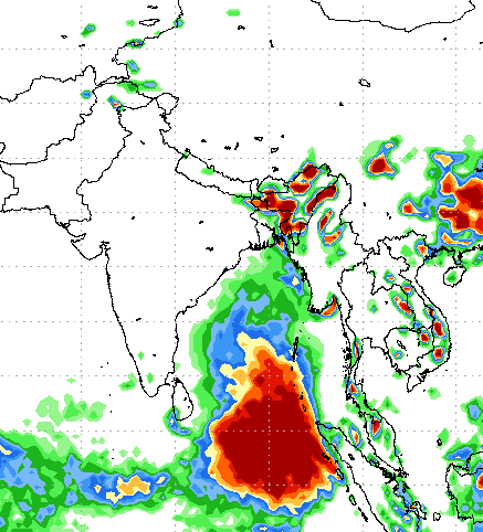
*Low pressure is over southern Bay of Bengal, it could intensify into a cyclonic storm ‘Mahasen’ during the coming, a delay in its formation has occurred. No affect on Pakistan.
Pakistan Weather Portal (PWP) has mentioned the things expected in the rain season in its Monsoon Article – Part II.
Depression BOB 01 – Bay fails to throw a big show !?!

Till the end of this week there would be a depression/deep depression in the southern Bay of Bengal that could affect the eastern coast of India though earlier it was expected to become a strong cyclone and create havoc in the eastern coast but now it can develop into a weak cyclonic storm with pressure of 996/994 mbar.
The system could bring widespread heavy downpour to north-eastern India, Bangladesh and adjoining Burma. During this week, the low pressure/depression can drop around 400 mm rain in the Bay of Bengal!
India and Myanmar
Even before this low pressure, widespread Pre-monsoon downpour has hit North-eastern India, Bangladesh and Burma. Due to intense heating over central India, the onset of monsoon is expected early in India. 90 mm precipitation has occurred in the cities of Bangladesh that has flooded towns.
Arabian sea warming up for something?
During late May, there is a slight possibility for the formation of a depression that it likely to travel till central Arabian sea after that its future is disputed.
Poll of the Week
Pakistan Weather Portal (PWP) wants to know;
