
“This is a special tropical coverage that started from May 13 and will end on May 16”
![]()
![]()

The 2013 North Indian ocean cyclone season started off with the formation of a depression BOB 01 in the Bay of Bengal on May 10 that later intensified into the season’s first full blown cyclone. On average 4 to 6 tropical depressions form in the North Indian ocean, more in the Bay of Bengal than the Arabian sea.
King ‘Mahasen’ cyclone!
Cyclone ‘Mahasen’ formed on May 11 in the southern Bay of Bengal, the word ‘Mahasen’ has been contributed by Sri Lanka. Mahasen was a king of Sri Lanka who ruled the country from 275 to 301 AD.
Rare: Connection of South and North Indian Ocean
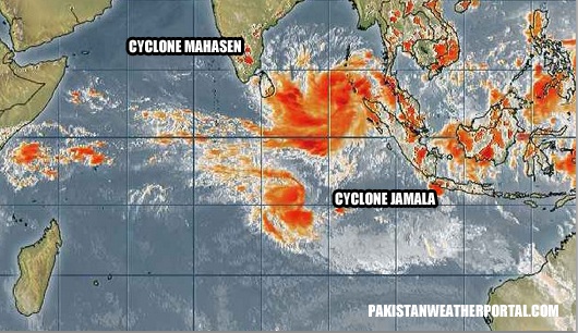
A very rare phenomenon occurred both in the south-west and north Indian ocean. On May 11, cyclone ‘Jamala’ in the south-west Indian ocean was just south of cyclone ‘Mahasen’. Jamala was moving in a clockwise-direction while Mahasen was moving in a counter-clockwise direction however later in the day Mahasen absorbed the moisture from Jamala as it was the larger storm thus leading a end of Jamala.

In May 2002, this phenomenon took place when a cyclone formed in North Indian ocean’s Arabian sea while another cyclone in south-west Indian ocean was near Madagascar. The two storm erupted from the same large area of disturbance.


![]()
Timing of updates – 3:00 pm PKT (mid-day), 6:30 pm PKT (evening) and 9:00 pm PKT (night)
") Update issued on May 16 at 11:00 pm PKT – LAST UPDATE
Update issued on May 16 at 11:00 pm PKT – LAST UPDATE
Tropical cyclone ‘Mahasen’ continues to lose intensity as it moves in a NE direction, it is not significant now. Cyclone ‘Mahasen’ brought rain to Indonesia, Thailand, Myanmar, Bangladesh, Sri Lanka and India. Following is the death toll from Mahasen;
- Indonesia – None
- Thailand – 1 person
- Mynamar – 8 people drowned on May 14
- Bangladesh – 14 people
- Sri Lanka – 7 people
- India – 9 people
In Sri Lanka, agencies urged the International and the local media to refrain from using ‘Mahasen’ as the name of a destructive storm, as Mahasen was a King of Sri Lanka who brought prosperity to the country. It is worth-mentioning that the Sri Lanka Meteorological Office suggested this name.
Update issued on May 16 at 5:44 pm PKT
![]() 12 die in Bangladesh due to torrential rains and strong winds of 60 mph. There are some unconfirmed reports that say that Burma has escaped the burnt of the storm while 50 injured.
12 die in Bangladesh due to torrential rains and strong winds of 60 mph. There are some unconfirmed reports that say that Burma has escaped the burnt of the storm while 50 injured.
Update issued on May 16 at 2:00 pm PKT
‘Mahasen makes landfall as a significant tropical storm!’
Tropical cyclone ‘Mahasen’ has made landfall as a moderate strength tropical storm, widespread severe heavy downpour with strong gusty winds (56 km/h – 90 km/h) might have occurred in the coast of Bangladesh and adjoining Indian and Burma coast including the Indian city of Kolkata. The storm has weakened now though there are more chances of scattered heavy downpour with strong gusty winds till 6 hours after that significant decrease in rain coverage. Following are the main features of the storm as of now;
- Movement: NE
- Winds: 50 mph (85 km/h)
- Pressure: 990 mbar
- Landfall: Crosses Bangladesh coast
- UNDER THREAT NOW: Bangladesh-Burma and Indian state of Assam
‘Mahasen’ made landfall on May 16 morning as forecasted by PWP since May 13 (May 15 night/May 16 morning) though other websites and few models did say that Mahasen would make landfall on May 16 night, some even went far by saying that Mahasen would make landfall on May 17 morning however in the end the landfall happened as per the forecast of PWP.
Update issued on May 15 at 9:00 pm PKT
‘Mahasen approaching for landfall – Bangladesh awaits Severe heavy rainfall’
Tropical cyclone ‘Mahasen’ is quickly moving towards Bangladesh-Burma coast, it will start to weaken by May 15 night due to once again increase in vertical wind shear as it makes landfall over Bangladesh-Burma coast. Following are the main features of the storm as of now;
- Movement: NE
- Winds: 50 mph (85 km/h)
- Pressure: 990 mbar
- Landfall: Bangladesh-Burma coast (Tonight/May 16 morning)
- UNDER THREAT NOW: Bangladesh-Burma and Indian state of Assam
Showers with gusty winds expected in Orissa and West Bengal coast till one hour. After one hour widespread severe heavy downpour likely in Bangladesh, Indian state of Assam and adjoining coast of Burma with strong gusty winds (56 km/h till 85 km/h).
Update issued on May 15 at 3:00 pm PKT (Also for 6:00 pm)
Tropical cyclone ‘Mahasen’ intensified slightly as it is moving towards its final destination that is Burma-Bangladesh coast. Mahasen would start to weaken rapidly on May 15 mid-day/evening due to once again increase in vertical wind shear as it makes landfall over Bangladesh-Burma coast. Following are the main features of the storm as of now;
- Movement: NE
- Winds: 50 mph (80 km/h)
- Pressure: 990 mbar (dropped)
- Landfall: Bangladesh-Burma coast (May 15 night/May 16 morning)
- UNDER THREAT NOW: North-Eastern coast of India and Bangladesh
Heavy downpour with strong gusty winds (above 56 km/h) expected especially in north-eastern coast of Andhra Pradesh and coast of Orissa during the next six hours after that stormy conditions expected in West Bengal and Bangladesh. The storm is 700 km south-west of Chittagong, Bangladesh.
Update issued on May 14 at 9:00 pm PKT
Tropical cyclone ‘Mahasen’ has re-curved and it is quickly moving towards Bangladesh-Burma coast. In a NE direction it may intensify into a category-1 hurricane or even a low end category-2 hurricane as the sea temperatures are high while the wind shear is slightly low in that area. Mahasen would start to weaken rapidly on May 15 mid-day/evening due to once again increase in vertical wind shear as it makes landfall over Bangladesh-Burma coast. Following are the main features of the storm as of now;
- Movement: NE
- Winds: 50 mph (80 km/h)
- Pressure: 996 mbar
- Landfall: Bangladesh-Burma coast (May 15 night/May 16 morning)
- UNDER THREAT NOW: Eastern coast of India
Severe heavy downpour likely on Wednesday in Bangladesh and Burma with gale force winds. The storm has killed seven people in Sri Lanka.
Update issued on May 14 at 3:00 pm PKT (also for 6:00 PKT)
Tropical cyclone ‘Mahasen’ is just 400 km south-east of Indian city of Vishakhapatnam while 1140 km south-west of Chittagong. The system is under a area of moderate vertical wind shear as it is moving in northwards therefore Mahasen has weakened, it will move in this direction briefly before taking a sharp re-curve in a NE track. Once it moves in a NE direction it may intensify into a category-1 hurricane or even a low end category-2 hurricane as the sea temperatures are high while the wind shear is slightly low in that area. Mahasen would start to weaken rapidly on May 15 mid-day/evening due to once again increase in vertical wind shear as it makes landfall over Bangladesh-Burma coast. Following are the main features of the storm as of now;
- Movement: N
- Winds: 50 mph (80 km/h)
- Pressure: 996 mbar
- Landfall: Bangladesh-Burma coast (May 15 night/May 16 morning)
- UNDER THREAT NOW: Eastern coast of India
Indian states of Orissa, coastal Andhra Pradesh and Tamil Nadi can get showers at time moderate with windy conditions (46 km/h to 56 km/h).
Update issued on May 13 at 6:00 pm PKT (also for 9:00 pm)
Tropical cyclone ‘Mahasen’ is just 700 km south-east of Indian city of Chennai while 1300 km south-south-west of Bangladeshi city of Chittagong during last few days it has moved in a WNW direction and due to the incoming westerlies, Mahasen is likely to curve in a Northwards direction briefly before taking a sharp re-curve in a NE track, at the moment the system is slowly moving in a NW direction almost stationary. Mahasen may intensify further into a category-1 hurricane or even a low end category-2 hurricane but the storm would accelerate after taking the NE track therefore the chances of intensification are low. Mahasen would start to weaken rapidly on May 15 mid-day/evening due to increase in vertical wind shear as it makes landfall over Bangladesh-Burma coast. Following are the main features of the storm as of now;
- Movement: NW
- Winds: 55 mph (88 km/h)
- Pressure: 996 mbar
- Landfall: Bangladesh-Burma coast (May 15 night/May 16 morning)
- UNDER THREAT NOW: Eastern coast of India
As of today, Showers have occurred in Chennai. Indian states of Orissa, coastal Andhra Pradesh and Tamil Nadi can get showers at time moderate with windy conditions (46 km/h to 56 km/h). Sri Lanka can experience frequent moderate rain with isolated heavy falls and strong winds (above 56 km/h) as the outer bands have gripped Sri Lanka.

after mahasen chances will tropical activities in Arabian sea?
I have mentioned in the last article that there is a possibility of a tropical activity in arabian sea.
Qavi
Yes we will have possibility of depression or Cyclone formation in Arabian sea in coming Sun/Mon.
Get ready in a week or less–of the remains of the moisture from the cyclone could start moving west to Arabia, crossing Arabia and head straight for Pakistan?
There are chances of Tropical activity in Arabian sea during late May.
the “cyclone after 2 years” myth won’t disappoint us this year I hope =D
PWP once again says that cyclone can come after two years!!!!!! This year it can come!! :)
‘The cyclone legend in Arabian Sea is passed down through ages.. and it seems that a lot of people believed in it. It was the legend of cyclone occurring in the Arabian sea after two years. One of the main resource was found in a settlement at Arabian Sea. One work was found in English which is now translated into Hikamu Language was the work of “Baabar’s Meteo”. This book was kept alive in history due to his extensive research of weather. The book seems to be published back in 20th century, when people had gone crazy over oil.
Written by Someone in January 18, 3015… :P
WOW splendid work !! You brought the news from the future ;)
AFTER “MAHASEN” Arabian Sea Cyclone “PHAILIN” To HIT OMAN ..or gujrat this may..
and pak coast ?
There are chances of a tropical activity in ARB, to early to give a final verdict on its track
nice
:)
Friday, May 17, 2013Circulation over S,S-E Arabian sea and Rain for Kerala
South West Monsoon is likely to advance over Kerala on June 3: IMD >
The cross equatorial winds are expected to become strong along S,S-E Arabian sea in next 2 days …
The present weak circulation over S,S-E Arabian sea is expected become marked in next 2 days .
On Tuesday evening, the S-E Arabian sea circulation is expected to intensify and move N-W …
AN UAC is likely to form off the Kerala coast on Sunday, 19th. Could be located to the SW off the coast of Kerala.
Would sink to a sea level low (1006mb) on Monday.
51C in Larkana ? OMG!!!
Yes !! Its burning!
ARABIAN SEA MAY 2013: SITUATION FLUID: A LOW PRESSURE AREA HAS FORMED
A great mass of dense clouds hover over southern Arabian Sea. This mass has a great potential of throwing out many possibilities. A low pressure area? A cyclone? A super cyclone? Where? Gujarat? Oman? Pakistan?
Conditions are very fluid and model forecasts are a little bewildered too. Hence different predictions with each forecast. One thing is certain. A low pressure area has formed in the southern Arabian Sea.
For those interested, latest forecasts say the low pressure area will potter around for a couple of days (May 20) and then head towards the coast of south Oman and hit it on May 22. 2013 near Sharbatal, Sawqirah and Marmul. These areas will receive heavy rains.
But as we said conditions are very unstable and so we shall have to wait and see what happens next.
Source ?
Can you confirm PWP ? Is there a low pressure in the ARB ?
PWP did say in its article on May 8 that a depression might form in Arabian sea and move towards central Arabian sea.