Torrential rain brings Karachi to standstill !

‘Almost every year Monsoon brings Karachi to standstill’

During Storm and After Storm - Courtesy Twitter
During Storm and After Storm – Courtesy Twitter

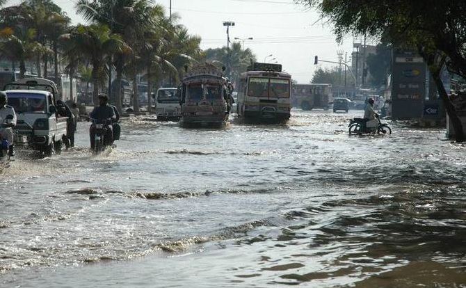
People who say that it doesnt rain much in Karachi should change their view because when it rains it pours as if there is no tomorrow though the number of days of rain is indeed less in the metropolis. Karachi lie in the monsoon season so its not surprising to see torrential rains here or streets getting flooded during the summer season which is quite common in the Indian sub-continent.  The mega city Karachi was once again brought to it’s knee when typical monsoon rain started in the city on August 3  morning and continued till evening in some parts.

What caused the rain?

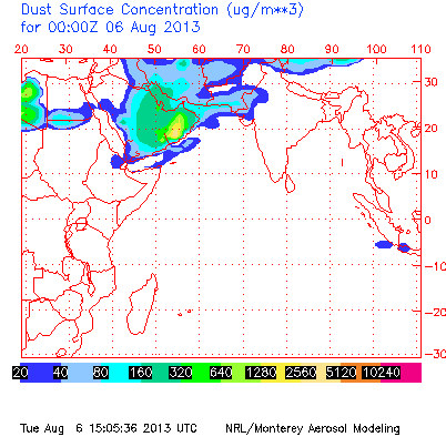
Karachi experienced it’s first monsoon deluge of the year due to the remnants of a tropical depression BOB 03 that formed in the Bay of Bengal on July 30 and traveled all the way from eastern India to central India and then to southern Pakistan.

On August 3, remnants lied over eastern Sindh and adjoining states of India as an upper air cyclonic circulation (weaker than a low pressure – extremely weak than a depression). Despite being an UAC it brought above 50 mm rain to many cities of Sindh. On August 4, the UAC further weakened and moved into Balochistan.

Main features of the August 3’s weather

Following are the main features of the August 3’s weather;

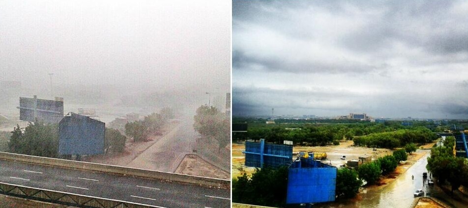
  • Winds: Highest winds were 40 km/h though they can be much higher in North parts of Karachi.
  • Winds direction: During the whole day, wind direction kept changing direction – WSW, NE, ESE, SE, NW.
  • Rain Quantity: 136 mm (5.3 inches) in North Karachi, 74 mm (2.9 inches) in DHA (south) Karachi.
  • Duration of rain: The rain started from 10:00 am PKT and lasted till 10:30 pm PKT.
  • Humidity: The highest humidity was 94%.

Storm leaves death and destruction

According to government sources, 8 people have been reported dead due to the rain-related incidents while major roads of the city have witnessed heavy flooding. TV Footage shows cars overturned in some areas of the city due to the power of floodwater.

Flash flooding has left 38 people dead in Pakistan province of Khyber Pakhtunkhwa and Balochistan. Every year more than 100 people die due to the monsoon season in the Indian sub-continent.

More rain coming?

On August 4, parts of Karachi again experienced moderate to isolated heavy rain during the early hours of the day but the good news is that the current spell is over and there are no chances of moderate to heavy rain till few days. The authorities should immediately clean the flood water as new rains can come to Karachi in few days, fresh weather system is forming in the Bay of Bengal. More rains can occur in the metropolis during the coming week that is August 8/August 9, update will be given if necessary. Will Karachi survive the next rain?

62 replies to “Torrential rain brings Karachi to standstill !

  1. Dear Babar: The southen strip of Tharparkar has recieved very light rainfall while Mithi has recieved 12.5 mm rainfall on 3rd August and 12.mm on 2nd August 2013. Any update for the next spell in Umerkot and Tharparkar.

    1. Eastern Sindh got less rain than southern and northern parts of Sindh. Around there can be another rain spell near Sindh, update about them will be given when necessary.

  2. After these rains now the statement of “No heavy downpour till 1st week of september in sindh” has been changed or still there will be no proper monsoon in SIndh?

    1. Long range model continues to show no rain however short range model do show rain August, short range are not fruitful about September.

  3. The DUST CLOUD has moved away from Pakistan according to the NAAPS images today, and there are two huge blocks of moisture that may come in the next week or so–the first is east of India and the second is currently east of China. These two batches of moisture when the pass over Pakistan, may be a good test of the interaction of the Dust Cloud on the monsoon.

  4. Babar, if rain in KHI and Sindh because of remnants of a depression tou what would be the height of miseries for KHI if a derpression or well marked low manage to enetered in sindh or KHI considering the current position of infrastructure and Gov preparation……..my God that will be horrendous to see… 😦

    1. You remember what happened in Sindh in 2011 ?

      Well-marked lows wreaked havok in SE Sindh. 1300+ mm rainfall was recorded in Mithi.

    2. During this rain the most destruction was due to the ill preparedness of the local government. Storm drainage systems were not cleaned on time.

    1. It didn’t affected my area. Areas close to Safurah were submerged in water. People were helping themselves, no authorities were present there at the time of flood. The situation is getting better now.

  5. Tarim / Babar, just saw a discussion on Geo program ‘Capital Talk’ where chairman NDMA(National Disaster Management) has warned that there would be even more torrential rains in September in central , Southern and Balochistan and authorities should prepare themselfs on war footing basis.

    1. Yeah I saw it too. We knew it long ago when PMD launched there long range monsoon forecast in June. The NDMA chairman was talking about the same forecast.

  6. Pakistan today, according to the NAAPS images, the DUST CLOUD is still absent except in the Arabian Sea offshore, and there are four batches of intense moisture heading toward the county, three are in central India and the fourth is hitting the coast of China right now.

    If the Dust Cloud moves further west towards Arabia, then the moisture can move past Pakistan and rain without much flooding. However, if a pocket in the Cloud forms, then the monsoon is trapped over the country and it can stall and cause floods again.

    1. Aoa babar bhai. In Sixth spell Risalpur received little rain only for one day. the other days were dry. Is there chances of Rain in Risalpur In the seventh spell.? When you issue your monsoon update daily you not mention district nowshera in your daily monsoon update.

      1. Walikum Assalam Imtiaz.
        I mostly mention those areas that have high probability rain chance. Passing clouds with chances of rain/showers in Risalpur till tomorrow morning/mid-day.

  7. GFS showing the current low pressure dissipating over central India. It also shows another strong low pressure bringing moving towards central India from 12 august.

  8. PMD said in their forecast that rainfall would mainly concentrate over central and Southern areas of Pakistan from August till September.

  9. Today the Dust Cloud is forming a pocket over northern Pakistan, that you can see at http://www.ecoseeds.com/dust-pocket.png, which mean that if monsoon moisture moves into the pocket, it can get trapped and stall, and potentially cause floods.

    I am curious about two things: 1.) When the Dust Cloud went away, how clear were the skies, how far could you see, compared to when the Dust Cloud is present?
    2.) Shouldn’t the Pakistan Meteorological Department be giving out daily Dust Cloud-monsoon reports, that could be posted here?

  10. Babar / Tarim, what exactly has been happening in IRAN and AFghanistan? i mean wahan par bhi achi khacsi barshen ho rahi hen. I had neven seen in the past that moonsoon clouds has ever crossed Balochistan even Balochistan me bhi moonsoon itna actively aggression show nahi karta tha but nowadays things have completely changed now.

  11. Thanks to Mr.Craig for updating us on regular basis.
    Babar bhai,please post the link of an image from which I may get the current pressure situation of our region.

  12. Today, five interesting monsoon storms, two parallel with the coast in Iran, one in central India, and two huge ones in SE Asia, in coastal China and the Thailand-Vietnam area. Each of these five storms are probably causing flooding wherever they are currently located. The Dust Cloud pocket is still in northern Pakistan. Maybe the Pakistan Dust Cloud should get a name in one of the languages of Pakistan? Any suggestions?

  13. Dear Craig Dremann,
    “Aber-e-khak” can be a suitable name for Dust Cloud. Post the link of an image from which I may see the current synoptic situation of our region on daily basis.

  14. From the satellite data right now, the pocket is in the Dust Cloud in northern Pakistan, and a storm is breaking off from the cluster that has been over India for a few days and is moving towards the pocket right now.

    1. I dont think that ‘flooding’ rains can come, average rain for Karachi in September is 22 mm, even little rain in September exceeds the average. Old runs by model showed improvement in rain activity in south Pak though northern areas of Pak were since day one expected to get good rains which they are getting. Latest runs by few Models show weakening activity of monsoon in September.

Leave a Reply

Fill in your details below or click an icon to log in:

WordPress.com Logo

You are commenting using your WordPress.com account. Log Out /  Change )

Facebook photo

You are commenting using your Facebook account. Log Out /  Change )

Connecting to %s

%d bloggers like this:
close-alt close collapse comment ellipsis expand gallery heart lock menu next pinned previous reply search share star