
Cyclones that made landfall in Pakistan since 1999
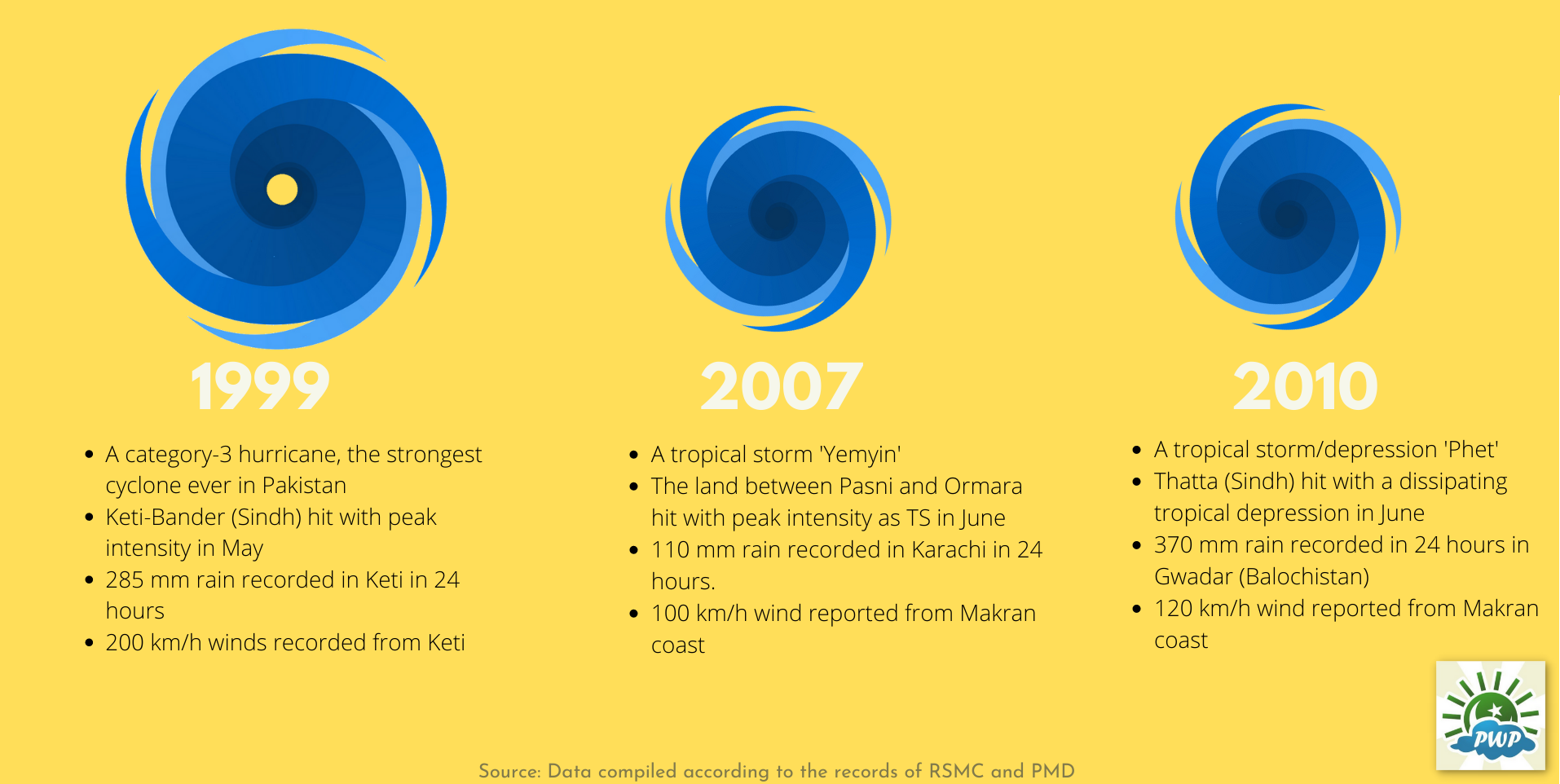
Rain stats of some cyclones in Pakistan;
- 1999 #CycloneKeti 285mm rain in #KetiBandar
- 2004, #CycloneOnil 145mm rain in #Thatta
- 2007, #CycloneYemyin 110mm rain in #Karachi
- 2010, #CyclonePhet 370mm rain in #Gwadar
- 2021, #CycloneShaheen 39mm in #Karachi
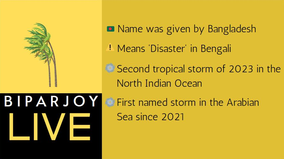
What do We know so far?
17th June – 6:30 PM PKT – LAST UPDATE
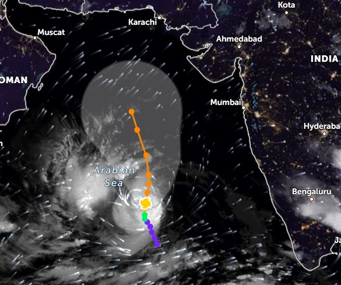
12 days on #CycloneBiparjoy is still ACTIVE! Likely to weaken into a Low in 24 hours and transition into a semi-westerly system.
Breaks the record of Super Cyclone ‘Kyar’ to become the longest-lasting storm in the Arabian Sea
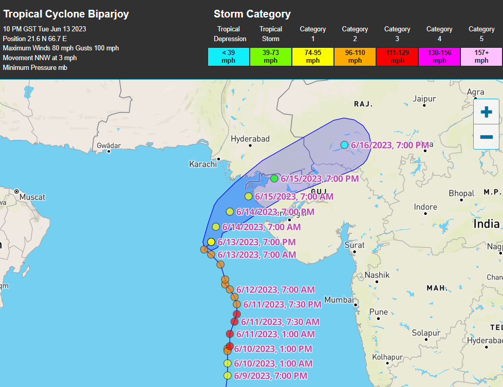
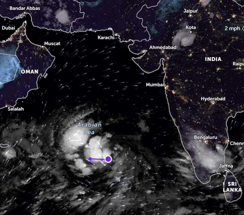
Yesterday’s Cyclone Biparjoy entered Pakistan’s southeastern Sindh province from Gujarat while maintaining a ‘tropical storm’ status on the SSHWS scale. This is a highly unusual event as it remained cyclonic status for about 12 hours over land. Commonly, tropical storms do lose such strength as interacting with land cuts moisture supply while the environment in this part of the world is already hostile to such storms given the abundance of wind shear, and dry and desert regions nearby.

(Cyclone Biparjoy entering SE Sindh)
Given that it entered Pakistan with a tropical storm status, I see no reason why it should not join the ranks of Cyclone Keti (1999), Cyclone Yemyin (2007) and Cyclone Phet (2010) in the list of cyclones that hit Pakistan. Though the usage of ‘landfall’ cannot be used as it came from land-to-land rather than sea-to-land.
The storm led to record-breaking pre-monsoon tropical downpours (24 hours) in SE Sindh;
-269 mm of rain in Nagarparker
-196 mm of rain in Mithi
-175 mm of rain in Diplo
-143 mm of rain in Islamkot
Cyclone Biparjoy has since then weakened into a tropical depression, it is still a powerful storm that will remain a cause of concern for north-western and central India. It has transitioned into a semi-westerly system as well. Normal conditions persist in Sindh including Karachi now.
A monsoon low pressure can form in the Bay of Bengal later this month, which will be worth tracking for monsoon onset.
15th June – 11:59 PM PKT
Cyclone Biparjoy made landfall as a high-end tropical storm over Indian Gujarat, about 210 KM ESE of Karachi, likely to weaken into a tropical depression. Showers continued in Karachi at intervals along with gusty winds. Similar forecast for tomorrow as well.
Chances of tropical heavy downpours accompanied by stormy winds in Keti Bandar, Shah Bandar, Badin, Mithi, and adjoining areas till July 16/July 17 persist though windspeed will reduce to 40 to 60 mph now as the storm is weakening. The strongest part of the storm which is in the South and East sector of the eye is yet to move into the land.
SW wind will restore in Karachi by Friday evening/night as Sea conditions are likely to return to normal as well.
14th June – 11:59 PM PKT
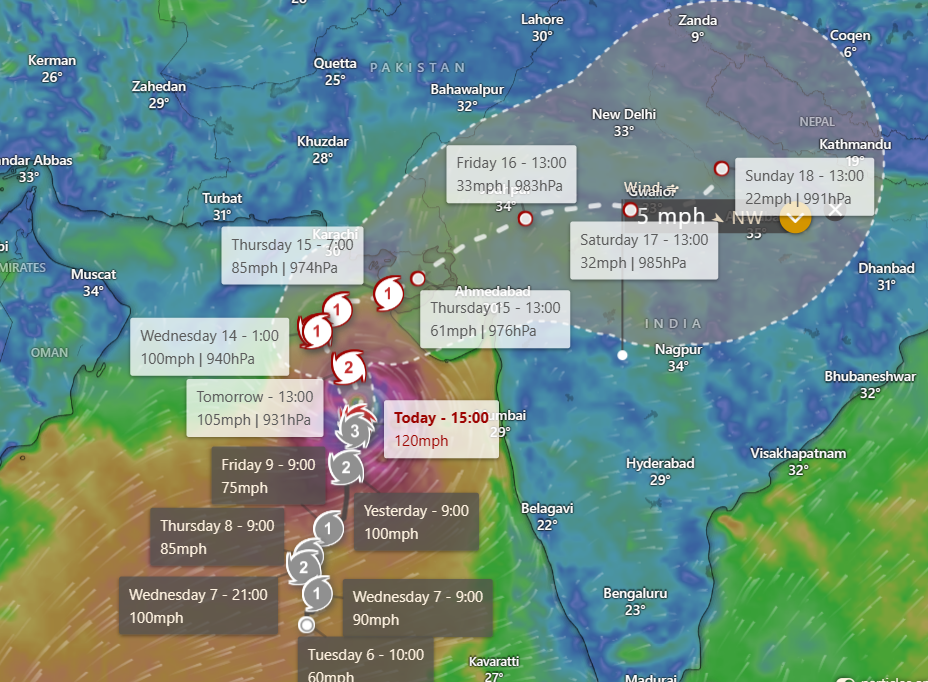
9th strongest hurricane in the Arabian Sea in terms of windspeed (120 mph) joining the ranks of the 1998 Gujarat and 1999 Pakistan cyclones
Cyclone Biparjoy is now 260.71 KM South of Karachi. Eventually, it did recurve in the day. But made an unpredicted loop (NW to WNW to S) before recurving in a NE direction. However, as of writing this, it’s again moving in an N direction. But, there appears less confidence that the track will change now. On Thursday/Friday morning, it is likely to make landfall somewhere between Keti Bandar (Pakistan’s Sindh) to Porbandar (India’s Gujarat) as a high-end tropical storm or a category-1 hurricane.

One of the long-lasting hurricanes in the Arabian Sea
Chances of showers (at times heavy) with gusty winds (45 to 60 mph) on June 14/June 15 (+1 day error) in Karachi. Whereas, chances of tropical heavy downpours accompanied by stormy winds (60 to 90 mph) in Keti Bandar, Shah Bandar, Badin, Mithi and adjoining areas on June 14 to June 16.
Once inland, it will rapidly weaken but it is not the end of Biparjoy as its remnants will travel to north-western India with chances of moving as far as central India, bringing localized downpours.
13th June – 11:59 PM PKT
Due to dry air and wind shear, cyclone Biparjoy has started weakening which is allowing thunderstorms to drift away from the center, giving it a large appearance. The storm is now 363.7 KM South of Karachi.
It is nearly at Pakistan’s coastal border as it continues to move in an NW direction. It still hasn’t made the turn toward the North in order to curve in an NNE/ENE direction. We are expecting this process to begin within 6 to 12 hours. With eventual landfall between Keti Bandar (Pakistan’s Sindh) to Porbandar (India’s Gujarat) on June 14 late night/June 15 (+1 day delay possible) as a high-end tropical storm or a category-1 hurricane. The JTWC track shows the uncertainty of the storm’s exact location;

-Possibility of landfall remains at ‘VERY HIGH’ for Indian Gujarat.
-Possibility of landfall remains at ‘VERY HIGH’ for Pakistan’s SE Sindh.
Chances of showers (at times heavy) with gusty winds (45 to 60 mph) on June 14/June 15 (+1,-1 day error) in Karachi. Whereas, chances of tropical heavy downpours accompanied by stormy winds (60 to 90 mph) in Keti Bandar, Shah Bandar, Badin, Mithi and adjoining areas on June 14 to June 16.
12th June – 11:59 PM PKT
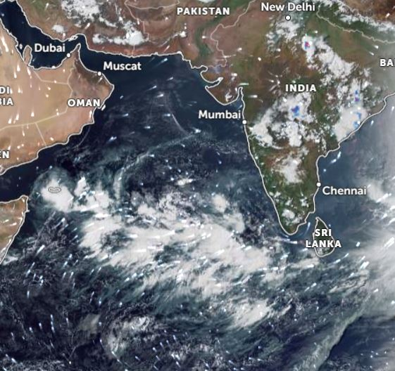
The outer bands of Cyclone Biparjoy have entered Pakistani coastal territory, stretching from Sindh coast to Balochistan coast. By now it is estimated to be about 470 km South of Karachi.
As evident from the satellite and wind charts, its size has grown with ‘tropical-depression’ equivalent windspeed (38-40+ mph) being recorded as far as 250-300 km from the eye of the hurricane. The catastrophic thunderstorms are south of the eye where 800+ mm of rain continues to fall in 24 hours as per NOAA radar. Wind gust around the center is diminishing to 105 mph.
We are maintaining our conclusive track published on 11th June, the area between Keti Bandar (Pakistan’s Sindh) to Porbandar (India’s Gujarat) remains the likely place where it can make landfall on June 14/June 15 (+1 day delay possible) as a high-end tropical storm or a category-1 hurricane. American GFS is once again showing a Karachi landfall however the scenario of it unfolding is low as GFS has been unreliable with Cyclone Biparjoy.
-Possibility of landfall remains ‘VERY HIGH’ for Indian Gujarat
-Upgrading from ‘HIGH’ to ‘VERY HIGH’ for Pakistan (SE Sindh).
It can enter Pakistani coastal territory by Monday late night or Tuesday late night before diverging NE/ENE. It will cause a short heatwave around 40°C to 42°C in Karachi, feel-like can be as high as 45°C/46°C till Tuesday/Wednesday. Chances of showers (at times heavy) with gusty winds (45 to 60 mph) on June 14/June 15 (+1,-1 day error) in the metropolis. Whereas, chances of tropical heavy downpours accompanied by stormy winds (60 to 90 mph) in Keti Bandar, Shah Bandar, Badin, Mithi and adjoining areas on June 14 to June 16.
11th June – 11:59 PM PKT
Rain around the center has exceeded 800+ mm in 24 hours. Winds gusting to 130 mph.
Cyclone ‘Biparjoy’ is 642.12 km SE of Karachi as it has moved in an NNE direction. It is maintaining a major category-3 hurricane status with a slight intensification trend.
A conclusive track has been established, with almost all models now agreeing that the area between Keti Bandar (Pakistan’s Sindh) to Porbandar (India’s Gujarat) is likely where the storm will make landfall on June 14/June 15 (+1 day delay possible) as a high-end tropical storm or a category-1 hurricane.
Under this influence, we have amended the possibilities of landfall to;
-Upgraded from ‘HIGH’ to ‘VERY HIGH’ for Indian Gujarat
-Upgraded from ‘MEDIUM’ to ‘HIGH’ for Pakistan
-Downgraded from ‘LOW’ to ‘VERY LOW’ for Oman.
It can enter Pakistani coastal territory by Monday late night or Tuesday late night before diverging NE/ENE. It will cause a short heatwave around 40°C to 42°C in Karachi, feel-like can be as high as 45°C/46°C. Chances of showers with gusty winds (60 to 80km/h) on June 14/June 15 (+1,-1 day error) in the metropolis. Whereas, chances of tropical heavy downpours accompanied by stormy winds (100+ km/h) in Keti Bandar, Shah Bandar, Badin, Mithi and adjoining areas on June 14 to June 16.
10th June – 11:59 PM PKT
On Sunday, the track will finalize!
Cyclone ‘Biparjoy’ has intensified into a category-3 hurricane, which is considered a major hurricane on the SSHWS scale. It lies 745 KM South of Karachi. Initially in the morning, the track shifted particularly towards Karachi’s coastal belt however we cautioned on Twitter that it is unreliable and subject to change. The conclusive track is likely to establish on Sunday. The latest numerical runs favour a landfall over Indian Gujarat on Wednesday/Thursday, with chances now increasing from ‘medium’ to ‘high’. For Pakistan they remain ‘medium’, the storm can still enter Pakistani territorial waters before diverging ENE.
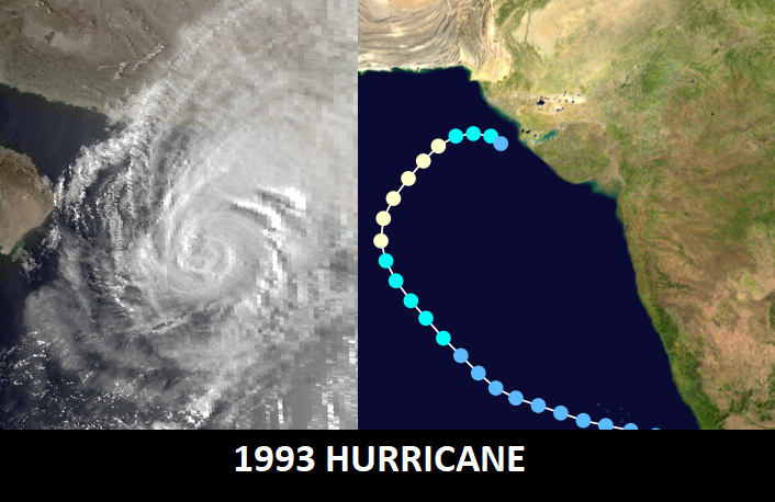
In Nov 1993, a category-1 hurricane was forecasted to make landfall in Karachi, not only it weakened significantly on approach but moved towards Indian Gujarat.
9th June – 11:59 PM PKT
Wait-and-see approach as Biparjoy continues to puzzle everyone!
By Sunday, the track should finalize!
Around the centre – NOAA’s satellite continues to show 700+ mm in 24 hours
Cyclone ‘Biparjoy’ lies 950 KM South of Karachi now! By Monday or Tuesday, there is a chance it will enter Pakistani territorial waters. For the time being, the possibility of landfall over Pakistan (Thursday/Friday) remains ‘medium’, with an equal chance of hitting Indian Gujarat (Wednesday/Thursday) or trailing over Pakistani waters towards Oman (.June 17/June 18).

Weak moisture incursion is being observed over Karachi and adjoining coastal areas. After the weekend, moisture levels can start increasing leading to high tides and an increase in clouds. Chances of intermittent showers accompanied by gusty winds along the Sindh coast on June 14/June 15 (+1,-1 day error). Depending on its position and track by Tuesday, if it’s closer to the coast, then there is a possibility of tropical downpours accompanied by stormy winds on June 14/15 (+1,-1 day error) but that is an “IF”. The reason is as it continues to divert from the forecast,;
- Today, It diverged from its NW/N track to an unexpected NE movement. There also was unreliability today when it came to its intensity.
- Pressure had increased to 986 hPA while JTWC briefly lowered it to a category-1 hurricane, minutes later rectifying it back to a category-2 hurricane.
- The easterly wind shear is subsiding, giving the storm a chance to re-organize itself thus the possibility of it intensifying into a major category-3 to 4 hurricane is valid till Monday/Tuesday.
- American GFS is showing an extreme rain anomaly (300+ mm rain) in Karachi next week. In the monsoon season of 2022, it was largely accurate. However, for Cyclone Biparjoy it hasn’t been correct so best to be cautious when using it this time.
8th June – 11:59 PM PKT
Biparjoy is proving to be a difficult storm to track, even by Arabian Sea standards!
Cyclone ‘Biparjoy’ is now moving in a completely northerly direction. It is 1105.61 KM south of Karachi. After a brief unexpected weakening due to wind shear, it is again gaining intensity, and the forecast of intensification to a category-3 or 4 will remain. We are not highlighting any tracks because they will alter after 6 hours. Expecting by Sunday or Monday, we should have a clear idea of where it will eventually make landfall. The storm will stay active throughout next week as well.
Weak moisture incursion was observed over Karachi and coastal areas as cirrus clouds were seen on the southeastern horizon of the city. Moisture levels can start increasing going into next week.
7th June – 11:59 PM PKT
Tropical storm ‘Biparjoy’ intensified further into a category-2 hurricane in the last 24 hours and it is now stationed 1227.92 KM South of Karachi. Continues to track in an NW/N direction. It can intensify further into a category-3/4 hurricane in 24 to 48 hours.
Repeating the same forecast as shared yesterday night, “Distance from the Pakistani coast will surely reduce but no threat for the time being. Currently, wind flow over coastal Pakistan is NOT showing any sign of being impacted by this particular cyclone. Westerlies continue to dominate much of Pakistan. As Biparjoy moves into the west central Arabian Sea, low-level moisture incursion might start taking place over coastal Pakistan including Karachi later this week from Thursday or Friday, increasing humidity but this is again an indirect influence and not a cause of concern.”
There is no agreement within numerical models as to where this storm will head. Huge variance continues to exist. The storm is likely to stay active next week as well.
6th June – 11:59 PM PKT
It is dropping 720 mm of rain in 24 hours over the Sea
Within 24 hours, low pressure rapidly strengthened into a tropical storm on the SSHWS. Now lies 1348.63 KM SSE of Karachi as it moves in an NW direction. It is currently a high-end tropical storm, expected to further intensify into a category-1/2 hurricane in 3 to 12 hours. It did gain intensity rather much before earlier than expected as it passes over the hottest waters in the Arabian Sea where the temperature is above 32°C.
(Clearly visible that it has deviated from JTWC track)
There is a possibility of it reaching category-3 or 4 massive hurricane status in 48 to 72 hours. It will continue to track in an NW/N direction in the next 2 days over open waters. After that, it’s still not certain where it will head (we have to wait 24 to 48 hours). Distance from the Pakistani coast will surely reduce but no threat for the time being.
Currently, wind flow over coastal Pakistan is NOT showing any sign of being impacted by this particular cyclone. Westerlies continue to dominate much of Pakistan. As Biparjoy moves into the western central Arabian Sea, low-level moisture incursion might start taking place over coastal Pakistan including Karachi later this week from Thursday or Friday, increasing humidity but this is again an indirect influence and not a cause of concern.
5th June – 11:00 PM PKT
Yesterday’s circulation intensified into a strong low-pressure area and moved in the ENE direction. Likely to move now in a NW to a rather northerly direction. The system is 1485.43 KM SE of Karachi, Pakistan.
- It is hovering over the hottest waters of the Arabian Sea where the temperature is above 32°C (extremely high for the sea). Hence, it is likely to intensify further into a tropical depression within 24 hours.
One thing that is consistent with numerical simulation since May 30th
is its intensity. This can be a major hurricane on the SSHWS scale, either
category 3 or category 4 hurricane. It is very unusual for a computer model to maintain such a forecast for a long period of time.
The track continues to alter ranging from Oman to Pakistan’s Balochistan to
Indian Gujarat and even dissipating over the western Arabian Sea due to strong wind shear. This is very normal for an Arabian Sea cyclone when it comes to their forecasted track. It will keep changing until it actually becomes a strong depression or a tropical storm so no need to pay heed to the track for now.
4th June – 5:00 PM PKT
On 30th May, a weak circulation formed over the southeast Arabian Sea near Kerala coast in India. Today it is about 1673.7 KM SSE of Karachi, Pakistan. It is likely to intensify into a low-pressure area in 48 hours and move in the NW direction towards the northern-central Arabian Sea.
Numerical models project it to become a cyclone during the end of the coming week or early mid-week of June. It is being projected to reach the intensity of a category-3 or 4 hurricane. No concrete track has been established yet.

Currently, the SST in the eastern Arabian Sea is 30°C while exceeding 32°C over the central Arabian Sea. With relatively stable winds, the formation of a tropical system is ‘very high’.
Related Posts and Updates
