
-
Rain coming in the North!
-
Islamabad, Lahore caught in fog
-
Karachi to see sun!
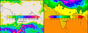
Comparing the winter temperatures of last year it is quite understandable that winter 2012 – 2013 has so far remained more closer to a warmer side as the precipitation has been low as well but they were more frequent than last year therefore reducing foggy conditions. However since some weeks Pakistan has remained dry, giving rise to dense fog over Lahore and other cities of Punjab. The last western system that brought country-wide rainfall was western disturbance ’11’ that also impacted the southern part city of Karachi where stormy winter rain came as an surprise.
Major factors affecting Pakistan
*A western disturbance ’12’ would reach the north-western parts by December 26 /December 27.
*Foggy conditions to prevail in the northern areas till 36 to 48 hours.
Punjab fog – there is a way out!
Lahoriites can escape this situation as a western disturbance ’12’ (winter weather system) is moving towards the north-western parts of the country. It would affect the north-western areas from December 26 night and could cause some showers till December 29 morning. Quetta and Peshawar are likely to witness some showers on December 26/December 27 after that Islamabad, Murree and adjoining cities would witness showers. The intensity is mostly weak to slightly moderate.
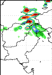
Where is Punjab in all this scenario? Well, there would be a partly/mostly cloudy period during this activity in Lahore, Gujranwala, Multan, Faisalabad and other surrounding cities however there are some chances of isolated shower in Sialkot, Gujranwala, Wah and Gujrat. Since Lahore is little eastwards therefore the city could experience light drizzle but many models do not agree on that.
South Punjab is likely to remain dry.
Most impacted cities!
The areas between Islamabad, Muzaffarabad (Kashmir), Abbottabad (Khyber Paktunkhwa), Saidu (Khyber Paktunkhwa), Kagan (Khyber Paktunkhwa) and Mardarn (Khyber Paktunkhwa) could get the most rain from this western system. Rainfall could be below 45 mm there.
As of December 26, there are chances that rainfall in this area could be around 50 mm.
Karachi is all dry!
Anything interesting is happening near Karachi, things are likely to stay dry at least till the end of 2012 however some clouds could occur during the period of western disturbance ’12’. Sindh province expected to remain dry as well.
Temperature to remain unstable
Temperatures this week would remain unstable as this would slightly rise (only by 1°C or 2°C) from December 26 till December 28 before another drop in day and night temperature would occur all over the country including Karachi from December 28 night.
Poll of the week
Pakistan Weather Portal (PWP) wants to know;

I would appreciate if you write an article on Sudden temperatures drops, there are a lot of examples and records of sudden temp drops around the globe, can u give some gentle idea why it happens and can it happen in any area of Pakistan?
sure thing, I would make an article on it.
PMD is forecasting ‘extreme’ cold wave from Friday(tomorrow) in the country…Whats your forecast? Will the minimum temperatures reach 0C in plain areas of upper Punjab?(Especially Lahore) like it did last year…
2 or 3°C could be the lowest temperature in Lahore while the highest could be around 15 to 18°C
lowest for Peshawar?..:P
4°C could be the lowest as Peshawar would remain under the grip of humid winds till 48 hours.
very cold. showering here in Gujranwala. will the showers continue in the night and can we expect sun tomorrow?
Its very cold here in Karachi (for our standards :D), last night fast dusty winds blew in Karachi. Gujranwala is under the grip of a cold wave which would stay tomorrow as well, from tomorrow morning the shower chances would drop but this would cause temperatures to decrease, so enjoy the chilly weather.
Thanks. good to hear cool weather in Karachi too. :)
Coldest Day in Lahore this winter, temperatures are 8C and its 2 pm… I’m loving it :)
That is amazing :)
below freezing point to be experienced by IsloO this winter or nOt ??
When is the next western disturbance expected that would bring rain in the north east punjab?
January 5 or 6, it remains weak.