
Updated on February 5!
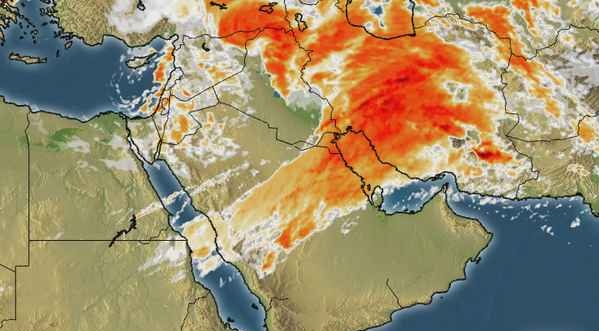
Western disturbance is over Middle East
-
”This is a major western storm”
-
“Rain from north till south”
-
“Flooding possible in the north”
The country has been under the influence of a warming trend as the temperature have risen in various parts of the country by 2°C to 4°C. The southern parts are also experiencing a similar condition. The winter storm is over Iran and adjoining Saudi Arabia, it has affected Iraq and Egypt where gust fronts and heavy flooding have been witnessed, it would now affect UAE and Oman. Clouds from this system would start affecting the country from tonight with slight chances of showers in the western and north-western areas and then an increase would occur. On February 3, it would have left the middle eastern countries and its main focus would be Pakistan. Following are the feature of this winter storm;
- Intensity – Strong
- Winds – 40 mph gusting to 45 mph
- Movement – NNE
- Duration – February 1 till February 6 (Pakistan)
Timeline of Western disturbance ’18’

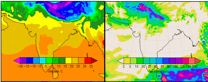
On the afternoon of February 2, Western disturbance ’18’ would be over NW Iran and adjoining Afghanistan by the same night, it would be over Iran-Afghanistan-Pakistan (north-western Balochistan). During that time, trough from this WD would be over western Balochistan extending till Makran coast with thunderstorms. On February 3, it would be over central Afghanistan but its trough would cover much of the country extending till Karachi coast. On February 4, the western disturbance ’18’ would be situated over northern areas of Pakistan while the thunderstorms over southern parts over Sindh including Karachi could move into Indian state of Gujarat. Western disturbance ’18’ would stay over the northern areas from February 4 till February 5 night where it would weaken on February 6 morning and start moving into north-western India where it would stay till February 7 before finally its clouds spreading and it would be much dissipated.
On February 4, weak cold winds may penetrate into the country especially the northern areas.
Northern areas – Torrential rainfall may occur!

During the first week of February (February 2 till February 6) some 120+ mm precipitation could in the areas of Muree (Punjab), Muzaffarabad (Azad Kashmir), Kalam (Khyber-Pakhtunkhwa), Besham Naran (Khyber-Pakhtunkhwa), Dasu (Khyber-Pakhtunkhwa), Saidu (Khyber Paktunkhwa), Kagan (Khyber Paktunkhwa) and Mardarn (Khyber Paktunkhwa)and other adjoining areas. Heavy snowfall/blizzard could occur over northern areas including Murree. During this period, rainfall of 50 mm to 75+ mm rainfall could fall in capital city of Islamabad with thunder/lightning and fast winds (50 km/h to 56 km/h).
While in Punjab especially north-eastern parts that are Sialkot, Jhelum, Gujrat, Gujranwala and Lahore – there could be rainfall with thunder/lightning along with fast winds. Rainfall of 60+ here as per latest analysis. The most heaviest precipitation could occur in the above mentioned areas.
Central areas – Moderate rainfall may occur
South Punjab that is Multan, Bahawalpur, Bahawalnagar, Rahim Yar Khan and adjoining cities may experience a light rain shower with chances of moderate falls (western areas of south Punjab have slight chances of isolated heavy rainfall) that would remain below 30 mm on February 3 till February 5 early.
Southern areas – Rain coming to Karachi?
The trough of Western disturbance ’18’ would pass through Sindh coast (covering much of southern parts) from the Makran coast bringing showers with chances of few moderate falls in Karachi on February 3, the rain in Karachi may below 20 mm. Third Winter showers is coming! What a winter! (whenever PWP forecasted rain in winter 2012-2013 in Karachi, it rained!)
There are chances of shower/rain with chances of moderate falls in other areas of Sindh that is western and upper parts (Dadu, Hyderabad, Thatta, Nawabshah, Sukkur, Larkana and other surrounding cities) on February 3 till February 4.
Update issued below
Updated on February 5 at 9:30 pm
Powerful Winter Storm Western disturbance ’18’ moving away from the country, the storm center has moved into extreme northern areas while few thunderclouds are over northern areas, chances of moderate rainfall with isolated heavy falls and strong winds till night in the these areas. Tomorrow the sky would start to clear up in these areas with chances of isolated rain till morning/mid-day, with each passing hour the storm is weakening.
A coldwave has also entered the southern parts and likely to extend into the northern areas from tomorrow morning. It has broken snowfall records while caused 200+ mm rainfall in few cities. Another weak WD ’19’ may affect during the coming week. It is highly weak when compared to WD ’18’.
Updated on February 4 at 10:30 pm
Powerful Winter Storm ’18’ continues to unleash widespread heavy downpour/blizzard to the northern areas of the country with strong gusty winds. Chirat got 148 mm, Saidu Sharif got 138 mm, Risalpur got 136 mm, Lower DIR got 107 mm, Islamabad got 69 mm rainfall, showers also occurred in parts of Sindh while Karachi got hail with heavy showers. Showers in Sindh occurred from the second wave of thunderstorms that formed after the first one left for India.
More severe weather conditions likely in the north as intense thunderstorms are present over north-western areas, the severe weather conditions to end by tomorrow night in the northern areas.
Updated on February 3 at 10:00 pm
Western disturbance ’18’ intensified again into a powerful winter system and now lies over eastern Afghanistan and adjoining north Pakistan, its trough is extending towards southern parts and would leave the southern parts and the Sindh coast including Karachi from late tonight. (On February 3, rain occurred in Hyderabad, Larkana, Sukkur, Jacobabad, Shikarpur and Dadu while light shower occurred in Karachi (6 mm)).
There is a strong thunderstorm forming over north-western parts of Pakistan that can bring some heavy downpour/snowfall to the northern areas. Rain at times heavy to continue in Islamabad with fast/strong winds. (Moderate rainfall has occurred in Islamabad, Peshawar, Quetta while snowfall occurred in Chitral and light shower in Lahore). From February 4, WD ’18’ main focus would be northern areas as it moves into the country, rest of the country would witness clear skies. Weak Cold winds are expected in the country from tomorrow.
Updated on February 2 at 10:30 pm
Powerful Western disturbance ’18’ has weakened after leaving Saudi Arabia, it has brought severe rainfall to the Arabian city of Jeddah where 111 mm rainfall has occurred while ten people have lost their lives.
According to PWP’s update issued on January 31, the western system as forecasted is over Iran-Afghanistan-extreme western Balochistan and likely to re-intensify into a powerful winter storm.
Poll of the Week
Pakistan Weather Portal (PWP) wants to know;
