
‘Another Arabian system moving towards Oman?’

Cyclones are very rare in this part of the world but the Arabian Sea does have some potential in giving birth to the strongest tropical cyclones of the north Indian ocean. The finest example being Cyclone Gonu, which attained a peak intensity of 920 mbar with winds of 160 mph gusting to 195 mph. Gonu is the strongest tropical cyclone on record in the Arabian Sea, and is also the strongest named cyclone in the northern Indian ocean,there are some studies that suggest that Gonu might have been the strongest cyclone of north Indian ocean since record began.
A new study has shown that there is a gradual increase in cyclones in the Arabian sea however now most storms in the Arabian sea move towards Oman or Yemen as compared to the earlier Pakistan or India.
Next name on the list?

 Phailin – It is a name contributed by Thailand, it is pronounced as ‘Pie-leen’ and it means Sapphire.
You might be interested in this article, A Cyclone is coming to Pakistan this year!
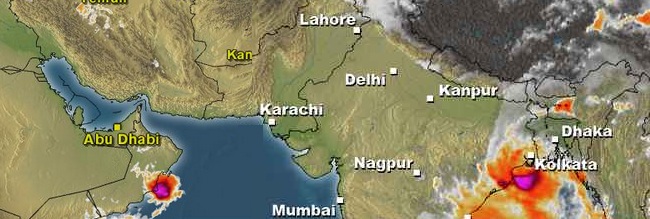
Tropical cyclone forming in the Arabian sea?
Pakistan Weather Portal (PWP) in its Weather Update Article on May 8 had said, “During late May, there is a slight possibility for the formation of a depression that it likely to travel till central Arabian sea after that its future is disputed.”
Chances of formation of a cyclone are very slim however there are good chances of a well-marked low/depression.
Expected History of the storm
Notice: Latest updates will be issued when necessary since tropical systems have high tendency to change their track and strength.
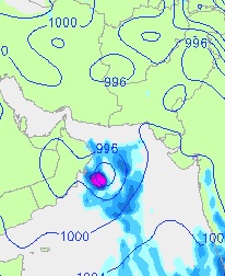
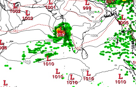
According to latest runs by few computer models show that the circulation that formed in the central Arabian sea has tracked westwards towards central coast of Oman and as of May 27, it has intensified into a low pressure area and lies off the coast of Oman. It is expected to move in a North/NW direction and during this period it may intensify further into a depression or even a deep depression as the pressure can drop till 1004 mbar/1000 mbar (GFS showing drop till 996 mbar) though it will remain close to the coast of Oman. During the last days of May/early first week of June, it will fizzle out over the north-eastern areas of Oman, some clouding may reach Makran coast and adjoining Sindh coast.
It is worth-mentioning that since the track of the system is away from the monsoon region (Pakistan and India) therefore any intensification of this storm above well-marked low pressure could be harmful to the monsoon advancement in the Arabian sea since ti will drag the moisture away. Moderate to heavy rainfall with strong winds 45 km/h to 60 km/h winds can occur in eastern and north-eastern areas of Oman during this period some drizzle/showers can occur in Makran coast and adjoining Sindh coast, they could be considered as pre-monsoon activity.
Another tropical activity?
Yes there are chances of another tropical activity in the Arabian sea after the first one dissipates. According to few computer models, during the mid week of June some thunderstorms from the Bay of Bengal might cross southern India to reach north-eastern Arabian sea. These thunderstorms would bring widespread monsoon rainfall to the west coast of India and from the same thunderstorms a deep depression or a cyclonic storm might form that could move till coastal Gujarat and having some affect on south-eastern Sindh during the mid week/last week of June.
Tropical Poll
Pakistan Weather Portal (PWP) wants to know;
