
![]()
-
Negative Indian ocean Dipole declared!
-
Lahore getting frequent rains
-
Karachi waiting for it’s turn
New Update issued Below from July 20 till July 31
Pakistan has turned into Monsoonistan as rains have moved into Pakistan, the only area of the country that continue to get proper rains is the northern areas that since the pre-monsoon activity in June is witnessing healthy amounts of rain while the central and southern areas continue to witness isolated events of rains however during the mid-week of July, some improvement was seen over the country, isolated rains occurred in Sindh and south Punjab while northern areas continued to witness almost daily thundershowers since July 6 though the activity weakened after July 10 before weakening strength on July 15 after a brief gap another monsoon spell is expected in the country.
Factors – Present Conditions
*Western trough ’13′ is over the northern areas of the country.aaa
*Low pressure over West Bengal, Odisha and adjoining Bay of Bengal persists.
*Upper air cyclonic circulation over Haryana and adjoining states of India.
Emerging Factors – Effect on Monsoon

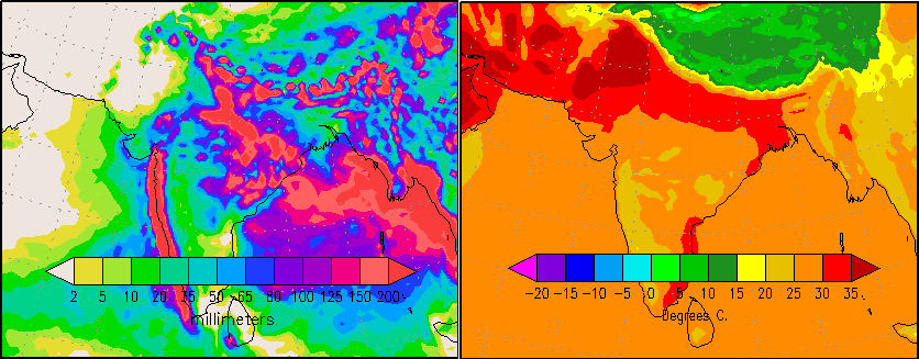
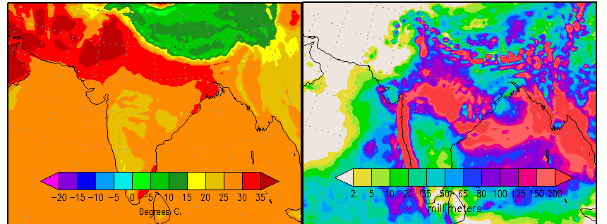
*INDIAN OCEAN DIPOLE – U.S Weather Agency since July 10 has declared Negative Indian Ocean dipole in the Indian Ocean while Madden-Julian Oscillation phase is also observed over Bay of Bengal and Arabian sea that can remain even during the third/fourth spell in the country. The sea surface temperature of Pacific ocean shows a slight cooling near the coast of South America which indicates towards weak La-Nina. In June, International weather Agencies hinted the possibility of formation of La-Nina later in the season.
*DUST CLOUD – Strong dust cloud presence over southern, moderate over central while weak over the extreme northern areas. There is no dust cloud cover over the northern areas as per today’s image.
Third Monsoon spell
On July 9, PWP mentioned the chances of third monsoon spell in the northern during the mid-week of July at ‘moderate’ and in coming days it was upgraded to ‘extremely high’, PWP also mentioned chances of monsoon activity in Sindh and south Punjab during the mid-week of July. On July 11, a date of July 15 (+1,-1 day error) was given for third spell in the northern areas. On July 12 night till July 14/July 15, weak monsoon activity was observed in Sindh and south Punjab, following are the total rain recorded for Sindh and South Punjab during that period;
- Mithi got 38 mm.
- Bahawalpur got 25 mm – South Punjab
- Chhor got 10 mm.
- Badin got 14 mm.
- Padidan got 14 mm.
- Thatta got 5 mm.
- Nawabshah got 8 mm.
- Karachi 2.1 mm
- Hyderabad got 1.7 mm
Since the third spell has just started in the northern areas therefore the highest rain recorded during the third spell (July 15 till July 17/July 18) will be given after the spell ends.
North – Rain, rain and rain

This spell which started from July 15 can continue till July 17/July 18. During that period, chances of rain with thunder/lightning in Islamabad, north-eastern Punjab (Lahore, Rawalpindi, Murree city, Jhelum, Gujrat, Faisalabad, Sialkot, Norwal, Sheikpura, Gujranwala, Attock, Mandi Bahauddin and few adjoining districts), Khyber Pakhtunkhwa (Abbottabad, Manshera, Haripur, Swabi, Swat, Peshawar, Landi Kotal, Hangu, Kohat, Khyber Agency, Khurram Agency and few adjoining districts) and Azad Kashmir (Muzaffarabad, Kotli, Mirpur and few adjoining areas with chances of isolated heavy falls).
The third spell which will continue till July 17/July 18 is weaker and isolated when compared to the second spell.
Central Areas – Missed thunderclouds!
South Punjab despite witnessing almost daily weak thundercloud formation near it, has not reported any traces. Partly/mostly cloudy with chances of drizzle/isolated shower in South Punjab (Bahawalpur, Bahawalnagar, Rahim Yar Khan, Vehari, Dera Ghazi Khan and adjoining areas).
Due to the advancement of western trough ’13’, north-eastern parts of Balochistan and adjoining south Punjab has witnessed daily formation of thundercloud since July 15, partly/mostly cloudy with chances of Zhob, Musa Khel, Bharkhan, Dera Bugti, Qila Saifullah, Loralai and few adjoining districts of Balochistan.
South – Under cloud cover
Chances of drizzle/isolated shower in parts of Sindh (Karachi, Thatta, Tharparkar, Mirpur Khas, Umerkot, Badin and adjoining areas) while passing clouds (increase during night/morning) in Sanghar, Khairpur, Sukkur, Gotki and adjoining areas,
Chances of showers in parts of Balochistan (Khuzdar, Awaran, Panjgur, Lasbella, and few adjoining districts), thundercloud activity for past days has been observed over these areas as well.
Fourth Monsoon spell

In PWP’s monsoon update of July 13, it was mentioned that fourth monsoon spell can start after the third spell, the fourth spell has a better coverage. On July 16, PWP gave a date for the fourth monsoon spell in the northern that is July 20 (+1,-1 day error).
During the fourth spell, northern Punjab, Azad Kashmir and parts of Khyber Pakhtunkhwa can witness heavy rain with chances of isolated very heavy rain in northern Punjab and adjoining Azad Kashmir while coastal areas & adjoining south-eastern parts of Sindh and North-eastern Balochistan & parts of south Punjab can witness light showers as per some models, no chances of proper rains yet in Sindh and south Punjab.
- Pakistan Weather Update will be updated once the third monsoon spell ends
Pakistan Weather Update & Monsoon Alert (July 20 – July 31)
-
Fourth Spell is bringing heavy rains to North
-
Fifth Monsoon spell seen for North
-
Wet week ahead!
Pakistan especially the northern areas are under the grip of monsoon rains after the end of third monsoon spell on July 18, the northern areas saw the strongest monsoon spell (fourth spell) of the season from July 20.
Factors – Present Conditions
*Western system ’14’ over the northern areas of Pakistan.
*Upper air cyclonic circulation over Indian Punjab another over north-east Madya Pradesh and adjoining north Chhatisgarh and south-east Utter Pradesh.
*Low pressure over north-western sector of Bay of Bengal.
Recap of the Third Monsoon spell
On July 9, PWP mentioned the chances of third monsoon spell in the northern during the mid-week of July at ‘moderate’ and in coming days it was upgraded to ‘extremely high’, PWP also mentioned chances of monsoon activity in Sindh and south Punjab during the mid-week of July. On July 11, a date of July 15 (+1,-1 day error) was given for third spell in the northern areas. On July 12 night till July 14/July 15, weak monsoon activity was observed in Sindh and south Punjab, following are the total rain recorded for Sindh and South Punjab during that period;
- Mithi got 38 mm.
- Bahawalpur got 25 mm – South Punjab
- Chhor got 10 mm.
- Badin got 14 mm.
- Padidan got 14 mm.
- Thatta got 5 mm.
- Nawabshah got 8 mm.
- Karachi 2.1 mm
- Hyderabad got 1.7 mm
The highest rain (above 40 mm) recorded in the northern areas during the third spell (July 15 till July 17/July 18) is as follow;
- Risalpur got 101 mm – Khyber Pakhtunkhwa
- Lahore got 55 mm (Mirsi Shah Reading) – Punjab
- Islamabad got 46 mm.
- Parachinar got 46 mm – Khyber Pakhtunkhwa
- Jehlum got 43 mm – Punjab
- Kakul got 45 mm – Khyber Pakhtunkhwa
- Mianwali got 43 mm -Punjab
- Dir got 40 mm – Khyber Pakhtunkhwa
The third monsoon spell started from July 15 and ended on July 18. Weak western trough ’13’ was also present during that period. After 24 hours, fourth monsoon spell hit the northern areas, it was also facilitated due to a western system – western disturbance ’14’.
Fourth Monsoon Spell
On July 13, PWP talked about the fourth monsoon spell right after the third spell, in the following days the chances of the fourth spell was upgraded in the northern areas. On July 16, PWP gave a date for the fourth monsoon spell that was July 20 (+1,-1 day error) and told that the spell has the potential to cause isolated very heavy downpour in parts of northern Punjab, Azad Kashmir and Khyber Pakhtunkhwa.
The spell started on July 20 with scattered heavy downpour along with isolated very heavy falls, following is the rain recorded (above 40) on the first day of the spell;
- Islamabad got 217 mm.
- Gujranwala got 130 mm – Punjab
- Sialkot got 111 mm – Punjab
- Rawalakot got 61 mm – Azad Kashmir
- Gujrat got 59 mm – Punjab
Northern Areas – Fourth Monsoon is significant!

“Alert: Scattered heavy rain likely in northern areas of Punjab, some parts of Azad Kashmir and few parts of Khyber Pakhtunkhwa”
Rain at times heavy and thunder/lightning in Islamabad, northern Punjab (Lahore, Rawalpindi, Murree city, Jhelum, Gujrat, Faisalabad, Sialkot, Norwal, Sheikpura, Gujranwala, Attock, Mandi Bahauddin and few adjoining districts), Khyber Pakhtunkhwa (Abbottabad, Manshera, Haripur, Swabi, Swat, Peshawar, Landi Kotal, Hangu, Kohat, Khyber Agency, Khurram Agency and few adjoining districts) and Azad Kashmir (Muzaffarabad, Kotli, Mirpur and few adjoining areas). There are chances of isolated very heavy rainfall in northern areas of Punjab and few parts of Khyber Pakhtunkhwa (Kurram Agency, Khyber Agency, Orakazi Agency, Kohat and adjoining districts) and some parts of Azad Kashmir (Rawalakot, Mirpur, Kotli and adjoining areas)
Central Areas – Passing clouds with hit-or-miss light showers
Since last few days thunderclouds are forming over Rajasthan and dissipate upon entering south Punjab while the western moisture causes thunderstorms to form over NE Balochistan under that influence partly/mostly cloudy with chances of drizzle/showers in some parts of South Punjab (Bahawalnagar, Bahawalpur ,Vehari, Dera Ghazi Khan and few adjoining areas).
During that period chances of showers/light rain in parts of Balochistan (Barkhan, Dera Bugti, Musa Khel, Zhob, Qila Saifullah, Loralai and few adjoining districts).
South – By least drizzle/isolated shower can occur!
Mostly dry weather as circulations are away from Sindh at the moment. Few clouds have been crossing into Sindh with some intensifying into a weak thundercloud. On July 20/July 21 chances of drizzle/showers in parts of Sindh (Karachi, Thatta, Tharparkar, Mirpur Khas, Umerkot, Sanghar, Khairpur, Badin and adjoining areas) while passing clouds (increase during night/morning) in Sukkur, Gotki, Jacoababad and adjoining areas.
Showers/light rain can occur in Khuzdar, Awaran, Panjgur, Lasbella and adjoining districts of Balochistan. Coastal areas of Sindh including Karachi has been witnessing daily drizzle since July 13, following are the rain stats;
- July 13 – 0.1 mm (Airport)
- July 14 – 0.1 mm (Airport)
- July 15 – 2.1 mm (Defence)
- July 16 – 0.1 mm (Airport)
- July 17 – 0.1 mm (Aiport)
- July 18 – 2 mm (Airport)
- July 19 – 3 mm (Defence)
Fifth Monsoon Spell
The fourth monsoon spell can weaken by July 22/July 23 in the north and in the coming week another monsoon (fifth monsoon) can aim towards the northern areas. PWP has observed some variation in the concentration of heavy rains in the fifth monsoon spell as COLA and GFS T574 shows the focus of heavy downpour in lower half of north Punjab that is Okara, Kasur, Sheikhpur, Faisalabad, Pak Pattan and few adjoining areas, COLA (not GFS) also shows light to moderate rains moving into south Punjab while on the other hand, US Charts shows (similar to past spells) concentration of heavy downpours over Islamabad, northern Punjab, Azad Kashmir and few parts of Khyber Pakhtunkhwa.
COLA and GFS (different version) show a low pressure moving towards Sindh during the last days of July and bringing heavy rains to much of Sindh including Karachi.
- Pakistan Weather Portal (PWP) will look into the fifth monsoon spell once the fourth spell ends!
Poll of the Week
Pakistan Weather Portal (PWP) wants to know that;

No rain this july !
GFS still shows rains during the last days of July..
I want to say some words about sindh weather..
Unlucky,miserable,hopeless,unfortunate,
LOL! Oh wow! Waseem Bhai don’t get so upset :)
Yes very unlucky..
friendly word for Waseem ahmad ………….Lolz
hahaha dont get much exited just for word as a joke
Oh my! Loved this article! Terse yet accurate, good job! I really wish South Punjab, Sindh and eastern parts of Balochistan recieve some rain because just looking at the heat indices there makes me feel hot! Interestingly, rains reached Jhang and parts of central punjab but missed poor Faisalabad.
Thank you :)
Faisalabad is missing rains while Peshawar is missing rains in KPK
Babar bhai Mirpurkhas City m heavy Rain kb hogi plz kuxh clear kar dein…!
Sorry buddy not till some days.
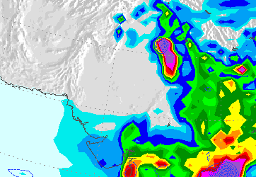
The empty pocket in northern Pakistan in the Dust Cloud today, is exactly what helped cause the floods in 2010, where the monsoon moisture from India got stalled in the pocket. It will be interesting to see if the pocket persists, and if it stalls the monsoon again, because today’s Dust Cloud pocket looks identical to the pocket that formed on July 18, 2010, that you can see at http://www.ecoseeds.com/2010071818_g.GIF
I hope that the floods of 2010 doesnt repeat..
Nice article.It is raining daily here.As I live in the northern area of Islamabad we get frequent heavy showers.As Margalla Hills became a barrier for heavy,dark rain laden clouds stopping them going north.What will happen in Khaur and Islamabad.
Getting news that there is thunderstorm near Islamabad.
Bro, can u plz issue forecast for Lahore during coming weekend?
Lahore forecast is mentioned till July 18 and once the third spell ends ill mention the fourth spell.
GFS not showing rain in Sindh now.
Like I said.
There is a model CFS that doesnt show proper rains till the end of August. COLA predicts light intensity rain.
This monsoon will be a disappointment.
Babar Bhai Risalpur is getting heavy rain since two days. Are there chances of more rainfall in the fourth spell in Risalpur?
As per PMD yesterday it was 71 mm and today early morning 101 mm was recorded. Yes there are chances of rain during the fourth spell as well.
Low moving westwards ?
Yes it has move westwards as it moves into central India.
when rain began in bahawalpur
Dissipating thunderclouds are moving towards south Punjab from India, chances of drizzle/isolated shower.
when rain begin in bahawalpur
when will proper rains come in south punjab
Proper rains are not seen till many days.
Is there any chances of rain in Jand, dist Attock..We have seen clouds a lot but no heavy rain this moonsoon
Yes there are chances of rain with thunder/lightning, at the moment, at the moment some weak thunderclouds are forming over KPK province.
Dear Babar, AoA,
Behtar tou yahi hai k aap apne portal ka naam ‘Pakistan’ k bajaye ‘Punjab & KPK’ portal rakh len coz sindh aur KHI k liye aap k pass koi good news nahi…agar hai sirf yahi ‘Dissipating cloud, dust cloud, weak low, cloud cover etc etc etc :( :( :( :( :( :(
Walikum Assalam,
When there is no major activity expected in those parts then what should I post about them! the pattern is active in KPK and North Punjab.
As per -IOD, there would be less rains in the subcontinenet but what we havee seeing is totally opposit, India men theek thaak barshen ho rahi hen even pakistani punjab aur KPK men bhi hoi hen tou phir how we can say that theory of -IOD is accurate?
I have mentioned to someone in the past as well just take the example of El-Nino the whole country got below normal rains while coastal areas got above normal rains. KPK and north Punjab are getting boost from western winds.
when you will make new monsoon article? please make the monsoon article today.
Monsoon VII will not be published anytime soon as there is no need for it.
& Lastly Babar, what about your every 2 year Cyclone myth?
3 year myth that started from 1998 and continued in 2010, lets see if the myth is trusty as we still have September, October and November
@KM :
GFS showing the current low near Sindh on 22nd :
I think no proper rains expected during that time. GFS is more certain about last week of July, its just postponing the rains..
And it is shows the future low pressure moving towards central India on july 25th :
Yes, GFS showing rains from 27th july till 3rd august.
@KM :
Look at this, GFS showing the current low entering Sindh from 22nd :
If this comes true then we could see heavy rains in Sindh. :D
And just look at the power of the future low pressure Babar bhai :D
Yes the GFS is showing widespread monsoon coverage over the sub-continent during the last days of July but it shouldnt be trusted right now :P
I dont think so that heavy rains can roll in right now in Sindh around July 22.
Well, At first GFS was showing the low pressure moving towards Utter Pradesh. Now it’s showing the low entering Sindh on 22nd :D
@KM :
FINALLY :D
Wow!!! Heavy downpour in coastal Sindh according to that :D
YESSS I can’t believe GFS is showing it. O_O
@KM :
I can’t understand what do these mean :
precip_06 precip_12 precip_24 precip_48, Do these represt hours ?
I share precip_48 model images with you.
represent*
Yes it represent the precipitation after like 6 hours, 12 hours and so on.
Finally a good news for Karachi, I hope it doesn’t change :)
Insha’Allah we will see heavy rains from the last week of july and continue till 5th august :)
But do remember that it is GFS :D in June it had showed 200 mm rain in Karachi as well in one of its run.
:D
It wasn’t GFS’ fault, Nature had other plans :p
Maybe we would get our share now :)
monsoondata follows gfs ?
It follows COLA, it shows rains after 24/25.
YES !
COLA and GFS are somewhat similar.
COLA is better, it doesnt change that much as compared to GFS
They have 1 forecast in common, no rain in Karachi :D
Well, COLA is also showing heavy rain in Karachi from 26th-3rd aug.
COLA showing 80-100mm in SIndh
GFS showing another low pressure forming around 31st in the BOB and moving westwards :O
@KM :
Heavy lightning in the SE. It started 10 minutes ago and is still going on. Is it visible in your area ?
Now it stopped.
The sky was mostly clear here..with some clouds in north direction.
For the People of Karachi. Good News!
http://www.weather.com/weather/tenday/Karachi+PKXX0008:1:PK
Rain expected in Karachi on 27 and 28 July as per this forecast.
Thank you Imtiaz..
Well well Guys, Tarim & Babar, thank you for leting us know some positive and good news….finally. I recently saw weather report on pTV where PMD Director Muhammad Hanif have said k 20th k baad but jald pore mulk me rain coverage increase ho gi aur sindh aur KHI men achi barish ho gi & i fully belive k that will happened.
Last days of July can see some rains..before that that daily pattern of drizzle/isolated shower can continue in Karachi
Test
Tell me plz about the rain of swabi,kpk?
Chances of rain during the fourth spell..
GFS showing absolutely no rain in Karachi now.
GFS will keep changing :P as always..
Why does it change SO MUCH ? :S
I mean last night it was showing heavy rains in Sindh and now its showing no rains.
Weather keeps changing and semi-desert areas have more unstable weather pattern than a tropical one.
GFS changes once the weather changes, this is mother nature!!
No rain this july :)
Yes now GFS has postponed the rains till August :P
Then it will postpone it till mid aug then last week of aug then september then mid september then it will show no rains.
Hahahaha..It has been doing this since the last week of June.
Yes like I said, This monsoon is going to be a disappointment.
Central India is covered with thunderclouds.
The low pressure has formed early hasn’t it ?
Yes it has formed early.
We won’t see any rain in july if this low doesn’t come to Karachi.
There can be another low pressure in the coming week as well but late.
hahahaha wow GFS is accurate indeed. Now let’s see what COLA has for us.
Like I said, COLA and GFS are similar.
GFS showing heavy rain again but this time I dont trust this until it really rains.
It looks like a well-marked low :
Today, the Dust Cloud is very strong at the India-Pakistan border keeping the rainfall stalled in India, except for the pocket in the north of Pakistan, that you can see at http://www.ecoseeds.com/dust-7-19-13.png and you can see the battle between the Dust Cloud and the monsoon rain clouds at http://www.ecoseeds.com/clouds-7-19-13.png
Rain with dark clouds in Lahore right now (12pm).
That thunderstorm that brought significant rains to northern Punjab and Islamabad is now dissipating.
In mumbai monsoon wind is directly proportional to sea breeze but in karachi sea breeze is inversely proportional to monsoon wind in summer.
AOA babar bahi.Mai nai zadah tur logo sai yehi sunah hai kai mumbai mai barish sea breeze ki wajah sai hoti hai.Hatah kai yeh jawab sahi nahi hai.mumbai mai barish south western monsoon wind hi ki wajah sai hoti hai.bus difference yeh hai kai waha sea breeze west sai aahti hai tau monsoon wind bi south west sai hi aahti hai.Aur woh sea wind kai relative move kurti hai ais liyai mumbai mai baarshai bi zadah hoti hai .Aur karachi mai yeh condition reverse hai.yehi wajah hai kai south western monsoon wind waha zadah barish ka cause bunthi hai.Pur north eastern wind (postmonsoon season) mumbai mai barish ki aitni zadah wajah nahi buntah as compared to premonsoon season.kyun kai north eastern wind ki direction reverse hojathi hai sea breeze kai. jaisa kai karachi mai hotah hai.Baqi karachi aur mumbai ka temperature same hotah hai. waha bi sea breeze mumbai kai temperature ko maintained rukhti hai karachi ki tarah.pur monsoon season aahtai hi mumbai mai temperature aur humidity increase honah shurooh hojati hai.Aur sea condition bi rough hojati hai.Ais liyai waha kai fisherman bi may kai aakhur mai apni activities close kur daitai hai.
Since last one hour, 47mm of rain has been recorded by PMD in Lahore. Rain still going on!
The monsoon trough runs through Mumbai’s coastline that’s why they get heavy rains in the monsoon season.
Dust cloud is similar to last year. It is still strong and not showing any signs of weakening.
With this negative indian dipole, there will be no more rain, or, would monsoon weaken because of this??
Is there a 5th spell expected in northern areas? 4th spell is by far the strongest.. :)
Negative IOD causes cooler sea temperatures in the western Indian Ocean which causes less precipitation in the Subcontinent.
Hmm thanks but I have to ask, since I dont even know the alif be of geography, what countries (or is it a part of a country??) are the subcontinent??
Pak + India = subcontinent
Indian subcontinent includes India, Pakistan, Bangladesh, Nepal, Sri Lanka etc.
SO, the entire subcontinent receives it’s rainfall from SW monsoon. -IOD weakens the SW monsoon which results in less precipitation in the Indian subcontinent.
Ok thanks, that was very helpful :)
Tarim i also say the same thing which you repeat.Monsoon enter in the mumbai through coast line which is lie in the west direction.This condition is not coincide with karachi and also opposite of karachi.you also remember this tarim north eastern monsoon are not too much responsible for rain in mumbai.normally 72mm is average.The colour of the cloud is also black which is come from the west direction like karachi,But this is the monsoon cloud not the sea breeze cloud which people cannot understand.
north eastern monsoon wind direction is opposite to the sea breeze in mumbai as similar to karachi.Therefore not too much rain is occur in mumbai .In the karachi stratus cloud which is the sea breeze cloud come from west direction and monsoon wind is come from north east.But my experience is that karachi get a rainfall similar to mumbai. if monsoon come from south west direction.In mumbai sea condition is also rough when monsoon come from south west. sea breeze help a monsoon to enter in the mumbai not resist monsoon like karachi.
If the monsoon trough ran through Karachi’s coastline like Mumbai then we would we seeing monsoon clouds coming from SW direction like Mumbai.Monsoon clouds come from E/NE in Karachi via Bay of Bengal.
Insha’Allah we would see a good rainy week ahead :)
http://www.timeanddate.com/weather/pakistan/karachi/ext
@KM :
I think ocean temperature is warming slowly.
Variation would be seen after the end of July. And yes GFS again shows heavy rain :)
weather channel is showing good rains from 28th july in sindh? is it right?
Yes
Tarim yes now you are right.
Babar bhai, Is there any Chance for Jand Attock, No proper rain yet
There are chances in Attock district at the moment, clouds are weakening, by late night fresh thunderclouds can form.
is there are high chances of rain in south punjab.
Not high chance yet. Will upgrade them if necessary
Babar Bhai and Tarim bhai, i`m also very much interested in weather since my childhood but i dont have much knowledge to read graphs or maps which you people talk about like GFS & COLA. I daily search about weather on different sites many times a day. i Found your site 2years ago when i was randomly searching for monsoon and found your site :)
Anyone who comes on this site is interested in weather :P
Great :D This is the best weather blog !!!
I’m happy to be a part of it :)
Same here :D
plz pray for sindh rains .still no rain …day by day we specially people of sindh loosing hope of monsoon rains .A khuda humary gunah maaf farma aor hum pr apni rehmat barsaaa.
Ameen.
@KM :
COLA showing heavy rains from 28th – 5th aug.
It’s showing 200mm rain in Khi. :D
Yes indeed, GFS shows some 80 mm rain from last days of July till first week of August.
While COLA shows 100 to 125 mm rain from last days of July till first week of August.
The rain stats will change tomorrow which is normal :P
it will change 21 times till august 27th :D
Hahahaha true that :D
wao great yar
nice to see the rains to come in karachi….
but babar bhai is not updating the current blog which is till july 31.
This article has been updated today.
but karachi rain prediction in july end is not mentioned
Fifth monsoon heading
got it… thank you…
Hope for the better
any update of -IOD? when it will start weakening
Can continue till mid august.
It is expected to remain till the end of monsoon season, it can be balanced in late August/September due to expected formation of La-Nina
Can we see La-Nina in 2014 ? :p
I cant say anything about it right now. Sub-continent hasnt seen an El-Nino in a while, the last chance erupted in 2012 but it didnt mature up.
@KM :
Are there chances of this low pressure intensifying into a well-marked low or even further ?
Yes there is a possibility of intensifying into a well-marked low.
AOA. Babar bhai very little rain occured in Risalpur on 20 july. Is there Chances of heavy Rain in Risalpur?
Walikum Assalam,
Chances of rain persists however no major chances of heavy rain in Risalpur, mostly moderate.
how much rain u can see in tharparkar district in coming days also in sukkur city
As per charts, no measurable rain seen for Sukkur while in the coming week, 1 to 10 mm rain is seen in Tharparakr.
Why is the weather clear in Karachi now ?
Yes, the sky is clear. It had been drizzling since July 13, it appears the moisture has run out, from coming week again the moisture will build-up leading to increase in SW clouds. Since the last 48 hours, the SW winds are weak while high level NE winds continue to be active.
I think that’s a good sign isn’t it ? :)
Well sort of, it does happen in Karachi after many days of cloudy weather.
In 2011, a well-marked low pressure system brought extremely heavy rains to Sindh remember KM ? :o
Yes, it was series of severe low pressures. In July 2011, UAC brought first rain to Sindh including Karachi :P remember that?
Yes july 26 :D
The low pressure formed on 20th july then why would it start moving inland on 27th ? :s
It persists over the same area, GFS shows intensifying and moving inland from July 25.
PWP, in the 4th spell, we got one night of awesome rain on friday night. Last night, the clouds looked dark and very heavy as if ready to burst but there was no rain. Tonight, there are weak clouds, light in color, , is there chance of more rain or will we have to wait till 5th spell?? This 4th spell ended very early didn’t it??
I am asking about Jalalia btw.
Thanks.
No chances of heavy rain in the North as the 4th spell has weakened significantly.
Isolated rain/thundershower can occur.
2009 please come back to Karachi on july 28th :D
@KM :
GFS is showing a delayed arrival of the low pressure in SIndh now.
Yes it has postponed the rains till August.
Like I said
Is there any chances in swabi,kpk next spell and when will started the next spell in swabi?
Is there any chances in swabi,kpk next spell and when will started the 5th spell in swabi?
There are chances of showers/rain
AOA..Babar bhai bahawalpur me kab rains start hon gi..
Walikum Assalam,
After mid of this week, there is a possibility of light to medium intensity rains in South Punjab.
Sir a very good article.Is the coming week good for transplanting trees and other plants in Khaur Company please tell.When will very heavy rains hit Punjab.What will happen in Islamabad.
Thank you Sardar, about plants you should ask a gardener.
Fourth spell had the potential to drop very heavy rains as it did on its first day but due to the unexpected quick movement of WD 14 the intensity dropped significantly. There are chances of isolated heavy falls during fifth spell.
The weather is good enough for plantation.
:( ;( ;(……. roote hen sham sham haaye re….Moonsoon Bewafai kar gaya re…… ;( ;( ;(
Mark my words both Tarim & Babar, agar is moonsoon men KHI men proper rains na hoin tou phir Sep/Oct ya NOv men Cyclone formation confirm hai….you will see that soon.
You mean just like in 2004.
I’m sure no one wants that, neither do I or Babar bhai.
We just want a wet monsoon season for Karachi and Sindh.
i thk Cyclone Onil returns :) .. leken me sure ho july k ends se khi me ache barishe hogi leken spell weak hoga 2 or 3 days then early september me formation k chance hia cyclone k ;)
I still have faith in the upcoming low pressure. Insha’Allah it will bring heavy rains to Sindh.
Its a strong well-marked low pressure now.
Weather.com hasn’t changed it’s forecast for Karachi since july 19th :
http://www.intellicast.com/Local/Weather.aspx?location=PKXX0008
wunderground.com updates in every 6 hours ;)
Did you understood what I said ? :p
Good to know that the low has intensified into an “intense” well-marked low :D
GFS, GFS (T574) and COLA shows the low pressure moving towards Sindh :)
GFS is still postponing the rains..
Hope you guys get some well deserved rain insha’Allah.
Ameen :)
Another UAC has formed over Northern Chattisgarh. Could it merge with the well-marked low ? :p
It has moved westward over East Madya Pradesh, I think the low will stay over NW Bay for some more time.
Dust Cloud still at the India-Pakistan border, and you can see the monsoon stalling and producing unusual heavy rains in spots over India at http://www.imd.gov.in/section/nhac/dynamic/Monsoon_frame.htm
Yes Tarim, i totally agree wid you k low will definitely move towards sindh as PMD forecasting it as well……. Lagta hai moonsoon PWD ko dodge de de ga aur PWD prediction sindh k bare men ZERO ki ZERO he rahe gi aur Babar agar aisa hua tou phir aap k uppar Penalty ho jaye gi aur wo bhi mazedar kisam ki :D
PMD hasnt forecasted anything about Sindh yet, they believed that proper rains would occur on July 21/July 22 period in Sindh and that didnt happen, PWP in Monsoon of Pak said that isolated showers can occur during that period. Also its *PWP and please read the article completely, PWP has forecasted the possibility of rains during last days of July. PWP’s forecasted the pre-monsoon activity in Sindh it did occur, mid-week of July some showers were forecasted by PWP in Sindh, they occurred. In second week of July, a weak spell occurred in Sindh that was missed by PWP.
Its not anyone’s fault Sindh and Baluchistan are dry areas.Look at these figures
Karachi 6.6 inches
Quetta 10.3 inches
Hyderabad 6.8 inches
Nawabshah 4.4 inches
Sibi 5.6 inches
Jacobabad 4.3 inches
Dalbandin 3.1 inches
On the other hand KPK ,North Punjab are wetter
Murree 70.4 inches
Islamabad 59 Inches
Dir 57 inches
Abbottabad 48 inches
Peshawar 16 inches
Lahore 19.3 inches
Its not the Monsoon its the natural climate.
66mm average rain in the month of july and we still haven’t seen it last week of july is here now lets wait and see.
The rains are below average and rain is always sporadic over Sindh and Balochistan. The averages don’t represent much because either it rains too much or it doesn’t at all.
Islamabad on the other hand is not 59″ of rainfall. it is roughly 1200 mm at zero point which equates to 47.2″
You can read my article The Dust Cloud that eats Cyclones and causes Droughts and Floods at http://www.ecoseeds.com/dust-cloud-eats-cyclones.pdf