
Quick Summary
This year’s spring season has brought certain meteorological volatility to Pakistan. This period was characterized by frequent non monsoon rainfall, gale force winds, and a significant thermal suppression that resulted in the coolest April for Karachi since 1985. Driven by a rapidly developing El Niño transition phase, these anomalies included a historic 97 mm deluge in Nazimabad and rare southern hailstorms. These events are the result of intensified extratropical storms known as Western Disturbances. While local speculation has attempted to link these shifts to regional military conflicts or neutralized weather-modification projects, scientific data and long-range numerical models confirm that the events are entirely natural. They mirror the high volatility climate patterns seen during the wet spring of 2024. Ultimately, this season serves as a powerful example of how ENSO cycle transitions can fundamentally reshape regional weather by overriding seasonal norms with intense atmospheric instability.
The spring of 2026 has brought significant meteorological anomalies to Pakistan, characterized by frequent extratropical storms, persistent non-monsoon downpours, and a distinct suppression of the early-summer heat. To understand these drastic shifts, PWP is looking toward the Pacific Ocean and the broader mechanisms of the El Niño-Southern Oscillation (ENSO) cycle.
Introduction: Understanding El Niño and ENSO Transitions
El Niño is a naturally occurring climate pattern defined by the abnormal warming of sea surface temperatures in the central and eastern equatorial Pacific Ocean. As a key phase of the broader ENSO cycle, El Niño fundamentally alters atmospheric circulation, displacing jet streams and shifting global weather patterns.
For South Asia, a mature El Niño typically suppresses the summer monsoon, leading to drier and warmer conditions. However, it is during the transition phases, when the cycle moves from ENSO-neutral to a developing El Niño, or vice versa, that extreme atmospheric volatility often occurs. During these transition windows, the Middle East and South Asia (MENA/SAARC regions) frequently experience an increase in high-frequency Extratropical Storms (ETS), locally known as Western Disturbances (مغربی ہوا). In the spring of 2026, a rapidly developing El Niño has catalyzed precisely this type of instability across Pakistan.
The Main Impact: Karachi’s Unprecedented Spring
The effects of this shifting global climate index have been felt acutely across Pakistan. Taking the example of Karachi, typically bracing for rising temperatures and arid conditions by March and April, the city instead faced a series of severe weather events.
- Severe Wind and Storm Systems: The volatility began notably on March 18, 2026, when a powerful ETS lashed Karachi with gale-force winds peaking at 97 km/h. This marks the highest official wind speed recorded in the city since Cyclone Yemyin in 2007, which brought winds of 111 km/h. The storm caused structural concerns and brought unexpected localized downpours, with Korangi recording 55.6 mm of rain, the highest precipitation any station in the city has experienced in recent memory.
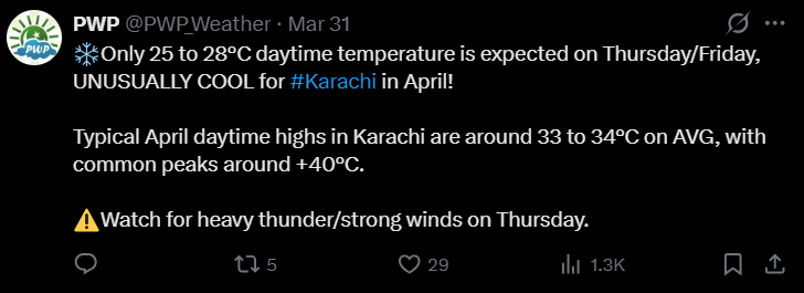
- Record Non-Monsoon Deluge: The instability peaked in early April. On April 2, the Nazimabad (Karachi) recorded an astonishing 97 mm of rainfall within a 24-hour window. This monsoon-like intensity marks the highest official non-monsoon rainfall recorded in recent history. While the Airport Observatory recorded 44 mm, nearly 10 mm short of its historical April record of 52.8 mm set in 1935, the city-wide averages make this the wettest and most coolest April for Karachi since 1985. This has officially been the coolest April since 1985, as night-time temperatures dipped to a low of 16°C.
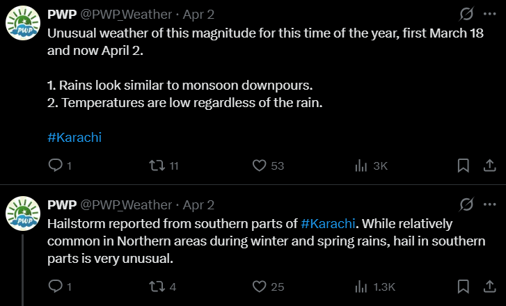
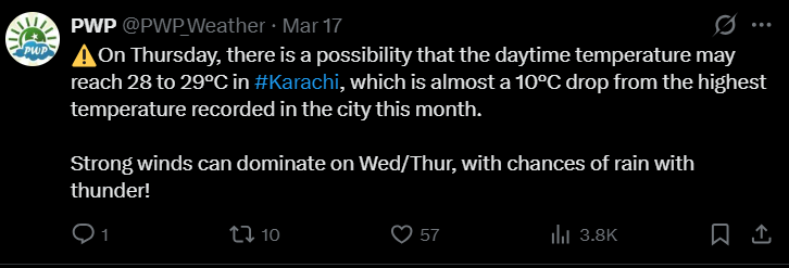
- Thermal Suppression and Hail: The succession of Western Disturbances systematically suppressed the seasonal heatwave. Mid-March saw temperatures plummet by 10°C in a single week, dropping to 28°C–29°C. By early April, daytime highs struggled to surpass 24°C. Most unusually, the southern districts of the city experienced rare hailstorms, a phenomenon typically confined to much higher latitudes.
Public discourse surrounding these anomalies has been varied. There is significant localized chatter suggesting that regional conflicts, specifically the war with Iran, may have inadvertently disrupted the weather modification projects or “evil plans” attributed to international actors. Such theories speculate that Iranian missile strikes on specific centers led to the sudden return of spring rains and snow by neutralizing artificial intervention. However, scientific evidence contradicts these claims; modern numerical weather models predicted this pattern weeks in advance. The precision of these long-range forecasts underscores that these events are the result of natural meteorological shifts, debunking speculations regarding cloud seeding or military-induced weather changes.
Conclusion: Echoes of the 2024 Climate Pattern
The climatic volatility of 2026 is not an isolated anomaly but part of a documented pattern linked to the ENSO cycle, mirroring the historic weather events recorded just two years prior.
Looking at Pakistan
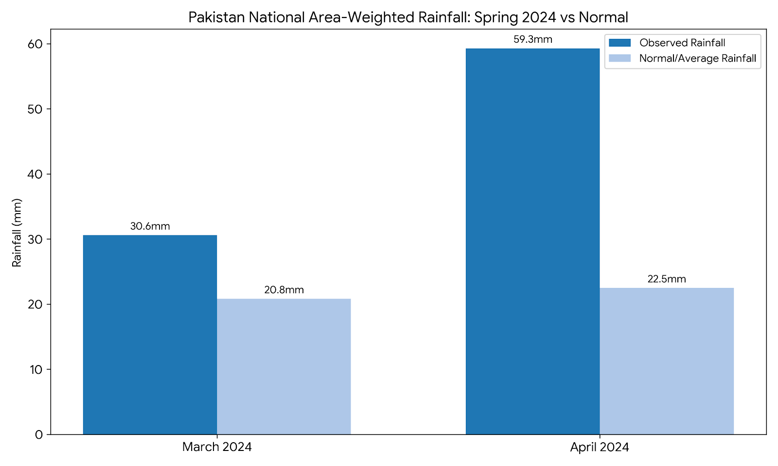
Data from the Pakistan Meteorological Department (PMD) highlights a striking parallel with Spring 2024. During March 2024, the national area-weighted rainfall reached 30.6 mm, which was 47% above average, driven by persistent westerly waves. While the national mean monthly temperature of 18.78°C remained near the country average (a negligible -0.08°C anomaly), the rainfall patterns signaled a major shift. This trend intensified in April 2024, which became Pakistan’s wettest April since 1961. The country received 164% above-average rainfall (59.3 mm compared to the normal 22.5 mm), and national temperatures were 0.87°C cooler than the monthly average. In 2026, the Government of Pakistan stated that the national area-weighted rainfall of 38.9mm was slightly above average, with a positive departure of +24% in March 2026.
Again taking Karachi’s example, the city recorded 75 mm of rain at the Faisal Base in February 2024, representing one of the heaviest February downpours in recent memory and resulting in widespread flooding. This was followed by further heavy rainfall in early March, establishing a pattern that closely aligns with the events unfolding in 2026.
Looking at the Wider Region
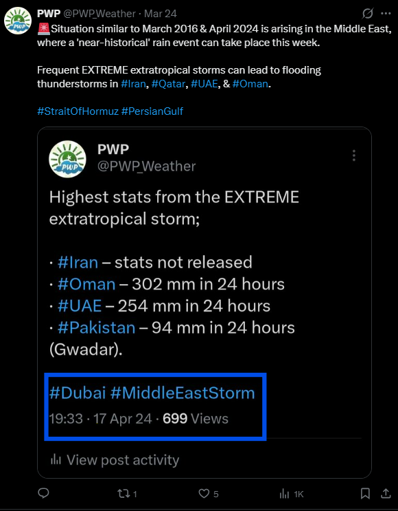
The spring of 2026 has also been marked by widespread and intense rain activity across the Middle East, a pattern that bears an uncanny resemblance to the events of April 2024. During that period, the region experienced historic torrential downpours that led to significant urban flooding, most notably in UAE, Iran and parts of Oman. This recurrence suggests that the current atmospheric setup is mirroring the high-volatility transition phase seen two years ago.
The primary difference between the two periods lies in the phase of the ENSO cycle. The 2024 anomalies were driven by the weakening phase of a strong El Niño, whereas the 2026 events are being driven by a developing El Niño. Despite being on opposite ends of the cycle, both transition periods created an identical atmospheric outcome: the funneling of intense Extratropical Storms into the region, resulting in heavy precipitation, high winds, and suppressed spring temperatures.
