

![]()
This is a part of Monsoon of Pakistan page
Provincial capitals 2013 June rainfall
Highest rain in the month of June was recorded in Murree – 303.1 mm (average monthly rain is 130 mm). The average rainfall is taken from Hong Kong Observatory (HKO);
- Islamabad got 78 mm (average monthly rain is 62.2 mm)
- Karachi got 22 mm (average monthly rain is 3.9 mm )
- Lahore got 177 mm (average monthly rain is 36.3 mm)
- Peshawar got 17.4 mm (average monthly rain is 7.7 mm)
- Muzaffarabad got 91 mm.
- Quetta did not get measurable rain.
Date of Issue – June 30
June ends with significant rains in Khyber and North Punjab
After three days – Rain coverage weakens over KPK, shifts towards Punjab!
First spell would weaken after night!
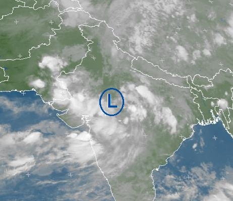
Western trough ’11’ now persists over the northern areas of the country. The Low pressure persist over the same area that is East Utter Pradesh. Thunderstorm has formed over NE Balochistan and adjoining south Punjab another over central Balochistan and adjoining Sindh. During the night, a thunderstorm can affect the northern areas of the country, mostly Punjab and Azad Kashmir including Islamabad.
The first spell of monsoon in the northern areas would weaken after tonight, the spell would continue till July 1 with further weakening. Monsoon rains with thunder/lightning along with fast winds can occur Islamabad, Northern Punjab (Lahore, Rawalpindi, Sialkot, Gujranwala, Gujrat, Jhelum, Faisalabad and adjoining cities), Khyber Pakhtunkhwa (Peshawar, Khyber Agency, Landi Kotal, Orakzai Agency, Abbottabad and adjoining cities) and Azad Kashmir, the rains can last till June 30/July 1 night. During this period, there chances of isolated heavy rainfall with strong winds (>56 km/h) in Abbottabad, Khurram , Khyber, Orakazi Agency, Landi Kotal, Haripur, Manshera, Murree, Muzaffarabad, Rawalpindi, Attock, Lahore, Sialkot and adjoining cities areas. There are chances of isolated rain in Khuzdar, Kalat, Awaram, Zhob, Musa Khel, Barkhan and few adjoining districts of Balochistan during this period. Sindh can witness some clouds during this period especially NW upper parts of Sindh with windy conditions, there are some chances of showers in Tharparkar district while chances of drizzle in Sindh coastal strip including Karachi. South Punjab can too witness clouds with chances of showers in Dera Ghazi Khan and Bahawalnagar district. Following is the amount of rainfall in the country;
- Punjab
- Mianwali got 58 mm.
- Jhang got 50 mm.
- Okara got 38 mm.
- Noorpur Thal got 29 mm.
- Mandibahaudin got 25 mm.
- Faisalabad got 23 mm.
- Joharabad got 22 mm.
- Sahiwal got 21 mm.
- Lahore got 17 mm.
- Sargodha got 17 mm.
- Jhelum got 16 mm.
- Sialkot got 8 mm.
- Bahawalnagar got 4 mm. (South Punjab)
- Gujranwala got 3 mm.
- Khyber Pakhtunkhwa
- Malamjaba got 18 mm.
- Parachinar got 16 mm.
- Kohat got 8 mm.
- D.I Khan got 7 mm.
- Chitral got 2 mm.
Date of Issue – June 29
‘Monsoon rains continue in the north!’
Isolated Heavy rainfall with strong gusty winds in Rawalpindi occurred!
Western trough ’11′ persists over the north-western areas of the country. The Low pressure persist over the same area that is East Utter Pradesh, monsoon is weak over western India while intensity is weak over the western coast of India. Fresh thundercloud is seen forming over central Balochistan while another over north-eastern Balochistan, this thundercloud is merging with a larger thunderstorm over eastern Khyber Pakhtunkhwa. The KPK thunderstorm is moving towards Islamabad, Azad Kashmir and northern Punjab.
Monsoon rains with thunder/lightning along with fast winds can occur Islamabad, Northern Punjab (Lahore, Rawalpindi, Sialkot, Gujranwala, Gujrat, Jhelum, Faisalabad and adjoining cities), Khyber Pakhtunkhwa (Peshawar, Khyber Agency, Landi Kotal, Orakzai Agency, Abbottabad and adjoining cities) and Azad Kashmir, the rains can last till June 30/July 1 night. During this period, there chances of isolated heavy rainfall with strong winds (>56 km/h) in Abbottabad, Khurram , Khyber, Orakazi Agency, Landi Kotal, Haripur, Manshera, Murree, Muzaffarabad, Rawalpindi, Attock, Lahore, Sialkot and adjoining cities areas. There are chances of isolated rain in Khuzdar, Kalat, Awaram, Zhob, Musa Khel, Barkhan and few adjoining districts of Balochistan during this period. Sindh can witness some clouds during this period especially NW upper parts of Sindh, there are some chances of showers in Tharparkar district while chances of drizzle in Sindh coastal strip including Karachi. South Punjab can too witness clouds with chances of showers in Dera Ghazi Khan and Bahawalnagar district. Following is the amount of rainfall in the country;
- Islamabad got 27 mm.
- Punjab
- Rawalpindi got 68 mm.
- Murree got 34 mm.
- Mandi bahauddin got 22 mm.
- Jhelum got 17 mm.
- Sialkot got 8 mm.
- Lahore got 5 mm.
- Khyber Paktunkhwa
- Saidusharif got 55 mm.
- Mallamjabba got 38 mm.
- Kakul got 29 mm.
- Balakot got 23 mm.
- Kalam got 12 mm.
- Dir got 10 mm (Lower Dir got 5 mm).
- Peshawar got traces.
- Azad Kashmir
- Kotli got 7 mm.
- Muzaffarabad got 3 mm.
- Rawalkot got 2 mm.
- Balochistan
- Zhob got 11 mm.
- Barkhan got 3 mm.
Date of Issue – June 28
‘Monsoon rains continue in the North – Likely to persist till two to three days’
Most rain falling in Khyber Pakhtunkhwa
Western trough ’11′ is over the north-western areas of Pakistan, yesterday’s low pressure area over south-east Utter Pradesh is now over east Utter Pradesh, deepening was observed on June 27 night. The low pressure is likely to persist till July 1.
Monsoon rains with thunder/lightning along with fast winds can occur Islamabad, Northern Punjab (Lahore, Rawalpindi, Sialkot, Gujranwala, Gujrat, Jhelum, Faisalabad and adjoining cities), Khyber Pakhtunkhwa (Peshawar, Khyber Agency, Landi Kotal, Orakzai Agency, Abbottabad and adjoining cities) and Azad Kashmir, the rains can last till June 30/July 1 night. During this period, there chances of isolated heavy rainfall with strong winds (>56 km/h) in Abbottabad, Khurram , Khyber, Orakazi Agency, Landi Kotal, Haripur, Manshera, Murree, Muzaffarabad, Rawalpindi, Attock, Lahore, Sialkot and adjoining cities areas. There are chances of isolated rain in Khuzdar, Kalat, Awaram, Zhob, Musa Khel, Barkhan and few adjoining districts of Balochistan during this period. Sindh can witness some clouds during this period especially NW upper parts of Sindh, there are some chances of showers in Tharparkar district while chances of drizzle in Sindh coastal strip including Karachi. South Punjab can too witness clouds with chances of showers in Dera Ghazi Khan and Bahawalnagar district. Following is the amount of rainfall in the country;
- Islamabad got 2 mm.
- Punjab
- Murree got 2 mm.
- Khyber Pakhtunkhwa
- Bannu got 71 mm.
- Balakot got 16 mm.
- D.I Khan got 7 mm.
- Saidu Sharif got 4 mm.
- Rawalpindi got 1 mm.
- Lahore got 1 mm.
- Balochistan
- Barkhan got 20 mm.
- Khuzdar got 1 mm.
- Azad Kashmir
- Muzaffarabad got 15 mm.
- Kotli got 1 mm.
Date of Issue – June 27
Monsoon has hit the Northern areas of the country with scattered rains!
More rain expected in the north
Monsoon has advanced into the northern areas of the country on June 27 – Last week of June (predicted in PWP’s Monsoon V) as scattered activity has been observed there with isolated heavy falls, more thunderstorms have formed over the northern areas, approaching Islamabad. Following is the amount of rainfall recorded till the morning of June 27;
- Islamabad got 18 mm.
- Punjab
- Murree got 65 mm.
- Chakwal got 24 mm.
- Jhelum got 23 mm.
- Gujranwala got 26 mm.
- Mandibahaudin got 18 mm.
- Rawalpindi got 14 mm.
- Sialkot got 8 mm.
- Lahore got 1 mm.
- Bhakkar got 1 mm.
- Azad Kashmir
- Kotli got 53 mm.
- Balakot got 47 mm.
- Mangla got 36 mm.
- Muzaffarabad got 15 mm.
- Khyber Pakhtunkhwa
- Kakul got 64 mm.
- Lower Dir got 32 mm.
- Parachinar got 29 mm.
- Balochistan
- Khuzadar got 13 mm.
- Zhob got 5 mm.
Yesterday’s low pressure area over south-east Utter Pradesh and has interacted with the western trough ’11′ over the north-western areas of Pakistan.
From June 27 night, monsoon rains with thunder/lightning along with fast winds can occur Islamabad, Northern Punjab (Lahore, Rawalpindi, Sialkot, Gujranwala, Gujrat, Jhelum, Faisalabad and adjoining cities), Khyber Pakhtunkhwa (Peshawar, Khyber Agency, Landi Kotal, Orakzai Agency, Abbottabad and adjoining cities) and Azad Kashmir, the rains can last till June 30/July 1 night. During this period, there chances of isolated heavy rainfall with strong winds (>56 km/h) in Abbottabad, Haripur, Manshera, Murree, Muzaffarabad, Rawalpindi, Attock and adjoining cities areas. Sindh can witness some clouds during this period, there are some chances of showers in Tharparkar district while south Punjab can too witness clouds with chances of showers in Dera Ghazi Khan and Bahawalnagar district.
Date of Issue – June 26
‘Isolated Rains have hit the North’
Intensity to increase in coming days
Scattered activity required to declare monsoon – Waiting!
Yesterday’s low pressure area over east central India (North Chhattisgarh and adjoining states) has moved in a WNW direction towards south-east Utter Pradesh since a western trough ’11′ is approaching the north-western areas of Pakistan on June 26 night, the low will have difficulty moving westwards. Monsoon has started advancing into the northern areas of the country though weak in intensity, currents to increase from June 27 night – Last week of June (predicted in Monsoon V).
Tonight chances of rain/showers with fast winds in upper areas of Khyber Pakhtunkhwa and adjoining Azad Kashmir including Islamabad while dusty conditions can occur in lower central Balochistan and central Punjab. From June 27 night, monsoon rains with thunder/lightning along with fast winds can occur Islamabad, Northern Punjab (Lahore, Rawalpindi, Sialkot, Gujranwala, Gujrat, Jhelum, Faisalabad and adjoining cities), Khyber Pakhtunkhwa (Peshawar, Khyber Agency, Landi Kotal, Orakzai Agency, Abbottabad and adjoining cities) and Azad Kashmir, the rains can last till three to four days depending when they hit those areas of the country. During this period, there chances of isolated heavy rainfall with strong winds (>56 km/h) in Abbottabad, Haripur, Manshera, Murree, Muzaffarabad, Rawalpindi, Attock and adjoining cities areas. Sindh can witness some clouds during this period, there are some chances of showers in Tharparkar district while south Punjab can too witness clouds with chances of showers in Dera Ghazi Khan and Bahawalnagar district. Following is the amount of rainfall in the country;
- Punjab
- Sialkot got 7 mm.
- Azad Kashmir
- Muzaffarabad got 9 mm.
- Rawalkot got 9 mm.
- Khyber Pakhtunkhwa
- Saidu Sharif got 53 mm.
- Balakot got 53 mm.
- Lower Dir got 29 mm.
- Parachinar got 3 mm.
Date of Issue – June 25
‘Monsoon rains at the door in the North!’
Dry conditions ended – Rain returns
Low pressure area is over east central India (North Chhattisgarh and adjoining states), it could move in a WNW direction while a western trough ’11′ can reach the north-western areas of Pakistan on June 26 night. Monsoon can start advancing into the northern areas of the country on June 26/June 27 – Last week of June (predicted in Monsoon V). PWP upgrades the possibility of rains in the north to ‘extremely high’ from ‘high’.
Tonight chances of isolated showers with fast winds in upper areas of Khyber Pakhtunkhwa, Azad Kashmir and adjoining areas of Punjab. Monsoon can start advancing into the northern areas of the country on June 26/June 27 due to which rain with thunder/lightning along with fast winds can occur Islamabad, Northern Punjab (Lahore, Rawalpindi, Sialkot, Gujranwala, Gujrat, Jhelum, Faisalabad and adjoining cities), Khyber Pakhtunkhwa (Peshawar, Khyber Agency, Landi Kotal, Orakzai Agency, Abbottabad and adjoining cities) and Azad Kashmir, the rains can last till three to four days depending when they hit those areas of the country. During this period, there chances of isolated heavy rainfall with strong winds (>56 km/h) in Abbottabad, Haripur, Manshera, Murree, Muzaffarabad, Rawalpindi, Attock and adjoining cities areas. Sindh and south Punjab can witness some clouds during this period, there are some chances of showers in Tharparkar and Bahawalnagar district of those provinces. Following is the amount of rainfall in the country;
- Azad Kashmir
- Rawalakot got 13 mm.
- Muzafarabad got 5 mm.
- Kotl got 3 mm.
Date of Issue – June 24
‘Rains approaching North!’
Mostly dry weather to continue in the country till one to two days. Thundercloud dissipated over Jammu & Kashmir, another weak thundercloud dissipated over north-eastern and lower Balochistan.
Monsoon has started reviving due to the formation of low pressure area in the Bay of Bengal, it could move in a WNW direction. now it lies over Odisha and West Bengal. Monsoon could advance into the northern areas of Pakistan during the last week of June (predicted in Monsoon V) that could be June 26 (+1, -1 day error), therefore PWP upgrades the first spell of monsoon from ’high’ in the northern areas. The rains can start last till three to four days depending when they hit the country during this period moderate rain with thunder/lightning expected in Islamabad, Lahore, Gujranwala, Jhelum, Rawalpindi, Sialkot and adjoining areas. Sindh and south Punjab can witness some clouds during this period, there are some chances of showers in Tharparkar and Bahawalnagar district of those provinces.
Date of Issue – June 23
‘Rains approaching North’
Mostly dry weather to continue in the country till two to three days. Two weak thundercloud formed over Jammu & Kashmir, both are moving in a eastern direction. Another formed over central Balochistan while the third formed over north-eastern Balochistan, both have dissipated.
Monsoon has started reviving due to the formation of low pressure area in the Bay of Bengal, it could move in a WNW/NW direction. Currently it lies over coastal Odisha. Monsoon could advance into the northern areas of Pakistan during the last week of June (predicted in Monsoon V) that could be June 26 (+1, -1 day error), therefore PWP forecasts the first spell of monsoon from ’moderate’ to ‘high’ in the northern areas. The rains can start last till three to four days depending when they hit the country during this period moderate rain with thunder/lightning expected in Islamabad, Lahore, Gujranwala, Jhelum, Rawalpindi, Sialkot and adjoining areas. Sindh and south Punjab can witness some clouds during this period.
Date of Issue – June 22
Dry weather to continue in the country till three to four days, temperatures are high in some parts of the country. A very weak thundercloud formed over Jammu & Kashmir, it dissipated. Another formed over central Balochistan and adjoining Sindh, it dissipated as it moved in a western direction.
Monsoon has started reviving due to the formation of low pressure area in the Bay of Bengal, it could move in a WNW/NW direction. Currently it lies over coastal Odisha. Monsoon could advance into the northern areas of Pakistan during the last week of June (predicted in Monsoon V), therefore PWP forecasts the first spell of monsoon from ‘poor’ to ‘moderate’ in the northern areas.
Date of Issue – June 21
Dry weather to continue in the country till four to five days, temperatures are high in some parts of the country. Monsoon is going to revive due to the formation of a low pressure area in the Bay of Bengal in the next 36 to 48 hours as an area of upper air cyclonic circulation lies in east-central Bay of Bengal, it could move in a WNW/NW direction.
Monsoon could advance into the northern areas of Pakistan during the last week of June (predicted in Monsoon V), therefore PWP forecasts the first spell of monsoon to ‘poor’ in the northern areas.
Date of Issue – June 20
Dry weather expected in Pakistan till some days due to the penetration of dry westerlies, temperatures have risen in the some parts of the country. As monsoon weakens over the west coast, heavy rain activity now seen over eastern coast and and north-eastern states of India.
Date of Issue – June 19
Dry weather expected in Pakistan till some days due to the penetration of dry westerlies, temperatures started rising in some parts of the country. Almost whole Pakistan today remained without any major cloud formation however a very weak thundercloud dissipated over north-western Karachi.
Date of Issue – June 18
‘Dry weather to continue’
Upper air cyclonic circulation has formed in the east central Bay of Bengal. Mostly dry weather expected in Pakistan till some days due to the penetration of dry westerlies, temperatures to rise in some parts of the country from tomorrow. Following is the amount of rainfall in the country;
- Punjab
- Sialkot got 13 mm
- Khyber Pakhtunkhwa
- Malamjabba got 6 mm.
- Balakot got 1 mm.
- Gilgit-Baltistan
- Astore got 6 mm.
- Azad Kashmir
- Muzaffarabad got 2 mm.
In Monsoon V published on June 7, PWP mentioned that monsoon could hit the country especially the northern areas during last weeks of June/first week of July.
Date of Issue – June 17
Weak western trough ’10′ is over the north-eastern areas of the country and adjoining Jammu & Kashmir, it is would completely move eastwards on June 18 mid-day, it has dragged the low pressure over North-east Rajasthan in a NNE direction and it has started weakening and lies over the same area as an upper air cyclonic circulation.
Mostly dry weather is expected in Punjab including Islamabad and Khyber Pakhtunkhwa as the pre-monsoon activity that started from June 11, weakened significantly on June 15 night though it will end on June 17. On June 17 night, north-eastern areas of Punjab can experience isolated rain with thunder/lightning. From June 18, mostly dry weather is expected till many days. Western winds can dominate Khyber Pakhtunkhwa with chances of drizzle/isolated shower in extreme northern Khyber Pakhtunkhwa and Gilgit-Baltistan. Temperatures are going to be calm till the middle of this week and after that a increase would start taking place.
On June 17, coastal, SE and few adjoining central Sindh remained under a cloud-cover. There are chances of pre-monsoon drizzle or light rain in the province (especially Badin, Umerkot, Thatta, Karachi, Hyderabad, Sanghar, Khairpur, Sukkur and adjoining areas)till June 18, PWP maintains the chance at ‘moderate’. From June 18 mid-day dry weather could prevail over Sindh. Following is the amount of rainfall in the country;
- Punjab
- Murree got 23 mm.
- Sialkot got 18 mm.
- Jhelum got 2 mm.
- South Punjab
- Bahawalpur got 12 mm.
- Khyber Pakhtunkhwa
- Peshawar got 14 mm.
- Parachinar got 5 mm.
- Azad Kashmir
- Rawalkot got 41 mm.
- Muzaffarabad got 4 mm.
- Sindh
- Mithi got 1 mm.
Date of Issue – June 16
Weak western trough ’10′ is over the northern areas of the country and adjoining Jammu & Kashmir, it is moving eastwards, it has slightly dragged the low pressure over West Madya Pradesh and adjoining Rajasthan in a NNE direction and it has started weakening.
Mostly dry weather is expected in Punjab including Islamabad and Khyber Pakhtunkhwa as the pre-monsoon activity that started from June 11, weakened significantly on June 15 night though it will end on June 17. On June 16/June 17, north-eastern areas of Punjab can experience isolated rain with thunder/lightning. From June 18, mostly dry weather is expected till many days. Western winds can dominate Khyber Pakhtunkhwa. Temperatures are going to be calm till the middle of this week and after that a increase would start taking place. There are chances of drizzle/isolated showers in South Punjab tonight.
There are chances of another pre-monsoon activity in Sindh (not significant), it is weak when compared to the last pre-monsoon activity. PWP upgrades the chance of this spell to ‘moderate’ as weak moisture incursion is taking place in eastern Sindh. This spell has only potential to cause drizzle or light rain in the province (especially Badin, Umerkot, Thatta, Karachi, Hyderabad, Sanghar, Khairpur, Sukkur and adjoining areas) on June 16 till June 18. Some districts like Tharparker, Badin and Thatta can experience isolated moderate rain with thunder/lightning on June 16 night/June 17 morning. Following is the amount of rainfall in the country;
- Punjab
- Bhakkar got 23 mm.
- Murree got 7 mm.
- South Punjab
- Multan got 13 mm.
- Khyber Pakhtunkhwa
- Malamjabba got 30 mm.
- Bannu got 21 mm.
- Lower Dir got 16 mm.
- Azad Kashmir
- Rawalkot got 11 mm.
- Muzaffarabad got 10 mm.
- Sindh
- Jacobabad got 52 mm.
- Rohri got 29 mm.
- Sukkur got 28 mm.
Date of Issue – June 15
‘Very heavy rainfall in Lahore as 102 mm rain recorded’
Another spell in Sindh at ‘poor’
14 dead in late night storm in the North
Low pressure over India
Weak western trough ’10′ is over the northern areas of the country and adjoining Jammu & Kashmir. Yesterday’s low pressure over Chhattisgarh is now over West Madya Pradesh and adjoining Rajasthan.
The current pre-monsoon spell in the northern and central areas of the country has weakened significantly, it will continue in the northern areas till June 17 morning while in central areas till June 16. On June 16/June 17, chances of rain with thunder/lightning in the northern and north-eastern areas of the country including Islamabad and Azad Kashmir. North-eastern areas of Punjab (Lahore, Gujranwala, Jhelum, Sialkot and other adjoining cities can experience rain on June 16/June 17). South Punjab (Multan, Bahawalpur, Bahawalnagar and adjoining cities) can experience rain/showers on June 15 night/June 16. Chances of isolated rain/showers in Khyber Pakhtunkhwa including Peshawar till June 16/June 17 morning. North-eastern and lower central areas of Balochistan can experience isolated rain till June 17/June 18. From June 18, there is a possibility of long dry conditions in the northern and central areas.
Moisture incursion from the low over central India can cause another pre-monsoon spell in some parts of Sindh (especially Badin, Umerkot, Thatta, Karachi, Hyderabad, Sanghar, Khairpur and adjoining upper areas) on June 16 till June 18 morning, there are chances of drizzle/light rain therefore PWP upgrades this spell from ‘very poor’ to ‘poor’at the moment. Some parts of eastern and western Sindh saw thunderclouds on June 15 due to the moisture incursion. As predicted by PWP since June 9, widespread pre-monsoon rainfall occurred in the country with very heavy rainfall in NE Punjab especially Lahore. Following is the amount of rainfall in the country;
- Islamabad got 18 mm.
- Punjab
- Lahore got 102 mm. (Lahore’s monthly average is 36 mm)
- T.T Singh got 49 mm.
- Mianwali got 43 mm.
- Jhelum got 39 mm.
- Murree got 38 mm.
- Jhang got 30 mm.
- Sialkot got 21 mm.
- Faisalabad got 15 mm.
- Rawalpindi got 14 mm.
- South Punjab
- Bahawalnagar got 18 mm.
- Khyber Pakhtunkhwa
- Bannu got 09 mm.
- Azad Kashmir
- Rawalkot got 42 mm.
- Sindh
- Badin got 9 mm.
Monsoon could hit the country especially the northern areas during last weeks of June or first week of July which could be early than last years.
Date of Issue – June 14
Very heavy rainfall cannot be ruled out in NE Punjab!
Weak western trough ’10′ is over the northern areas of the country. Upper air cyclonic circulations is now over north-western Rajasthan and adjoining Punjab, it has weakened. Well-marked low pressure over central eastern India over the state of southern Odisha has weakened into a low pressure and lies over Chhattisgarh. Monsoon is advancing into western states of India with an unusual fast speed, itset over eastern Rajasthan on June 13, could hit New Delhi on June 18.
The current pre-monsoon spell in the northern and central areas of the country is the last pre-monsoon spell of the season that is expected to last till June 16/June 17. From June 13, rain can be at times heavy with thunder/lightning especially in the northern and north-eastern areas of the country including Islamabad and Azad Kashmir. North-eastern areas of Punjab (Lahore, Gujranwala, Jhelum, Sialkot and other adjoining cities can experience heavy rainfall to very heavy rainfall between June 13/June 15). South Punjab (Multan, Bahawalpur, Bahawalnagar and adjoining cities) can experience rainfalls during this period with thunder/lightning. Rain can occur in Khyber Pakhtunkhwa as well including Peshawar due to the interaction with western winds from June 13/June 14, south Khyber Pakhtunkhwa and adjoining Balochistan can experience isolated heavy rainfall. In the northern and central, this first pre-monsoon spell might end on June 15 night or June 17 morning.
Slight chances of isolated showers in the eastern parts (Badin, Umerkot, Thatta, Sanghar, Khairpur and adjoining areas). Another pre-monsoon spell (last pre-monsoon spell) can hit Sindh on June 16 night/June 17 due to the Bay’s low pressure therefore PWP maintains this spell at ‘very poor’ at the moment. Following is the amount of rainfall in the country;
- Punjab
- Bhakker got 60 mm.
- Mianwali got 20 mm.
- Jorabad got 14 mm.
- Murree got 11 mm.
- Rawalpindi got 10 mm.
- South Punjab
- Bahawalnagar got 16 mm.
- Khyber Pakhtunkhwa
- D.I Khan got 72 mm.
- Bannu got 26 mm.
- Azad Kashmir
- Rawalkot got 37 mm.
- Muzaffarabad got 24 mm.
- Balochistan
- Pasni got 21 mm.
- Zhob got 20 mm.
Monsoon could hit the country especially the northern areas during last weeks of June or first week of July which could be early than last years.
Date of Issue – June 13
Pre-monsoon hits Karachi!
West – East Interaction – Very heavy rainfall possible in North!
Another monsoon spell can approach Sindh
Weak western trough ’10′ is over the north-western areas of the country. Upper air cyclonic circulations from the north Arabian sea now persists over Sindh and adjoining Gujarat, it has weakened. Well-marked low pressure from the Bay of Bengal is over central eastern India over the state of southern Odisha. Monsoon is advancing into western states of India with an unusual fast speed, it has set over eastern Rajasthan, could hit New Delhi on June 18 (10 days ahead).
The current pre-monsoon spell in the northern and central areas of the country is the last pre-monsoon spell of the season that is expected to last till June 16/June 17. From June 13, rain can be at times heavy with thunder/lightning especially in the northern and north-eastern areas of the country including Islamabad and Azad Kashmir. North-eastern areas of Punjab (Lahore, Gujranwala, Jhelum, Sialkot and other adjoining cities can experience heavy rainfall to very heavy rainfall between June 13/June 15). South Punjab (Multan, Bahawalpur, Bahawalnagar and adjoining cities) can experience rainfalls during this period with thunder/lightning. Rain can occur in Khyber Pakhtunkhwa as well including Peshawar due to the interaction with western winds from June 13/June 14, south Khyber Pakhtunkhwa and adjoining Balochistan can experience isolated heavy rainfall. In the northern and central, this first pre-monsoon spell might end on June 15 night or June 17 morning.
Slight chances of isolated showers in the eastern parts (Badin, Umerkot, Thatta, Sanghar, Khairpur and adjoining areas). Another pre-monsoon spell (last pre-monsoon spell) can hit Sindh on June 16 night/June 17 due to the Bay’s low pressure therefore PWP maintains this spell at ‘very poor’ at the moment. Following is the amount of rainfall in the country;
- South Punjab
- Bahawalpur got 16 mm.
- Multan got 13 mm.
- Sindh
- Chhor got 47 mm.
- Padidan got 26 mm.
- Mithi and Moen-jo-Daro got 24 mm.
- Karachi got 22 mm (Gulshan-e-Hadeed)
- Nawabshah got 16 mm.
- Azad Kashmir
- Abbotabad got 38 mm.
- Muzaffarabad got 4 mm.
- Balochistan
- Kalat got 4 mm.
- Lasbella got 4 mm.
Monsoon could hit the country especially the northern areas during last weeks of June or first week of July which could be early than last years.
Date of Issue – June 12
‘Pre-monsoon has hit whole country from North to South’
Sindh and Balochistan got rain today!
More rain expected!
Weak Western trough ’10′ have approached the northern areas of the country which could cause interaction between eastern and western winds. Low pressure from the Bay of Bengal is now over Odisha and adjoining Andhra Pradesh, upper air cyclonic circulations over Guajrat and adjoining Sindh. Coastal thunderstorm is moving away into the Arabian sea now. Dissipating thunderclouds over Sindh and adjoining Balochistan and south Punjab. High and mid level clouds over the northern areas. Strong thunderstorm over Makran coast.
On June 13, rain can be at times heavy with thunder/lightning especially in the northern and north-eastern areas of the country including Islamabad and Azad Kashmir. North-eastern areas of Punjab (Lahore, Gujranwala, Jhelum, Sialkot and other adjoining cities can experience heavy rainfall to very heavy rainfall between June 13/June 15). South Punjab (Multan, Bahawalpur, Bahawalnagar and adjoining cities) can experience rainfalls during this period with thunder/lightning. Rain can occur in Khyber Pakhtunkhwa as well including Peshawar due to the interaction with western winds from June 13/June 14, south Khyber Pakhtunkhwa and adjoining Balochistan can experience isolated heavy rainfall. In the northern and central, this first pre-monsoon spell might end on June 15 night or June 17 morning. In Sindh province including Karachi, Hyderabad, Thatta, Mirpur Khas, Badin, Nawabshah, Sukkur, Larkana, Tharparkar and adjoining cities, on June 13 till June 14 night there are chances of rain at time moderate (heavy in the south-eastern parts of Sindh), from June 16 there are chances of new pre-monsoon spell in Sindh, PWP forecast them at the moment at ‘extremely poor’. Following are the rainfall recorded today;
- Islamabad got 13 mm.
- Punjab
- Murree got 74 mm.
- Joharabad got 70 mm.
- Faisalabad got 60 mm.
- Lahore got 51 mm.
- Chawal got 38 mm.
- Gujranwala got 32 mm.
- Rawalpindi got 15 mm.
- South Punjab
- Bahawalpur got 47 mm.
- Multan got 21 mm.
- Khyber Pakhtunkhwa
- Abbottabad got 23 mm.
- Parachinar got 21 mm.
- D.I Khan got 6 mm.
- Sindh
- Padidan got 60 mm.
- Dadu got 14 mm.
- Badin got 4 mm.
- Karachi got T.R
- Azad Kashmir
- Kotli got 36 mm.
- Muzaffarabad got 5 mm.
- Balochistan
- Bharkhan got 6 mm.
In the month of June two spells of rain can occur, one which is currently active and the other during the last weeks of June. Pre-monsoon hit Sindh on June 4, North Punjab, Khyber Pakhtunkhwa and Azad Kashmir on June 11, south Punjab on June 12.
Date of Issue – June 11
Very heavy rainfall can occur in NE Punjab!
Pre-monsoon hits NE Punjab with dust storms and rain – 4 dead
‘Scattered to widespread Pre-Monsoon rain can occur in Pakistan in June’
Scattered to widespread pre-monsoon rain can occur in many parts of the country during this week around June 14 (+2, -2 day error) that will continue till three to four days, northern areas can get rains till early next week. From June 12/June 13 rain can occur in Punjab (North and South) and Sindh. Rain can be at times heavy with thunder/lightning especially in the northern and north-eastern areas of the country including Islamabad and Azad Kashmir. North-eastern areas of Punjab (Lahore, Gujranwala, Jhelum, Sialkot and other adjoining cities can experience heavy rainfall to very heavy rainfall between June 13/June 15). South Punjab (Multan, Bahawalpur, Bahawalnagar and adjoining cities) can experience rainfalls during this period with thunder/lightning. Rain can occur in Khyber Pakhtunkhwa as well including Peshawar due to the interaction with western winds from June 13/June 14, south Khyber Pakhtunkhwa and adjoining Balochistan can experience isolated heavy rainfall. In Sindh province including Karachi, Hyderabad, Thatta, Mirpur Khas, Badin, Nawabshah, Sukkur, Larkana, Tharparkar and adjoining cities, during this period there are chances of rain at time moderate (heavy in the south-eastern parts of Sindh), around June 13/June 14 and chances will remain till two till three days. Rain at times heavy occurred in Punjab including Islamabad and Azad Kashmir while showers occurred in Balochistan. Drizzle with thunder/lightning occurred in eastern south Punjab. Dust storm with rain has killed four people in Lahore. Following are the rainfall recorded today;
- Punjab
- Murree got 41 mm
- Balochistan
- Kalat got 8 mm
Upper air cyclonic circulation over north-eastern Arabian has moved into Gujarat and adjoining Sindh, another lies over Bay of Bengal, it could intensify into a low pressure in 24 to 36 hours. In the month of June two spells of rain can occur, one during the coming week and the other during the last weeks of June. PWP maintains the chance of first pre-monsoon spell at ‘extremely high’ in the north, central and southern areas of the country.
Date of Issue – June 10
Very heavy rainfall can occur in NE Punjab in two to three days!
‘Scattered to widespread Pre-Monsoon rain can occur in Pakistan in June’
Drainage system should be cleaned immediately!
Scattered to widespread pre-monsoon rain can occur in many parts of the country during this week around June 14 (+2, -2 day error) that will continue till three to four days, northern areas can get rains till early next week. From June 12/June 13 rain can occur in Punjab (North and South) and Sindh. Rain can be at times heavy with thunder/lightning especially in the northern and north-eastern areas of the country including Islamabad and Azad Kashmir. North-eastern areas of Punjab (Lahore, Gujranwala, Jhelum, Sialkot and other adjoining cities can experience heavy rainfall to very heavy rainfall between June 13/June 15). South Punjab (Multan, Bahawalpur, Bahawalnagar and adjoining cities) can experience rainfalls during this period with thunder/lightning. Rain can occur in Khyber Pakhtunkhwa as well including Peshawar due to the interaction with western winds from June 13/June 14, south Khyber Pakhtunkhwa and adjoining Balochistan can experience isolated heavy rainfall. In Sindh province including Karachi, Hyderabad, Thatta, Mirpur Khas, Badin, Nawabshah, Sukkur, Larkana, Tharparkar and adjoining cities, during this period there are chances of rain at time moderate (heavy in the south-eastern parts of Sindh), around June 13/June 14 and chances will remain till two till three days.
In the month of June two spells of rain can occur, one during the coming week and the other during the last weeks of June. PWP maintains the chance of first pre-monsoon spell at ‘extremely high’ in the north, upgrades from ‘high’ to ‘very high’ to ‘extremely high’ in the central and southern areas of the country.
Date of Issue – June 9
Very heavy rainfall can occur in NE Punjab this week!
‘Scattered to widespread Pre-Monsoon rain can occur in Pakistan in June’
Drainage system should be cleaned immediately!
Scattered to widespread pre-Monsoon rain can occur in Punjab (North and South) including Lahore and Islamabad during the coming week around June 14 (+2, -2 day error) till three to four days. Rain can be at times heavy with thunder/lightning especially in the northern and north-eastern areas of the country. North-eastern areas of Punjab (Lahore, Gujranwala, Jhelum, Sialkot and other adjoining cities can experienced heavy rainfall to very heavy rainfall between June 13/June 15). During this period rain can occur in Khyber Pakhtunkhwa as well including Peshawar due to the interaction with western winds.In Sindh province including Karachi, during this period there are chances of rain at time moderate (heavy in the south-eastern parts of Sindh), around June 14 (+2, -2 day error) till three to four days depending when they hit.
In the month of June two spells of rain can occur, one during the coming week and the other during the last weeks of June. PWP upgrades the chance of first pre-monsoon spell from ‘high’ to ‘very high’ to ‘extremely high’ in the north, from ‘moderate’ to ‘high’ and maintaining that in central and southern areas of the country. Monsoon has further advanced into the western coast of India including Mumbai.
Date of Issue – June 8
‘Scattered to widespread Pre-Monsoon rain can occur in Pakistan in June’
Drainage system should be cleaned immediately!
Scattered to widespread pre-Monsoon rain can occur in Punjab (North and South) including Lahore and Islamabad during the coming week around June 14 (+2, -2 day error) till three to four days. Rain can be at times heavy with thunder/lightning especially in the northern and north-eastern areas, during this period rain can occur in Khyber Pakhtunkhwa as well including Peshawar due to the interaction with western winds. In Sindh province including Karachi, during this period there are chances of rain at time moderate (heavy in the south-eastern parts of Sindh). In the month of June two spells of rain can occur, one during the coming week and the other during the last weeks of June.
PWP had mentioned on June 4 the upcoming scattered to widespread pre-monsoon rainfall in the month of June. In Monsoon II article published on May 6, PWP mentioned the upcoming chances of pre-monsoon activity in Sindh and some parts of Punjab. In Monsoon V published on June 7, PWP mentioned that monsoon could hit the country especially the northern areas during last weeks of June/first week of July. PWP upgrades the chance of rain spell to ‘high’ in the north, ‘moderate’ in central and southern areas of the country. Monsoon might have hit Mumbai.
Date of Issue – June 7
‘Monsoon makes big gain!’
Monsoon hitting Indian city of Mumbai in 12 to 24 hours. There is a circulation off the coast of western India that is dragging moisture into the Arabian sea and western coast of India. Some high and mid-level clouds have entered Sindh from Gujarat. Chances of pre-monsoon drizzle/isolated showers with lightning eastern coastal Sindh and adjoining SE Sindh.
From June 9, the monsoon coverage in the sub-continent would increase significantly. Two low pressure from the Bay of Bengal can move towards central India, another circulation can form in the North Arabian sea. Monsoon will be very active in the month of June, moderate to heavy downpour can occur in Sindh (including Karachi) and Punjab (including Lahore) during the late midweek and last week of June, eastern & western winds interaction possible during periods of June in upper areas of Pakistan.
Date of Issue – June 6
‘Scattered to widespread Pre-Monsoon rain can occur in Pakistan in June’
Drainage system should be cleaned immediately!
Upper air cyclonic circulations are over Bay of Bengal, it could move towards central India in coming days. A pre-monsoon thunderstorm is just east of Punjab over Indian Punjab, Haryana and Himachal Pradesh, western winds are intensifying it, some clouds can form over North-eastern Punjab. Another over Gujarat, its high and mid-level clouds can reach SE Sindh and coastal Sindh during the night. Tomorrow evening, chances of pre-monsoon drizzle with lightning in SE districts of Sindh.
From June 9, the monsoon coverage in the sub-continent would increase significantly. Two low pressure from the Bay of Bengal can move towards central India, another circulation can form in the North Arabian sea. Monsoon will be very active in the month of June, moderate to heavy downpour can occur in Sindh (including Karachi) and Punjab (including Lahore) during the late midweek and last week of June, eastern & western winds interaction possible during periods of June in upper areas of Pakistan.
Date of Issue – June 5
Low pressure hampers monsoon progress – Quick Recovery expected!
Low pressure off the coast of Oman, has moved inland and moved towards UAE and adjoining Saudi Arabia. It has weakened and it could dissipate in 24 to 36 hours. The Low has weakened the monsoon winds prevailing over western coast of India. No thundercloud formed near eastern Sindh today. Due to the low, a weak thundercloud formed over central Balochistan that later moved towards itself. Tomorrow and day after tomorrow the situation can improve.
From June 9, the monsoon coverage in the sub-continent would increase significantly. Two low pressure from the Bay of Bengal can move towards central India, another circulation can form in the North Arabian sea. Monsoon will be very active in the month of June, heavy downpour can occur in Sindh including Karachi while moderate to heavy downpour can occur in Punjab including Lahore during the late midweek and last week of June, eastern & western winds interaction possible during periods of June in upper areas of Pakistan.
Date of Issue – June 4
‘First Pre-monsoon shower occurred in Pakistan – SE Sindh’
‘Scattered to widespread Pre-Monsoon rain can occur in Pakistan in June’
Drainage system should be cleaned immediately!

Many parts of Sindh witnessed clouds from India
From June 9, the monsoon coverage in the sub-continent would increase significantly. Two low pressure from the Bay of Bengal can move towards central India, another circulation can form in the North Arabian sea. Monsoon will be very active in the month of June, heavy downpour can occur in Sindh including Karachi while moderate to heavy downpour can occur in Punjab including Lahore during the late midweek and last week of June, eastern & western winds interaction possible during periods of June in upper areas of Pakistan.
Western trough ’09′ affecting the northern areas and few adjoining central areas of the country has moved away. There is a low pressure off the coast of Oman, thunderstorms are forming over Gujarat and adjoining Rajasthan, during the next 24 hours chances of pre-monsoon drizzle/showers in SE Sindh, some more eastern clouds can reach Sindh coast including Karachi during the night. Today some light pre-monsoon showers did occur in the eastern part of the province.
Date of Issue – June 3
‘First Eastern clouds of 2013 visible from Sindh’

Picture by Abdul Jabbar – First Eastern Clouds visible from Sindh
Weak western trough ’09′ is still passing through the northern areas of the country, chances of drizzle/isolated showers with dust storm there including Islamabad till 12 hours.
Eastern winds are moving into southern parts of Pakistan; High and mid-level clouds were visible in south-eastern Sindh that were coming from Indian state of Gujarat, during the mid-day a thunderstorm formed over coastal Gujarat. During the coming weeks this activity would increase and bulk of clouds can move into Sindh. First good pre-monsoon activity expected during the late mid week of June in Sindh and Punjab.
Date of Issue – June 2
Weak western trough ’09′ is passing through the northern areas of the country, chances of drizzle/isolated showers with dust storm there including Islamabad. The northern and adjoining central parts of the country are still under the influence of western windshowever the southern and adjoining central parts have disturbed winds. High level clouds from India can be visible in south-eastern Sindh in coming days while weak clouds that are forming over southern parts are moving from S to N/NW direction.
Date of Issue – June 1
Upper air cyclonic circulation are over Chhattisgarh, it is likely to weaken but has caused heatwave to break over central India. Monsoon has advanced into the Indian state of Kerala. There are chances of pre-monsoon activity in Sindh and Punjab in the month of June mainly during the middle of June.
