![]()
-
Negative Indian ocean Dipole declared!
-
Lahore getting frequent rains
-
Karachi waiting for it’s turn
New Update issued Below from July 20 till July 31
Pakistan has turned into Monsoonistan as rains have moved into Pakistan, the only area of the country that continue to get proper rains is the northern areas that since the pre-monsoon activity in June is witnessing healthy amounts of rain while the central and southern areas continue to witness isolated events of rains however during the mid-week of July, some improvement was seen over the country, isolated rains occurred in Sindh and south Punjab while northern areas continued to witness almost daily thundershowers since July 6 though the activity weakened after July 10 before weakening strength on July 15 after a brief gap another monsoon spell is expected in the country.
Factors – Present Conditions
*Western trough ’13′ is over the northern areas of the country.aaa
*Low pressure over West Bengal, Odisha and adjoining Bay of Bengal persists.
*Upper air cyclonic circulation over Haryana and adjoining states of India.
Emerging Factors – Effect on Monsoon

*INDIAN OCEAN DIPOLE – U.S Weather Agency since July 10 has declared Negative Indian Ocean dipole in the Indian Ocean while Madden-Julian Oscillation phase is also observed over Bay of Bengal and Arabian sea that can remain even during the third/fourth spell in the country. The sea surface temperature of Pacific ocean shows a slight cooling near the coast of South America which indicates towards weak La-Nina. In June, International weather Agencies hinted the possibility of formation of La-Nina later in the season.
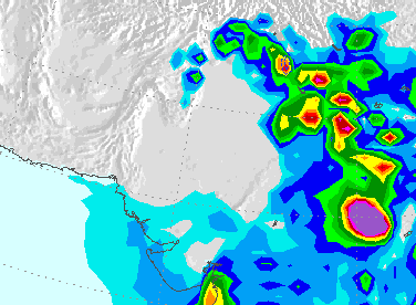
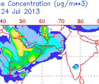
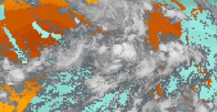
*DUST CLOUD – Strong dust cloud presence over southern, moderate over central while weak over the extreme northern areas. There is no dust cloud cover over the northern areas as per today’s image.
Third Monsoon spell
On July 9, PWP mentioned the chances of third monsoon spell in the northern during the mid-week of July at ‘moderate’ and in coming days it was upgraded to ‘extremely high’, PWP also mentioned chances of monsoon activity in Sindh and south Punjab during the mid-week of July. On July 11, a date of July 15 (+1,-1 day error) was given for third spell in the northern areas. On July 12 night till July 14/July 15, weak monsoon activity was observed in Sindh and south Punjab, following are the total rain recorded for Sindh and South Punjab during that period;
- Mithi got 38 mm.
- Bahawalpur got 25 mm – South Punjab
- Chhor got 10 mm.
- Badin got 14 mm.
- Padidan got 14 mm.
- Thatta got 5 mm.
- Nawabshah got 8 mm.
- Karachi 2.1 mm
- Hyderabad got 1.7 mm
Since the third spell has just started in the northern areas therefore the highest rain recorded during the third spell (July 15 till July 17/July 18) will be given after the spell ends.
North – Rain, rain and rain

This spell which started from July 15 can continue till July 17/July 18. During that period, chances of rain with thunder/lightning in Islamabad, north-eastern Punjab (Lahore, Rawalpindi, Murree city, Jhelum, Gujrat, Faisalabad, Sialkot, Norwal, Sheikpura, Gujranwala, Attock, Mandi Bahauddin and few adjoining districts), Khyber Pakhtunkhwa (Abbottabad, Manshera, Haripur, Swabi, Swat, Peshawar, Landi Kotal, Hangu, Kohat, Khyber Agency, Khurram Agency and few adjoining districts) and Azad Kashmir (Muzaffarabad, Kotli, Mirpur and few adjoining areas with chances of isolated heavy falls).
The third spell which will continue till July 17/July 18 is weaker and isolated when compared to the second spell.
Central Areas – Missed thunderclouds!
South Punjab despite witnessing almost daily weak thundercloud formation near it, has not reported any traces. Partly/mostly cloudy with chances of drizzle/isolated shower in South Punjab (Bahawalpur, Bahawalnagar, Rahim Yar Khan, Vehari, Dera Ghazi Khan and adjoining areas).
Due to the advancement of western trough ’13’, north-eastern parts of Balochistan and adjoining south Punjab has witnessed daily formation of thundercloud since July 15, partly/mostly cloudy with chances of Zhob, Musa Khel, Bharkhan, Dera Bugti, Qila Saifullah, Loralai and few adjoining districts of Balochistan.
South – Under cloud cover
Chances of drizzle/isolated shower in parts of Sindh (Karachi, Thatta, Tharparkar, Mirpur Khas, Umerkot, Badin and adjoining areas) while passing clouds (increase during night/morning) in Sanghar, Khairpur, Sukkur, Gotki and adjoining areas,
Chances of showers in parts of Balochistan (Khuzdar, Awaran, Panjgur, Lasbella, and few adjoining districts), thundercloud activity for past days has been observed over these areas as well.
Fourth Monsoon spell

In PWP’s monsoon update of July 13, it was mentioned that fourth monsoon spell can start after the third spell, the fourth spell has a better coverage. On July 16, PWP gave a date for the fourth monsoon spell in the northern that is July 20 (+1,-1 day error).
During the fourth spell, northern Punjab, Azad Kashmir and parts of Khyber Pakhtunkhwa can witness heavy rain with chances of isolated very heavy rain in northern Punjab and adjoining Azad Kashmir while coastal areas & adjoining south-eastern parts of Sindh and North-eastern Balochistan & parts of south Punjab can witness light showers as per some models, no chances of proper rains yet in Sindh and south Punjab.
- Pakistan Weather Update will be updated once the third monsoon spell ends
Pakistan Weather Update & Monsoon Alert (July 20 – July 31)
-
Fourth Spell is bringing heavy rains to North
-
Fifth Monsoon spell seen for North
-
Wet week ahead!
Pakistan especially the northern areas are under the grip of monsoon rains after the end of third monsoon spell on July 18, the northern areas saw the strongest monsoon spell (fourth spell) of the season from July 20.
Factors – Present Conditions
*Western system ’14’ over the northern areas of Pakistan.
*Upper air cyclonic circulation over Indian Punjab another over north-east Madya Pradesh and adjoining north Chhatisgarh and south-east Utter Pradesh.
*Low pressure over north-western sector of Bay of Bengal.
Recap of the Third Monsoon spell
On July 9, PWP mentioned the chances of third monsoon spell in the northern during the mid-week of July at ‘moderate’ and in coming days it was upgraded to ‘extremely high’, PWP also mentioned chances of monsoon activity in Sindh and south Punjab during the mid-week of July. On July 11, a date of July 15 (+1,-1 day error) was given for third spell in the northern areas. On July 12 night till July 14/July 15, weak monsoon activity was observed in Sindh and south Punjab, following are the total rain recorded for Sindh and South Punjab during that period;
- Mithi got 38 mm.
- Bahawalpur got 25 mm – South Punjab
- Chhor got 10 mm.
- Badin got 14 mm.
- Padidan got 14 mm.
- Thatta got 5 mm.
- Nawabshah got 8 mm.
- Karachi 2.1 mm
- Hyderabad got 1.7 mm
The highest rain (above 40 mm) recorded in the northern areas during the third spell (July 15 till July 17/July 18) is as follow;
- Risalpur got 101 mm – Khyber Pakhtunkhwa
- Lahore got 55 mm (Mirsi Shah Reading) – Punjab
- Islamabad got 46 mm.
- Parachinar got 46 mm – Khyber Pakhtunkhwa
- Jehlum got 43 mm – Punjab
- Kakul got 45 mm – Khyber Pakhtunkhwa
- Mianwali got 43 mm -Punjab
- Dir got 40 mm – Khyber Pakhtunkhwa
The third monsoon spell started from July 15 and ended on July 18. Weak western trough ’13’ was also present during that period. After 24 hours, fourth monsoon spell hit the northern areas, it was also facilitated due to a western system – western disturbance ’14’.
Fourth Monsoon Spell
On July 13, PWP talked about the fourth monsoon spell right after the third spell, in the following days the chances of the fourth spell was upgraded in the northern areas. On July 16, PWP gave a date for the fourth monsoon spell that was July 20 (+1,-1 day error) and told that the spell has the potential to cause isolated very heavy downpour in parts of northern Punjab, Azad Kashmir and Khyber Pakhtunkhwa.
The spell started on July 20 with scattered heavy downpour along with isolated very heavy falls, following is the rain recorded (above 40) on the first day of the spell;
- Islamabad got 217 mm.
- Gujranwala got 130 mm – Punjab
- Sialkot got 111 mm – Punjab
- Rawalakot got 61 mm – Azad Kashmir
- Gujrat got 59 mm – Punjab
Northern Areas – Fourth Monsoon is significant!

“Alert: Scattered heavy rain likely in northern areas of Punjab, some parts of Azad Kashmir and few parts of Khyber Pakhtunkhwa”
Rain at times heavy and thunder/lightning in Islamabad, northern Punjab (Lahore, Rawalpindi, Murree city, Jhelum, Gujrat, Faisalabad, Sialkot, Norwal, Sheikpura, Gujranwala, Attock, Mandi Bahauddin and few adjoining districts), Khyber Pakhtunkhwa (Abbottabad, Manshera, Haripur, Swabi, Swat, Peshawar, Landi Kotal, Hangu, Kohat, Khyber Agency, Khurram Agency and few adjoining districts) and Azad Kashmir (Muzaffarabad, Kotli, Mirpur and few adjoining areas). There are chances of isolated very heavy rainfall in northern areas of Punjab and few parts of Khyber Pakhtunkhwa (Kurram Agency, Khyber Agency, Orakazi Agency, Kohat and adjoining districts) and some parts of Azad Kashmir (Rawalakot, Mirpur, Kotli and adjoining areas)
Central Areas – Passing clouds with hit-or-miss light showers
Since last few days thunderclouds are forming over Rajasthan and dissipate upon entering south Punjab while the western moisture causes thunderstorms to form over NE Balochistan under that influence partly/mostly cloudy with chances of drizzle/showers in some parts of South Punjab (Bahawalnagar, Bahawalpur ,Vehari, Dera Ghazi Khan and few adjoining areas).
During that period chances of showers/light rain in parts of Balochistan (Barkhan, Dera Bugti, Musa Khel, Zhob, Qila Saifullah, Loralai and few adjoining districts).
South – By least drizzle/isolated shower can occur!
Mostly dry weather as circulations are away from Sindh at the moment. Few clouds have been crossing into Sindh with some intensifying into a weak thundercloud. On July 20/July 21 chances of drizzle/showers in parts of Sindh (Karachi, Thatta, Tharparkar, Mirpur Khas, Umerkot, Sanghar, Khairpur, Badin and adjoining areas) while passing clouds (increase during night/morning) in Sukkur, Gotki, Jacoababad and adjoining areas.
Showers/light rain can occur in Khuzdar, Awaran, Panjgur, Lasbella and adjoining districts of Balochistan. Coastal areas of Sindh including Karachi has been witnessing daily drizzle since July 13, following are the rain stats;
- July 13 – 0.1 mm (Airport)
- July 14 – 0.1 mm (Airport)
- July 15 – 2.1 mm (Defence)
- July 16 – 0.1 mm (Airport)
- July 17 – 0.1 mm (Aiport)
- July 18 – 2 mm (Airport)
- July 19 – 3 mm (Defence)
Fifth Monsoon Spell
The fourth monsoon spell can weaken by July 22/July 23 in the north and in the coming week another monsoon (fifth monsoon) can aim towards the northern areas. PWP has observed some variation in the concentration of heavy rains in the fifth monsoon spell as COLA and GFS T574 shows the focus of heavy downpour in lower half of north Punjab that is Okara, Kasur, Sheikhpur, Faisalabad, Pak Pattan and few adjoining areas, COLA (not GFS) also shows light to moderate rains moving into south Punjab while on the other hand, US Charts shows (similar to past spells) concentration of heavy downpours over Islamabad, northern Punjab, Azad Kashmir and few parts of Khyber Pakhtunkhwa.
COLA and GFS (different version) show a low pressure moving towards Sindh during the last days of July and bringing heavy rains to much of Sindh including Karachi.
- Pakistan Weather Portal (PWP) will look into the fifth monsoon spell once the fourth spell ends!
Poll of the Week
Pakistan Weather Portal (PWP) wants to know that;

