
![]()
-
Negative Indian ocean Dipole declared!
-
Lahore getting frequent rains
-
Karachi waiting for it’s turn
New Update issued Below from July 20 till July 31
Pakistan has turned into Monsoonistan as rains have moved into Pakistan, the only area of the country that continue to get proper rains is the northern areas that since the pre-monsoon activity in June is witnessing healthy amounts of rain while the central and southern areas continue to witness isolated events of rains however during the mid-week of July, some improvement was seen over the country, isolated rains occurred in Sindh and south Punjab while northern areas continued to witness almost daily thundershowers since July 6 though the activity weakened after July 10 before weakening strength on July 15 after a brief gap another monsoon spell is expected in the country.
Factors – Present Conditions
*Western trough ’13′ is over the northern areas of the country.aaa
*Low pressure over West Bengal, Odisha and adjoining Bay of Bengal persists.
*Upper air cyclonic circulation over Haryana and adjoining states of India.
Emerging Factors – Effect on Monsoon

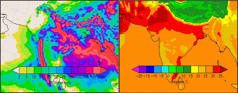
*INDIAN OCEAN DIPOLE – U.S Weather Agency since July 10 has declared Negative Indian Ocean dipole in the Indian Ocean while Madden-Julian Oscillation phase is also observed over Bay of Bengal and Arabian sea that can remain even during the third/fourth spell in the country. The sea surface temperature of Pacific ocean shows a slight cooling near the coast of South America which indicates towards weak La-Nina. In June, International weather Agencies hinted the possibility of formation of La-Nina later in the season.
*DUST CLOUD – Strong dust cloud presence over southern, moderate over central while weak over the extreme northern areas. There is no dust cloud cover over the northern areas as per today’s image.
Third Monsoon spell
On July 9, PWP mentioned the chances of third monsoon spell in the northern during the mid-week of July at ‘moderate’ and in coming days it was upgraded to ‘extremely high’, PWP also mentioned chances of monsoon activity in Sindh and south Punjab during the mid-week of July. On July 11, a date of July 15 (+1,-1 day error) was given for third spell in the northern areas. On July 12 night till July 14/July 15, weak monsoon activity was observed in Sindh and south Punjab, following are the total rain recorded for Sindh and South Punjab during that period;
- Mithi got 38 mm.
- Bahawalpur got 25 mm – South Punjab
- Chhor got 10 mm.
- Badin got 14 mm.
- Padidan got 14 mm.
- Thatta got 5 mm.
- Nawabshah got 8 mm.
- Karachi 2.1 mm
- Hyderabad got 1.7 mm
Since the third spell has just started in the northern areas therefore the highest rain recorded during the third spell (July 15 till July 17/July 18) will be given after the spell ends.
North – Rain, rain and rain

This spell which started from July 15 can continue till July 17/July 18. During that period, chances of rain with thunder/lightning in Islamabad, north-eastern Punjab (Lahore, Rawalpindi, Murree city, Jhelum, Gujrat, Faisalabad, Sialkot, Norwal, Sheikpura, Gujranwala, Attock, Mandi Bahauddin and few adjoining districts), Khyber Pakhtunkhwa (Abbottabad, Manshera, Haripur, Swabi, Swat, Peshawar, Landi Kotal, Hangu, Kohat, Khyber Agency, Khurram Agency and few adjoining districts) and Azad Kashmir (Muzaffarabad, Kotli, Mirpur and few adjoining areas with chances of isolated heavy falls).
The third spell which will continue till July 17/July 18 is weaker and isolated when compared to the second spell.
Central Areas – Missed thunderclouds!
South Punjab despite witnessing almost daily weak thundercloud formation near it, has not reported any traces. Partly/mostly cloudy with chances of drizzle/isolated shower in South Punjab (Bahawalpur, Bahawalnagar, Rahim Yar Khan, Vehari, Dera Ghazi Khan and adjoining areas).
Due to the advancement of western trough ’13’, north-eastern parts of Balochistan and adjoining south Punjab has witnessed daily formation of thundercloud since July 15, partly/mostly cloudy with chances of Zhob, Musa Khel, Bharkhan, Dera Bugti, Qila Saifullah, Loralai and few adjoining districts of Balochistan.
South – Under cloud cover
Chances of drizzle/isolated shower in parts of Sindh (Karachi, Thatta, Tharparkar, Mirpur Khas, Umerkot, Badin and adjoining areas) while passing clouds (increase during night/morning) in Sanghar, Khairpur, Sukkur, Gotki and adjoining areas,
Chances of showers in parts of Balochistan (Khuzdar, Awaran, Panjgur, Lasbella, and few adjoining districts), thundercloud activity for past days has been observed over these areas as well.
Fourth Monsoon spell

In PWP’s monsoon update of July 13, it was mentioned that fourth monsoon spell can start after the third spell, the fourth spell has a better coverage. On July 16, PWP gave a date for the fourth monsoon spell in the northern that is July 20 (+1,-1 day error).
During the fourth spell, northern Punjab, Azad Kashmir and parts of Khyber Pakhtunkhwa can witness heavy rain with chances of isolated very heavy rain in northern Punjab and adjoining Azad Kashmir while coastal areas & adjoining south-eastern parts of Sindh and North-eastern Balochistan & parts of south Punjab can witness light showers as per some models, no chances of proper rains yet in Sindh and south Punjab.
- Pakistan Weather Update will be updated once the third monsoon spell ends
Pakistan Weather Update & Monsoon Alert (July 20 – July 31)
-
Fourth Spell is bringing heavy rains to North
-
Fifth Monsoon spell seen for North
-
Wet week ahead!
Pakistan especially the northern areas are under the grip of monsoon rains after the end of third monsoon spell on July 18, the northern areas saw the strongest monsoon spell (fourth spell) of the season from July 20.
Factors – Present Conditions
*Western system ’14’ over the northern areas of Pakistan.
*Upper air cyclonic circulation over Indian Punjab another over north-east Madya Pradesh and adjoining north Chhatisgarh and south-east Utter Pradesh.
*Low pressure over north-western sector of Bay of Bengal.
Recap of the Third Monsoon spell
On July 9, PWP mentioned the chances of third monsoon spell in the northern during the mid-week of July at ‘moderate’ and in coming days it was upgraded to ‘extremely high’, PWP also mentioned chances of monsoon activity in Sindh and south Punjab during the mid-week of July. On July 11, a date of July 15 (+1,-1 day error) was given for third spell in the northern areas. On July 12 night till July 14/July 15, weak monsoon activity was observed in Sindh and south Punjab, following are the total rain recorded for Sindh and South Punjab during that period;
- Mithi got 38 mm.
- Bahawalpur got 25 mm – South Punjab
- Chhor got 10 mm.
- Badin got 14 mm.
- Padidan got 14 mm.
- Thatta got 5 mm.
- Nawabshah got 8 mm.
- Karachi 2.1 mm
- Hyderabad got 1.7 mm
The highest rain (above 40 mm) recorded in the northern areas during the third spell (July 15 till July 17/July 18) is as follow;
- Risalpur got 101 mm – Khyber Pakhtunkhwa
- Lahore got 55 mm (Mirsi Shah Reading) – Punjab
- Islamabad got 46 mm.
- Parachinar got 46 mm – Khyber Pakhtunkhwa
- Jehlum got 43 mm – Punjab
- Kakul got 45 mm – Khyber Pakhtunkhwa
- Mianwali got 43 mm -Punjab
- Dir got 40 mm – Khyber Pakhtunkhwa
The third monsoon spell started from July 15 and ended on July 18. Weak western trough ’13’ was also present during that period. After 24 hours, fourth monsoon spell hit the northern areas, it was also facilitated due to a western system – western disturbance ’14’.
Fourth Monsoon Spell
On July 13, PWP talked about the fourth monsoon spell right after the third spell, in the following days the chances of the fourth spell was upgraded in the northern areas. On July 16, PWP gave a date for the fourth monsoon spell that was July 20 (+1,-1 day error) and told that the spell has the potential to cause isolated very heavy downpour in parts of northern Punjab, Azad Kashmir and Khyber Pakhtunkhwa.
The spell started on July 20 with scattered heavy downpour along with isolated very heavy falls, following is the rain recorded (above 40) on the first day of the spell;
- Islamabad got 217 mm.
- Gujranwala got 130 mm – Punjab
- Sialkot got 111 mm – Punjab
- Rawalakot got 61 mm – Azad Kashmir
- Gujrat got 59 mm – Punjab
Northern Areas – Fourth Monsoon is significant!

“Alert: Scattered heavy rain likely in northern areas of Punjab, some parts of Azad Kashmir and few parts of Khyber Pakhtunkhwa”
Rain at times heavy and thunder/lightning in Islamabad, northern Punjab (Lahore, Rawalpindi, Murree city, Jhelum, Gujrat, Faisalabad, Sialkot, Norwal, Sheikpura, Gujranwala, Attock, Mandi Bahauddin and few adjoining districts), Khyber Pakhtunkhwa (Abbottabad, Manshera, Haripur, Swabi, Swat, Peshawar, Landi Kotal, Hangu, Kohat, Khyber Agency, Khurram Agency and few adjoining districts) and Azad Kashmir (Muzaffarabad, Kotli, Mirpur and few adjoining areas). There are chances of isolated very heavy rainfall in northern areas of Punjab and few parts of Khyber Pakhtunkhwa (Kurram Agency, Khyber Agency, Orakazi Agency, Kohat and adjoining districts) and some parts of Azad Kashmir (Rawalakot, Mirpur, Kotli and adjoining areas)
Central Areas – Passing clouds with hit-or-miss light showers
Since last few days thunderclouds are forming over Rajasthan and dissipate upon entering south Punjab while the western moisture causes thunderstorms to form over NE Balochistan under that influence partly/mostly cloudy with chances of drizzle/showers in some parts of South Punjab (Bahawalnagar, Bahawalpur ,Vehari, Dera Ghazi Khan and few adjoining areas).
During that period chances of showers/light rain in parts of Balochistan (Barkhan, Dera Bugti, Musa Khel, Zhob, Qila Saifullah, Loralai and few adjoining districts).
South – By least drizzle/isolated shower can occur!
Mostly dry weather as circulations are away from Sindh at the moment. Few clouds have been crossing into Sindh with some intensifying into a weak thundercloud. On July 20/July 21 chances of drizzle/showers in parts of Sindh (Karachi, Thatta, Tharparkar, Mirpur Khas, Umerkot, Sanghar, Khairpur, Badin and adjoining areas) while passing clouds (increase during night/morning) in Sukkur, Gotki, Jacoababad and adjoining areas.
Showers/light rain can occur in Khuzdar, Awaran, Panjgur, Lasbella and adjoining districts of Balochistan. Coastal areas of Sindh including Karachi has been witnessing daily drizzle since July 13, following are the rain stats;
- July 13 – 0.1 mm (Airport)
- July 14 – 0.1 mm (Airport)
- July 15 – 2.1 mm (Defence)
- July 16 – 0.1 mm (Airport)
- July 17 – 0.1 mm (Aiport)
- July 18 – 2 mm (Airport)
- July 19 – 3 mm (Defence)
Fifth Monsoon Spell
The fourth monsoon spell can weaken by July 22/July 23 in the north and in the coming week another monsoon (fifth monsoon) can aim towards the northern areas. PWP has observed some variation in the concentration of heavy rains in the fifth monsoon spell as COLA and GFS T574 shows the focus of heavy downpour in lower half of north Punjab that is Okara, Kasur, Sheikhpur, Faisalabad, Pak Pattan and few adjoining areas, COLA (not GFS) also shows light to moderate rains moving into south Punjab while on the other hand, US Charts shows (similar to past spells) concentration of heavy downpours over Islamabad, northern Punjab, Azad Kashmir and few parts of Khyber Pakhtunkhwa.
COLA and GFS (different version) show a low pressure moving towards Sindh during the last days of July and bringing heavy rains to much of Sindh including Karachi.
- Pakistan Weather Portal (PWP) will look into the fifth monsoon spell once the fourth spell ends!
Poll of the Week
Pakistan Weather Portal (PWP) wants to know that;

@KM :
GFS showing moderate to heavy rains in Sindh from 28th but these rains won’t be caused by the well-marked low. Will these rains be caused by tha UAC over Andhra Pradesh ? GFS is now showing the low pressure moving inland from 30th. Would it survive that long ?
GFS showing circulation forming in the Arabian sea and adjoining coastal Gujarat. The low will move once the circulation dies down, few days back that low was bringing rains during the first week of August as per GFS.
Northern Islamabad gets this much rain.If you live close to the foot hills of Margalla hills as they stall clouds,help make clouds and give relief rainfall which does not occur at Zero point.Zero point gets 1200 mm of rainfall.I recorded rainfall the past decade or so.
Hi
For Karachi its again the hopeless year. That low wont work.
Ahsan
AOA.. Babar bhai bahawalpur me havey rain kab ho gi…
Walikum Assalam,
Mostly moderate, with slight chances of isolated heavy falls in Bahawalnagar district from July 24 late night till two days
At about 12pm, another sweet rain in Lahore. Now its windy here. Bro, what is the forecast for coming weekend?
rain, rain, rain, rain AND rainnnnn. This is your forecast :p
Fifth spell’s intensity to weaken in north after tomorrow morning/mid-day though the spell can continue till July 27 and from coming week another spell is expected.
@KM :
What would be the intensity of rain in Sindh ?
Mostly moderate with slight chances of heavy falls in eastern districts.
Thanks bro!
what intensity is expected for karachi KM?
Chances of being Mostly moderate..
We have been witnessing a regular thundercloud formation across Sindh-Gujarat border for last few days but clouds dissipates without entering into Sindh. Please advise why this happens? Is there any requirement of visa for those clouds to be enter in Sindh through Khokharapar border and Wagah border decleared as visa free border? :D
Hahahah, yes they behaved like this yesterday. Today they have crossed into Sindh.
And did nothing :p
Getting reports that light showers in Tharparker district.
AOA. Babar bhai Sixth Spell starting from July 30.
Walikum Assalam, yes in the coming week.
GFS showing no rains in lower Sindh.
East or West, YAHOO is the Best……. aap logo ko pehle he suggest kar chuka hon GFS se jaan chorwa len…..Yahoo weather 15 din pehle se yahi forcast kar rha hai k no rain in lower sindh or KHI….GFS false hopes aap logo k mind men create kar deta hai aur aap loug Khiali Palao pakana shoru kar dete hen…..lagay raho Munna Bhai……
Mr.Saleem GFS changes whenever the weather changes. Right now GFS is showing light rain in Lower Sindh and so is weather.com. weather.com (yahoo follows weather.com) was showing good rains in Karachi few days back now they’re showing light rain just like GFS.
GFS is accurate, So far has been. No rain has occurred in Karachi yet.
GFS showing UAC/low dissipating just before entering Sindh. This always happens and will continue like this.
Dust cloud is too strong over Sindh. No thunderclouds can form here. If they do, they will dissipate quickly.
North and central parts are free from dust cloud.
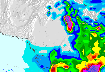
As of yesterday, north and central Pakistan was free of the Dust Cloud, as you can see from http://www.ecoseeds.com/dust-7-24-13.png but the leading edge of the cloud is splitting the monsoon moisture, so that the bulk is going out the Arabian Sea, and only about 1/4 is moving northward over Pakistan, as you can see at http://www.ecoseeds.com/clouds-7-24-13.png. Hopefully, the Dust Cloud will move away from the south, allowing rain to move over the land instead of being pushed out to sea.
Strong thundercloud over upper Sindh and adjoining Punjab.
Indeed a very large thunderstorm..
The downside of the Dust Cloud making the split, and forming an empty pocket in the north of Pakistan, is the possibility of the monsoon stalling over that area, causing floods. Daily monitoring of the pocket of the Dust Cloud with the moisture, might give advanced warning of future floods.
Time is up…No rains for Karachi this year..India and Northern Pakistan already got excess rainfall..Even in Gujrat near sindh got excess rains this year in July ..That low currently in india was the last BROKEN hope and in August the stretch of these rains will start reducing within the indian regions or sometimes in northern Pakistan.
Ahsan
Dear Craig,Tarim & Babar, You poeple are absolutely right about GFS. My opinion was just because of frustration against having no rains till nopw :(. Anyways, i must admit while reading your post i realy have learned alot about nature and its complications and its different shades and moods. Thank you all…indeed. :)
I am very concerned about the huge storm that is forming within the Dust Cloud pocket today, that you can see at http://www.ecoseeds.com/cloud-7-25-13.png with more moisture to back it up, Eastward in India.
i am really fed up that we have no rain here in karachi…. my patience have become subside now and now i m not relying any one and any org… for forecasting they r all rubbish and foolish……..tx.bye
THUNDER AND LIGHTNING + MODERATE RAIN IN KARACHI.
What is the updated dust cloud report?
It has weakened a little bit but will gain intensity again in coming days.
Well…… its seems that Allah has other plans for the city of Karachi…… or it may be because of our sins, especially because of the bloodshed on daily basis in Karachi….. i Pray to Allah for my forgiveness and for the people of Karachi…. and Pakistan and for all muslim Ummah….. But the positive part is we didnt experienced any heat in Karachi during Ramadan and all the way till today the weather is very plesent and breezy for Karachi….
So when will this DUST Cloud Weeken????
The dust cloud has started weakening over central Pakistan and will further weaken over Sindh in coming days. :)
Insha’Allah we will see good rains in August and September. :)
The dust cloud was very strong over Sindh and south Punjab in july resulting in little to no precipitation. It has started weakening now and will further weaken in the coming days.
I’ve also noticed the dust cloud over Tamil Nadu is strong which is the cause of very less precipitation in the state.
Thats Good News, but how come Foreca showing thunder shower in Karachi on Thursday Friday and Saturday.
GFS showing a low pressure moving towards Sindh from the 1st week of august. chances are still moderate.
Hi Tarim, Allaah ka shukar hai yaar k dust cloud weak ho raha hai…..thank you 4 sharing the positive news…..issi wajah se Baochistan mne bhi barish ho rahi hai like lasbella, gawadar, quetta etc. waise hum kab tak aik achi barish expect karen, i mean Eid wale din ya phir Eid k 3 din…..:D
As of now there’s no rain being shown during Eid. We can see some rain during the 1st week of august.
Yes therclouds are forming daily over SW Balochistan.
thunderclouds*
http://www.intellicast.com/Local/Weather.aspx?location=PKXX0008
@Everyone
The depression in BOB moves inland, currently over Orissa, it is expected to move in westwards towards Sindh. If it continues to move in this direction then it will reach Sindh by 2nd august.
Has anyone made contact directly with any officials at the Pakistan weather service at http://www.pmd.gov.pk and is anyone at the government weather office monitoring the daily impacts of the Pakistan-Arabia Dust Cloud on the rainfall and droughts?
No they don’t as far as I know.
Wow Tarim, thats really a wonderful wonderful news but tell us the difference b/w LOw & depression….depression is more powerful then low? or what……Allah kare khob Barish ho Allha ki rehmat wali…Amin.
UAC -> LOW -> Well-Marked low -> Depression
A depression is very powerful my friend.
We have seen a depression in Bay of Bengal after 3 years ( During monsoon season ).
Tarim, clouds tou kafi strong lag rahe hen…kiya heavy rain ho sakti hai sindh aur KHI men….what do you say?
Yes good chances of rain in Sindh from 2nd august.
AOA.. Tarim dost bahawalpur me rains nai ho rahin kab tak ho gi heavy rain…
chances from 3rd august.
The dust cloud will significantly weaken from 2nd august.
Chances of moderate rain in Sindh with few chances of isolated heavy rain in SE Sindh.
Tarim, pls tell update regrading the depression….is it still moving towards sindhor moved towards north east Pak…..i saw thick clouds near LHR. kiya depression ki intensity wohi hai ya kam ho gai hai?
The track is same as before. It has caused very heavy rains in central India. It hasn’t started weakening as of now. The intensity is maintained.
It would have weakened significantly by the time it reaches Sindh.
:( :( :(
Aakhir ye dust cloud kab jaan chore ga? Moon soon end hone k bad,,,, :(
1 month left now :P
Is anyone going to contact the weather officials in the Pakistan government so they can start daily tracking of the Dust Cloud?
The Dust Cloud can eat Category 5 cyclones, like GONU a few years ago, so when low pressures and the Dust Cloud battles, the Dust usually wins. The way for rain to get to Pakistan, is for the Cloud to move aside or for the Cloud not to get started in the first place. The only permanent fix, is to get the areas of Pakistan along the border with India that are producing the dust, revegetated to keep the dust out of the air.
Wish those with authority would take note of this :(
Dust cloud has started weakening and will further weaken in the coming days. Hopefully we will see meaningful rains ( which I highly doubt ) in a few days.
Dear Craig, appreciate and thank you for your valuable concern on dust cloud issue. The PMD email address i have found for any feedback/suggestions is ‘webmpmd@gmail.com’.
Regards,
Tarim, is the sixth spell in Northern areas still there or has it weakened?? Haven’t seen any rain in my place since 2 days ago. It rained the day 6th spell started and then nothing. I was wondering if it is over already??
It will continue till 3-4 days with occasional gaps.
And we haven’t seen rain in our place since the start of monsoon season :)
is men hansne wali tou koi bat nahi :( :( :(
You should come here for the summer, take a vacation in Murree or the beautiful Northern areas.. :)
Even this depression fails to bring meaningful rains to Sindh. Sad !
You know the culprit, what can be done about it?? Sab ikhtiyar waale soye hue hain .. :(
In 2009, a depression formed and brought very heavy rains to Sindh especially Karachi. 245 mm was recorded in 4 hours. The depression had weakened to a low pressure by the time it reached Sindh. I was so excited about this depression as it was the 1st monsoon depression that formed since 2009.
As of now the Depression is over Eastern Madhya Pradesh and will continue to move in a WNW direction and weaken gradually.
My God, as per Craig, The Dust Cloud can eat Category 5 cyclones??? this is extreemply alarming and it seems that concern people at PMD are sleeping as i have not seen any comments of any PMD official on the issue….. :(
Haaye Babar ‘Kahan ho tum ko dhond rahi hen, Ye moonsoon aur ye Hawayen, Aa ha OO ho’ :( :( :(
Tarim, The email address of PMD is mentioned below for any feedback/suggestion, could you please get theie feedback on dust cloud issue.
‘webmpmd@gmail.com’
Regards,
The Dust Cloud today has moved far eastward into India today, so any moisture is probably going to get blocked and moved out to the Arabian Sea. However there is another small clear pocket forming in the north along the border with India, so some rain might sneak in that way.
I am hoping that someone will contract the government of Pakistan, so they can monitor the situation daily, and start making a plan to cure the cause of the Dust Cloud before it causes either long term drought or massive floods again.
I think the barren area that is creating the Dust Cloud, the revegetation work could be paid for by other countries that need carbon credits–credits that would be generated by the native Pakistani plants in the soil, once they get established.
Look who’s back :)
:)
WoW The Babar Cyclone has finally come back….. G Aya Non Babar Pi Jaan…. :(….. :)….just saw a weather report on PTV where PMD director has said k in coming 3 days there would rain in 90% area of the country….but wondering k 90% ME khi Bhi included hai k nahi…. :(
It’s raining even in Sibi including most of Balochistan but no rain in Sindh.
Another low pressure may form in the BOB from 7th august.
Perhaps two things could help manage the Pakistan Dust Cloud in the future–First a group of people who have an interest in the future elimination of the Cloud, with a name like the Pakistan Dust Cloud Group, or something like that.
Second, the Confluence.org project for the country of Pakistan needs to be completed, so that a whole country overview can be made from the photographs.
If you look at the photo from the Sindh for example at http://www.confluence.org/confluence.php?lat=26&lon=70 you see that there is a delicate balance between the soil being covered by the native vegetation, and that if that thin cover is not protected, that would allow the soil to get airborne.
There are 86 photo-points for Pakistan and only 27 have been completed at http://www.confluence.org/country.php?id=145.
As per PMD heavy rain can caused flash flooding in parts of Balochistan and local nullahs can oveflow because of heavy down poor.
Tarim / Babar, really failed to undestnd how this happened? i mean sindh aur KHIk liye aap loug contineously yahi keh rahe hen k Dust cloud ki waja se rain clous aagay nahibarh rahe then Balochistan ko rain clouds kis rout se approach kar rahe hen???
:( As informed by Craig and as expected, the dust cloud has prevented the low to move into sindh and now only thing we can do now is to wait, wait & wait : ( :( :( :( :( :( :( :(….huge disappointment.
No point in waiting. The next low pressure won’t bring rains to Karachi either.
Strong thundercloud has formed North of Karachi.
Thundercloud is right above Karachi and still no rain. This is what I call pure bad luck.
Rain is likely in Karachi on August 2 late/August 3.
Yes, it is right over Karachi but surprisingly not a drop of wate has been felt……. this is somthing else not a blody dust cloud issue, this certainly something elase by very mysteriou……………
Babar, Hai koi justification? :(
Local conditions also play their part in favouring rain.
Anyhow rain is expected in Karachi, Low pressure is near Sindh and south Punjab.
Babar, dust cloud ki present position kiya hai? agar KHI men achi barish ho jati hai tou dust cloud se jaan chotegi k nahi?
Moderate intensity dust cloud currently. It is expected to weaken further.
Tarim is right.
Rain started in hyderabad and adjoining areas
Rain concentration will be better over Karachi tomorrow.
@KM :
You know I said we should see july 18 2009 like rain this year. A depression formed in july 2009 and this year depression formed again and it is currently over rajasthan just like 2009, So, what do you think :D
Hahaha that is awesome, lets see what happens.
At this moment, models continue to show below 20 mm rain in Karachi.
How much rain was being shown by models in july 2009 ?
I recall 60 mm.
Thunderclouds dissipating over Karachi now. I can’t believe they didn’t even caused light rain :S If these clouds were over Northern Pak it would be raining heavily there. What the hell is with this weather :/
Why is it often that we see a thundercloud over an area and it does not rains while some times it does?
Heavy rain started here at 6:30 :D
Raining heavily here (though not like 2009) just like 2009 when there was no sound of thunder and no lightning like in 2009.
Rain stopped. Strong nimbus clouds forming in the North.
Amazingly, there is no thundercloud over Karachi right now. Strange weather of Karachi and amazing at the same time :D
Tarim,has the depression entered in sindh or entered in balochistan causing heavy rain there?
Hasn’t entered yet I think.
Yes beatiful nimbus couds….lovely.
AOA..Babar bhai bahawalpur me havvey rain kab ho gi and today rain ho sakti hai
Very heavy rain with 40 km/h winds. wind direction NE.
Rain stopped. Another spell starting in 10 minutes.
It was really just an excellent rain… i enjoyed a lot…..
Rained cats and dogs. :)
Wow, Wow, Wowwwwwww, what a spell that was……amazing spell…..spurb downpoor…..sahi keht hen “Allah Jab deta hai tou Chappar phaar kar deta hai” Tarim you were absolutely right k ye 2009 ka repetition hai instead i would say sequel hai :D . Babar was saying yesterday k arond 20mm rain forcas but jo rodas ka haal me abhi dekh kar aya hon ye kisi tran bhi 50 ya 60mm se kam nahi hoi hai…..pls check and confirm……. :D :D :D :D :D :D :D :D :D :D :D :D m so happy…….
” Subhan Allah Wa b Hamdi he Subhan Alah hil Azeem”
:D
any predictions for tonight and tomorrow?
what about the eid holidays? Weather.com and many sites are showing rain on eid holidays
Met office of pakistan said
Landhi 56mm , Nazimabad 42 and airport 22 mm….
no one here at peak time :(
Rain to continue till 4 aug. chances of rain from 8th
In karachi from 8? has low pressure been formed at BOB?
And intensity till 4 august?
Tarim/Babar, bloody dust cloud ka ab kiya haal hai…..hosh thekenay aa gaye hon gay ab tou?……. :D
hahaha it has weakened further :)
Clouds have changes direction from NE to SW. I think the thunderstorm over Sindh has curved back.
more predictions?
@Shabib
Intensity will decrease from tomorrow. A low expected to form in the Bay from 7th.
so when rain will come to karachi? it has to travel long distance :D
Chances still poor.
Where’s KM ? :s
The Baba cyclone ab apna darshan nahi karayen gay coz ab un k pass ye bata ne ka koi chance nahi k ;cloud is dissipating in E/W/N/S of KHI, dust cloud ki waja se KHI me Barish nahi ho sakti, LOw sindh i traf nhai aye ga etcetc & etc’ now no bad or negative news to tell in bucket of Babar….issi liye he is reluctant to come on board…. :D :D :D
hahahahaha
Yes Saleem keep on making assumptions!! :P
Eid ka chaand :o
Power outage. :P
I was wondering on what Craif had said, “The dust cloud can eat a cyclone of category 5” , if it is tre then how come the present spell of rain has occured & not eaten by the dust cloud i.e. still persist???????
Conlusion : No one can predict about NATURE accurately as it has very mysterious kind of attitude, like yerterday night we had saw that strong thunder cloud was right over KHI but not a single drop of water had been felt BUT on v.next morning v.heavy downpoor occured all of a sudden as also mentioned by Tarim that low/clouds direction was shifted to S/W from NE.
Bro, the dust cloud over UAE, Dubai and Saudi Arabia is twice or thrice as strong as the dust cloud over Sindh. That’s why !
These are desert areas that’s why the dust concentration is always strong over them.
@KM :
Mr. Rajesh forecasted rain on Sunday as well, with heavy downpour in Karachi tonight.
What do you say ?
PWP also wrote in the ‘Monsoon of Pak’ page yesterday that the current rain spell can last till August 4 in Sindh, after tonight its intensity would weaken. So yes there are chances of heavy rain tonight also thunderstorms continue to form over eastern and upper Sindh, watch for their movement. But after tonight the chances would start to decrease.
Yeah I figured your area was a feeder trip victim :p No power outage in my area the entire day :D Not even load shedding :)
Thundercloud over Karachi weakening. Another strong thundercloud forming East of Karachi. low pressure trough expanding towards Oman.
Has the low pressure weakened into an UAC or is it still a low ?
It has weakened.
Yesterday, PMD forecasted isolated light rain in Sindh only. Today they forecasted widespread heavy rains in Lower Sindh and gave urban flash flooding warning in Karachi, Hyderabad and Larkana divisions :P
babar when rain will come in bahawalpur
Drizzle/showers were recorded in Bahawalpur during the last two days. More chances of showers/rain persists.
please reply me now
raat ko taiz barish ho sakti hai?
karachi main?
Yes there is a possibility
rain will come in bahawalpur this tonight.it is true?
There are chances of rain/showers – watch for the thundercloud over upper Sindh.
babar bhai what will be the direction of thunder cloud….?will it come to karachi before dissipating?
It is expanding over all parts of Sindh including Karachi at this moment strong part is over eastern Sindh.
Welcome on board Dear Babar, feel sorry to hear power outage in your area…..Allah Main sab ki muskilaat ko aasan karen aur apna khace fazal rakhen…Amin.
Waise i would say, what a twist in our opinion just 24 hrs ago we were complaining so badly and disappointed and then…………….Wow…………………..m truly surprised and speech less. ;(
Thank you Saleem.
The rain was very likely today, but crossing 100 mm was not being shown on charts and models.
TarimFS k ab kiya kehne hen?………….was there any predictions from them regarding todays heavy downpoor, i believe, NO…….. :D
*GFS
where is everyone?