
Post Monsoon system no longer under watch for depression

The Sindh province usually does experiences a post monsoon spell in some years during the month of September due to the formation of a weather system (upper air cyclonic circulation) in the Arabian sea or a weather system (low pressure) over western India. According to weather history, Sindh has experienced tropical activity in September or October which do fall in the category of a post monsoon.
Background: Post Monsoon and Tropical Activity
On September 1, PWP mentioned in the Monsoon of Pakistan page that a weak post monsoon activity can occur in Sindh in Middle of September (first post spell occurred on Sept 13 which brought 13 mm rain to Mithi). While another spell can occur in coming days as a low pressure over lower central India is moving in a SSW direction. On September 8, PWP mentioned in it’s Pakistan Weather Update & Tropical Watch that a tropical activity can take place in the Arabian sea in the third week of September, a system can intensify near Maharashtra coast however as we see that has been now scheduled for the fourth week.
Update on September 23 at 10:00 pm PKT – Watch for a low pressure!
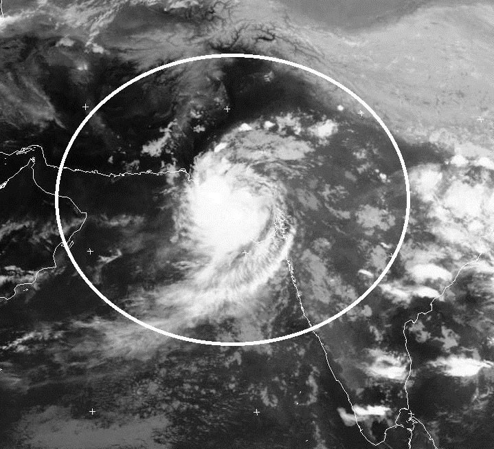
On September 19 an intense circulation over north Bay of Bengal intensified into a low pressure over Indian state of Odisha and adjoining west Bengal, it continued to move in a westward direction though later changed it’s direction to SSW. On September 21, it was over south of Indian state of Madya Pradesh as it tracked in a SSW direction with a circulation south-west of the system.
- COLA AUS: On September 24, the system could track towards Maharashtra and adjoining Gujarat coast and from September 26, it will start moving towards Gujarat coast. On September 27/September 28, it will be near Gujarat and adjoining Sindh coast with possible intensification into a minimal depression.
- GFS UK: It is showing similar to the COLA Model, with back and fourth movement (possible minimal depression) around the Gujarat and adjoining Sindh coast with complete dissipation during the first week of October near Gujarat-Sindhi coast.
Rain for Sindh?
“Warning: Thatta and Badin can experience heavy downpour and strong gusty winds along with rough sea around September 27/September 28/September 29, fishermen should obey the government’s warning!”
Hot temperatures with chances of drizzle/showers with thunder/lightning in Tharparkar, Badin, Thatta and Umerkot districts till September 25. Increase in activity can happen afterwards – On September 27/September 28 (+1,-1 day error), rain with thunder/lightning along with gusty winds can occur in Thatta, Badin, Tharaparkar, Umerkot, Mirpur Khas, Tando Muhammad Khan, Hyderabad and few adjoining districts.
Coastal areas of Thatta district (Keti Bandar and Shah Bander), Badin and few adjoining areas can experience heavy downpour and strong gusty winds along with rough sea during that mentioned period as strong thunderstorms will be near its coast.
What about Karachi?
Hot temperatures will continue this week, on September 27/September 28 (+1,-1 day error), rain with gusty SE/NE winds can occur in the metropolis with high tides. COLA shows >15 mm rain while GFS shows >10 mm rain during that period. According to the Hong Kong Observatory, Karachi’s average September rain is 22.8 mm.
Update issued on September 26 at 10:00 pm PKT
“Post Monsoon system is no longer under the watch for tropical depression!”
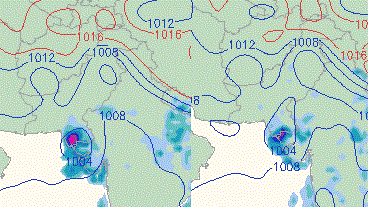
COLA and GFS maintained the tropical depression run till the morning of September 24 however after that they have shown that an incoming western trough ’22’ would impact the overall track of the system, rain can occur in the northern areas of Pakistan in coming days.
According to the numerical models, the low pressure instead of moving in a WSW/SSW direction (entering Arabian sea), it has moved in a WNW direction and now lies over western Gujarat over the Kutch area of the state, it has further intensified. The process of re-curve can start from tomorrow evening/night and the system can move in a brief NNW direction before moving in a ENE direction. After that COLA shows the weakened system to again enter eastern Gujarat in a SSE direction.
Despite change in direction, there are chances of post monsoon spell in parts of Sindh though the intensity would be less now. On September 27, Rain with thunder/lightning at times isolated heavy with strong winds can occur in eastern districts (Tharparkar, Badin, Thatta, Umerkot and Mirpur Khas district). Chances of showers/rain in Hyderabad, Sanghar, Khairpur, Sukkur and adjoining few district. Slight chances of drizzle/isolated showers in Karachi, the temperatures will remain high due to lack of sea breeze as eastern winds would continue to dominate the city. On September 28, more rain can occur in the eastern districts of the province, decrease in clouds in other parts of Sindh. Following is the amount of rainfall recorded in the province due to this activity;
- September 24
Nagarparkar got 17 mm.
Diplo got 16 mm. - September 25
Nagarparkar got 34 mm.
Diplo got 5 mm. - September 26
Nagarparkar got 4 mm.
Mithi got 3 mm.
Badin got 2 mm. - September 27
Nagarparker got 97 mm.
Mirpurkhas got 45 mm.
Islamkot got 41 mm.
Chhor got 22 mm.
Diplo got 17 mm.
Karachi got 11 mm.
Mithi got 9 mm.
Nawabshah got 4 mm.
Badin got 3 mm.
Hyderabad got 1 mm.
Is cyclone forming?
No numerical model shows any immediate cyclone formation. Following is the list of tropical development seen in the month of September during the 21st century;
- On September 25, 2001 – A depression later strengthening into a Cyclone over Arabian sea. It’s trough brought clouding to SE Sindh.
- On September 30, 2004 – A depression formed near Indian coast that late intensified into Cyclone Onil bringing more than 100 mm rain to Thatta.
- On September 21, 2006 – A depression formed over northern Arabian sea near Gujarat coast that intensified into Cyclone Mukda, it affected no land and dissipated over water.
Articles you may be interested
- October storminess: Cyclone Onil came with full force!
- A Cyclone is coming to Pakistan this year!
- Cyclone Yemyin – The untold story!
Tropical Poll
Pakistan Weather Portal (PWP) wants to know;
