, , , , , , , , , , , , , , , , , , , , , , , , , , , , , , , , , , , , , , , , , , , , , , , , , , , , , , , , , , , , , , , , , , , , , , , , , , , , , , , , , , , , , , , , , , , , , , , , , , , , , , , , , , , , , , , , , , , , , , , , , , , , , , , , , , , , , , , , , , , , , , , , , , , , , , , , , , , , , , , , , , , , , , , , , , , , , , , , , , , , , , , , , , , , , , , , , , , , , , , , , , , , , , , , , , , , , , , ,
184 comments on Pakistan Weather Update & Monsoon Alert (June 28 – July 12) – Updated on July 4

Pakistan Weather Update & Monsoon Alert (June 28 – July 12) – Updated on July 4

monsoon-2013-pwp

  • Monsoon hits the north on June 27

  • Frequent rains since June 25

  • Rains return after 7 days!
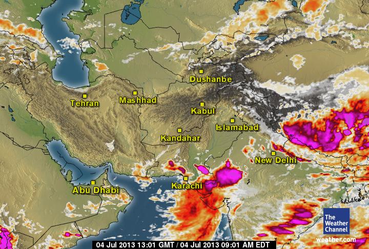
New Update is issued on July 4 – ย Go Below

Temperature and Precipitation till July 5

Monsoon has advanced into the northern areas of the country mainly Azad Kashmir, Khyber Pakhtunkhwa and northern Punjab on June 27. Last rains (pre-monsoon) that occurred in the country was on June 16/June 17. After that rain (monsoon) again started falling from June 25. On June 26, 65 mm rain fell in Murree, Punjab while on June 27, 71 mm rain fell in Bannu, Khyber Pakhtunkhwa. The first spell of monsoon rains is mostly moderate and it has become significant only due to the western trough ’11’, the rains can continue till early first week of July. Across the border, North-western India had one of it’sย worst flood in yearsย with fresh heavy rain falling near the flood-hit areas.

Factors โ€“ Present Conditions

*Western trough โ€™11โ€ฒ is over the north-western areas of the country.

*Low pressure over south-east Utter Pradesh (India).

Emerging Factors – Effect on Monsoon
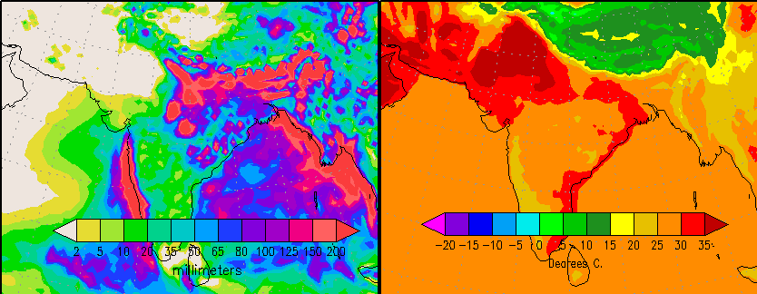
Sea surface temperature - Dust cloud
Sea surface temperature – Dust cloud

*INDIAN OCEAN DIPOLE –ย Sea temperatures in the western Indian ocean near African coast are cool while the temperatures in the eastern Indian ocean near Indonesia are high. Slight trend towards negative Indian ocean dipole.

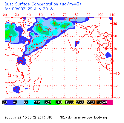
*DUST CLOUD – Strong dust cloud presence over southern, moderate over central while weak over the northern areas.

Pakistan Weather Portal (PWP)โ€™s forecast

โ€œNotice:ย This is the forecast fromย Pakistan Weather Portal (PWP), we are 80% confident with this prediction.ย There will be slight variations in our forecast as certain meteorological factors develop and fade as time passes by and these factors are too isolated to be noticed on numerical charts or models. According to various meteorological parameters this forecast has been made.โ€

PWP's expected condition on June 28 night/June 29
PWP’s expected condition on June 29 night/June 30
  • The Article would be updated when once the first spell is over!

Pakistan Weather Portal (PWP) successfully predicted the onset of theย pre-monsoon activity in the country as PWPโ€™s pre-monsoon forecast was around June 14 (+2,-2 day error), PWP on June 4 told that scattered to widespread pre-monsoon can occur in the country and on June 8 PWP told that very heavy rainfall can occur in NE Punjab though SE Sindh did not get the ‘expected intensity’ ย rains.ย For the onset of Monsoon, PWP in it’s Monsoon Vย published on June 6 did say that monsoon onset can happen during the last week of June/first week of July while on June 23 (upgraded the chances of monsoon to ‘extremely high’ on June 26), PWP said that monsoon onset can occur in the northern areas on June 26 (+1, -1 day error), isolated rains started June 25 while monsoon advanced into these areas on June 27.

As of 5:00 pm PKT June 28,ย Various models, numerical charts and other meteorological parameters observed by PWP for the track of developing weather systems are shown as;

*On June 22, a low pressure formed over Bay of Bengal and moved in a WNW direction towards Odisha coast on June 24, the next day it lied over North Chhattisgrah. On June 27, it was over south-east Utter Pradesh with some deepening. This low pressure had an encounter with the western trough ’11’ over the north-western areas of Pakistan on June 27 that will cause the low to persist till next two to three days over the some area, the moisture will cross into Nepal and China. The interaction with the western system can cause some thunderstorms to form north-eastern parts of Pakistan on June 28 night/June 29. There is another possibility (only GFS) of a circulation/low forming over the central parts of India that will merge with the monsoon axis over Himalayan ranges over the northern India during the first week of July.

First Monsoon Spell

โ€œAlert:ย ย During this period (June 28 night till June 30 night), isolated heavy rainfall with strong winds (>56 km/h) can occur in Khyber Agency, Landi Kotal, Orakzai Agency, Khurram Agency including Parachinar,ย Abbottabad, Haripur, Manshera, Murree, Muzaffarabad, Rawalpindi, Attock, Lahore, Sialkot, Kasur, Sheikhpuraย and adjoining cities areas. The first spell of monsoon is mostly moderate.โ€

Islamabad

Rain coverage in the north – above 25 mm seen

Rain with chances of isolated heavy falls can occur in capital from June 28 night till July 1 with intervals. Rain will be accompanied by thunder/lightning and strong winds (>56 km/h).

Day mercury is expected in Islamabad;

  • 34ยฐC to 38ยฐC in Islamabad.

Khyber Pakhtunkhwa (FATA) and Balochistan

Most rain has occurred in Khyber Pakhtunkhwa during the current spell. Rain with thunder/lightning along with strong winds (>56 km/h) can occur in Khyber Pakhtunkhwa. ย There are chances of isolated heavy falls in Khyber Agency, Landi Kotal, Orakzai Agency, Khurram Agency including Parachinar,ย Abbottabad, Haripur, Manshera.ย The provincial capital of Balochistan Quetta would remain dry with partly cloudy sky.ย There are chances of isolated rain in Khuzdar, Kalat, Awaram, Zhob, Musa Khel, Barkhan and few adjoining districts during this period.

Following are the day temperature expected;

  • 34ยฐC to 37ยฐCย Peshawar.
  • 32ยฐC to 36ยฐCย Quetta, remains unchanged.

Punjab

In Northern Punjab:ย Lahore, Faisalabad, Murree, Gujranwala, Rawalpindi, Sargodha, Sialkot and other adjoining cities. Rain with chances of isolated heavy falls on June 28 night till July 1 with thunder/lightning and fast to strong winds (>56 km/h). There are chances of isolated heavy falls inย Attock, Rawalpindi, Jehlum and few adjoining areas.

Following is the day temperature forecast for Northern Punjab;

  • 34 ยฐC to 38ยฐC in Lahore.
  • 41ยฐC to 45 ยฐC in Faisalabad.
  • 21ยฐC to 26ยฐC in Murree.

In Southern Punjab:ย Bahawalpur, Bahawalnagar, Multan,ย Rahim Yar Khan, D. G. Khan and other adjoining cities are expected to remain dry with passing clouds. ย However showers with windy conditions can occur in Dera Ghazi Khan district on June 28/June 29 while isolated shower can occur in Bahawalnagar districts on June 29/June 30. Overall the temperatures are high in this part of Punjab.

In Southern Punjab, day temperatures will be higher than Northern Punjab;

  • 40ยฐC to 43ยฐC in Multan.
  • 41 ยฐC to 44 ยฐC inย ย Bahawalpur.

Sindh

In Upper Sindh:ย Sukkur, Larkana, Jacobabad, Kashmore, Nawabshah and other adjoining ย cities. Mostly dry conditions are expected with increase in clouds during the night in NW parts of upper Sindh. Overall the temperatures are high in this part of Sindh.

Following is the range of day temperatures expected in this part.

  • 43ยฐC to 45ยฐC in Sukkur.
  • 42ยฐC to 46 ยฐC in Larkana.
  • 43ยฐC to 47 ยฐC in Nawabshah.

In South-eastern Sindh:ย Mirpur khas, Umerkot, Tharparkar, Badin and Hyderabad. Mostly dry weather expected with increase in clouds during the night/morning ย while there are chances of showers with thunder/lightning in Tharparkar district.

Following are the day temperatures, high temperatures are prevailing in this part of Sindh as well.

  • 36ยฐC to 43 ยฐC in Hyderabad.

In coastal Sindh:ย Karachi, Thatta, Keti, Shah Bandar and other coastal localities.ย ย Mostly dry weather expected with cloudy night/morning along with chances of drizzle.

Temperatures have returned to their calm level in the coastal belt.

  • 33 ยฐC to 36ยฐC in Karachi.

Second Monsoon spell

The first spell will weaken significantly on July 1 though since the monsoon has advanced into the northern areas therefore the moist-laden winds will prevail with chances of drizzle/isolated showers in few areas of northern areas. The second spell can hit the northern areas during the late first week of July/second week of July. Proper monsoon rains in the central and southern areas of the country are not seen at moment.

People are eager to know when will they get their share of rains! Monsoon mostly advances into Karachi during the mid-week of July.

Pakistan Weather Update & Monsoon Alert (July 4 – July 12)

  • Monsoon rains returning to North!

  • South experiences showers

  • Mid-week, Monsoon to advance further Pak

Precipitation and Temperature till July 11

Monsoon onset happened on June 27 in the northern areas.ย PWP in it’sย Monsoon Vย published on June 6 did say that monsoon onset can happen during the last week of June/first week of July while on June 23 (upgraded the chances of monsoon to ‘extremely high’ on June 26), PWP said that monsoon onset can occur in the northern areas on June 26 (+1, -1 day error), isolated rains started June 25 while monsoon advanced into these areas on June 27.

Factors โ€“ Present Conditions

*Low pressure over East Rajasthan and adjoining Madya Pradesh.

*Fresh circulation can form in the Bay of Bengal on July 6/July 7.

Recap of the first monsoon spell

The rains were isolated heavy in intensity especially over western Khyber Pakhtunkhwa and northern Punjab. Following are the highest rainfall recorded the first monsoon spell (above 40 mm);

  • Bannu got 71 mm – Khyber Pakhtunkhwa
  • Rawalpindi got 68 mm – Punjab
  • Murree got 65 mm – Punjab
  • Kakul got 64 mm – Khyber Pakhtunkhwa
  • Mianwali got 58 mm – Punjab
  • Saidusharif got 55 mm – Khyber Pakhtunkhwa
  • Kotli got 53 mm – Azad Kashmir
  • Balakot got 53 mm – Khyber Pakhtunkhwa
  • Muzaffarabad got 42 mm – Azad Kashmir

The monsoon spell started from June 25 with weak intensity and gained strength on June 27 and weakened significantly on June 30 though isolated rain continued till July 1. After July 1, temperatures started rising in the some parts of the country. The first monsoon spell was more focused in Khyber Pakhtunkhwa due to western trough ’11’ however top cloud temperature showed that monsoon moisture played a significant role in the rains.

Second Monsoon spell

On June 28, PWP said that the second spell can occur in the northern areas during the late first week/early second week of July. On July 1, PWP upgraded the chance of second spell at ‘poor’, in the following days it was further upgraded. On July 2, PWP gave the date for the second monsoon spell that was July 7 (+1,-1 day error). On July 3, PWP upgraded the chance to ‘very high’ and the next day it was upgraded the chance to ‘extremely high’.

Northern Areas

“Alert: Chances of isolated very heavy downpour in few areas of NE and adjoining North Punjab (Lahore, Sialkot, Gujranwala, Sheikhpura, Mandi Bahaudin and few adjoining areas) on July 8 till July 10.”

Above 50 mm rain in North

Mostly dry weather expected till July 5 with chances of thundercloud formation near northern Punjab that can being drizzle/showers with thunder/lightning. Second Monsoon spell is expected from July 7 (+1,-1 day error), rain with thunder and lightning along with fast/strong winds can occur in many places of the northern areas. Rain at times heavy (isolated very heavy in few areas) can occur on July 8 till July 10 early in the Northern and North-eastern districts of Punjab (Lahore, Sialkot, Gujranwala, Faisalabad, Sheikhpura, Rawalpindi (including Murree city), Jhelum, Gujarat, Mandi Bahauddin and few adjoining areas). During the second spell, 45 mm till 110 mm is being showed in various areas of upper Punjab.ย Rain with thunder and lightning is also likely in Islamabad especially during July 8 and July 9.

North-western areas of Punjab that is Attock, Sargodha and adjoining areas can also witness rain with thunder and lightning during this period.ย Rain with thunder/lightning also likely in Azad Kashmir including Muzaffarabad however there are chances of isolated heavy falls in Kotli, Mirpur and adjoining cities of the state.

Rain with thunder and lightning can occur in Peshawar, Abbottabad, Manshera, Haripur, Swabi and adjoining districts with chances of isolated heavy falls in Hangu, Kohat, Khyber Agency, Khurram Agency and lower Peshawar district. The second spell starting from July 7 (+1,-1 day error) can end on July 10 evening/night.

Central Areas

Thunderclouds near Sindh on July 4

Mostly dry weather expected in this part (South Punjab and Northern Balochistan) of the country however there are chances of drizzle/isolated showers with thunder and lightning in Bahawalpur, Bahawalnagar, Rahim Yar districts of south Punjab due to the closeness of a thundercloud formation over West Rajasthan. Partly/Mostly cloudy weather can occur in Multan, DG Khan and adjoining areas.

Partly/Mostly cloudy conditions with chances of drizzle in Barkhan, Musa Khel districts of Balochistan while dry with passing clouds in Quetta.

Southern Areas

Thunderstorms due to a circulation associated with low pressure over East Rajasthan and adjoining Madya Pradesh, these thunderclouds would be crossing south Gujarat and adjoining Sindh till next few days.ย Chances of isolated shower/light rain in Karachi, Tharparkar, Umerkot, Sanghar, Khairpur, Badin, Jamshoro, Thatta and adjoining areas.ย In Balochistan, there are chances of drizzle/isolated showers in Awaran, Khuzdar, Panjgur and adjoinig districts of Balochistan.

Monsoon Advancing into Southern and Central areas?

GFS shows UAC/Low over central India on July 12

Monsoon moisture is continuously penetrating into Sindh while it is weak in South Punjab, monsoon can advance into Sindh and South Punjab during early mid-week of July as a fresh low pressure can bring rains to Sindh on July 13/July 14. PWP will monitor this situation again.

Poll of the Week

Pakistan Weather Portal (PWP) wanted to know your thoughts and by far 160 votes have been casted,ย 30.6% people believe that monsoon will cover the country by the last week of july while 20% believe that it will happen during the second week of July;


184 responses to “Pakistan Weather Update & Monsoon Alert (June 28 – July 12) – Updated on July 4”

  1. zahid syed Avatar
    zahid syed

    babar bhai what will be the weather in sukkur in coming days till 15 jully

    1. PWP Avatar

      Mentioned till Early July.
      Mostly dry weather expected in the city with passing clouds as no major rain is seen.

  2. Waseem Ahmed Avatar
    Waseem Ahmed

    Very much detailed forecast..
    I want to ask 2 qustions
    1>there are strong winds in sindh from some days when will they end?
    2>can we say no rain coming in sindh in july?
    Plz answer in detail

    1. PWP Avatar

      Thank you Waseem :)
      1. These strong winds are mostly due to the westerlies that has weakened the already weak easterlies over south-east Sindh. They would end once the WD ’11’ weakens and moves way.
      2. No there are slight chances of rain in Sindh in July but not the major chances that we saw in 2011 and late 2012 monsoon. Monsoon does not start in June in Sindh, it mostly starts during the second or mid-week of July. We still have time.

  3. Tarim Avatar
    Tarim

    That dust cloud concentration over Sindh is too strong.
    I don’t think Sindh is seeing any Monsoon rains in July. Sad !

    1. PWP Avatar

      Yes.
      I am little optimistic about rains though not about drenching rain but some stable rain can occur. Monsoon does not start in June in Sindh, it mostly starts during the second or mid-week of July. We still have time.

      1. Tarim Avatar
        Tarim

        Dust cloud is showing no signs of weakening.

  4. Aqib Avatar
    Aqib

    august and september are the real monsoon months of karachi :)

    1. Tarim Avatar
      Tarim

      In which we barely see 150+ mm :p

  5. asif Avatar
    asif

    in the begining there are chances of monsoon rain in sindh because of high temperature. But now the south western winds are so strong in karachi which resist a hot weather.Therefore not any chances of monsoon rain.south western winds which bring a cloud with him are not responsible for any rain in karachi due to the low altitude of karachi.It only causes a drizzling and fast wind.Rain is always come when hot wind mix up with the cold wind of sea.This typs of phenomenon is not occur in karachi.

  6. Kazim Rizvi Avatar
    Kazim Rizvi

    hmmmm

  7. cidsonytv Avatar

    Dust Cloud phenomena is baseless. According to Jim Andrews (Accuweather.com Expert), there is no link between Monsoon and Dust Clouds. Here is the answer, he gave to my question via email. Kindly read it.

    Dear Kazim,

    Some of the information found in the reader article may not be accurate. It is known that airborne dust can suppress deep convection over tropical oceans, lowering the frequency of tropical cyclones. This has been observed for the Atlantic Ocean. Could this be true over land? Well, I guess so. However, dust over Pakistan may also imply lingering influence upon regional weather by the Westerlies, which by itself would likely yield low rainfall in and near Pakistan.

    The other argument (splitting of the Monsoon) strikes me as spurious. As you know, the rain giving monsoon is a SW current; the easterly flow that he depicts is high aloft.

    As for desertification and the drought feed-back cycle, I do not know if a massive tree-planting mission would have any meaningful bearing. Most of the land between Pakistan and west Africa has been desert for thousands of years.

    I hope this help you to better understand.

    Jim

    1. PWP Avatar

      Craig Dremann’s dust cloud theory has some weight though since its new therefore it needs a further research to establish a direct link with the monsoon season though monsoon’s behavior and frequency depends upon several other atmospheric factors (excluding the Dust cloud).

      The way he has compared the dust cloud with the thunderstorm movement is interesting.

    2. Craig Dremann Avatar

      Dear Jim and All,

      Thanks for your comments. I have posted a reply six spaces down, with a link to the June 29, 2013 Dust Cloud image, along with my predictions of more stalling of the monsoon in India which may continuing the floods, and the lack of rainfall continuing in Pakistan because the Dust Cloud is currently occupying the country.

      I am not saying that the Dust Cloud is splitting the monsoon, it is stalling and blocking the monsoon currently, causing the floods in India right now.

      Anyone can compare the daily Pakistan-Arabia Dust Cloud image and see that wherever the Dust Cloud is over a part of the country, usually there is no rainfall and heat and drought follows. And when the Dust Clouds moves or there is a break, then the rains follow. And when the Dust Cloud makes a barrier, then the monsoon stalls and o the east of the barrier, and can cause floods.

      The question to ask the experts, is atmospheric dust included in most climate models currently? When the atmospheric dust is factored in eventually, a whole new picture, especially of the summer Indian-Pakistan-Arabia monsoon moisture flows, droughts and floods, will be very clear to all the climatologists and meteorologists and the weather forecasters.

      What I am trying to suggest, is that monitoring the daily Dust Cloud may give the people of Pakistan and India a forecast warning of very near future floods, surface dust storms, heat waves and droughts.

      Since this Dust Cloud is man-made, then we have the opportunity to change and make it go away, but stop feeding it the planet’s soil. I am not suggesting tree-planting in any deserts, just leaving enough of the natural desert vegetation soil cover, to cover the soil to keep it from getting airborne. Like the native desert grasses, and desert wildflowers, etc. You have to start with the smallest things first, like the desert weeds.

  8. Tarim Avatar
    Tarim

    As per latest model the dust cloud will start to weaken after 5th july.

  9. arif Avatar
    arif

    is there are high chances of good amount of rainfall in multan

    1. PWP Avatar

      No ‘high chance of good amount of rain in Multan’ seen.
      Wait for the first spell to end in the north.

  10. arif Avatar
    arif

    in july

    1. Tarim Avatar
      Tarim

      no :p

  11. Osama Avatar
    Osama

    last night severe supercell thunderstorm hit Islamabad/Pindi…………was just AWESOME. extreme rain ( though for 15-20 min ) and damaging winds gave a horrible sight.
    Babar Bhai can u find out the wind speed in Isl/pindi last night plzzz???

    1. PWP Avatar

      Yes people from Islamabad/Pindi are telling that severe weather that occurred in the twin cities during the mid-night.
      Islamabad airport has reported 93 km/h winds.

    2. Zaeem Avatar
      Zaeem

      I know right!!! Microbursts produced by the supercell were so intense and damage could be seen on the eastern parts of Rawalpindi. Even my own house wind was blown away and a tree was down just by our house and those things have survived a 145 km/h wind gusts last June so I can only imagine how awesome this last one was. The wind speed in Islamabad wasn’t reported but Babar already told you the wind in Rawalpindi to have reached 93 km/h :) I can assure you wind gusts during the peak of the storm exceeded hurrican force (120 km/h).

      1. PWP Avatar

        Different areas can have different windspeed. Maybe your area had 120 km/h, 93 km/h was recorded from Islamabad Airport.

    3. Zaeem Avatar
      Zaeem

      awindow was blown away*

    4. Zaeem Avatar
      Zaeem

      Hey Osama, you asked for the wind speed and upon asking I got maximum wind gust values. At 3:10 AM, a 102 km/h (55 kts) wind gust was reported at Chaklala, Rawalpindi while at 3:05 AM 74 km/h (40 kts) wind gust was recorded at Zero point, Islamabad. :D

  12. Craig Dremann Avatar

    Today the Pakistan-Arabia Dust Cloud has formed a solid wall against the monsoon, that you can see at http://www.ecoseeds.com/dust-6-29-13.png and unless it weakens or moves westward, Pakistan may experience dry weather with high humidity and strong winds plus surface dust storms.

    You can see on the Dust Storm image for today, where the dust is being generated in the central-southern part of Pakistan, and that will be area with the lowest rainfall–wherever the lack of vegetation can produce bare soil that can get airborne and feed the Dust Cloud. The Dust Cloud is stalling the monsoons over India at the same time, causing the terrible floods in India.

    When we do not leave any vegetation cover to keep the soil from getting airborne, are the feeders and creators of the Dust Cloud, and at the same time, we can stop feeding it, so that the normal monsoon flow is not blocked or stalled in the future.

    I just completed a painting of the battle between the Dust Cloud and the field of battle between these two powerful forces, when they engage in their annual summer fight over Pakistan and India that they have been doing for the last 5,000 years, in my painting number 48 at http://www.ecoseeds.com/art3.html.

  13. Sardar Ahmad Jibril Lutfi Avatar
    Sardar Ahmad Jibril Lutfi

    Yes I remember it.What will happen in isb and khaur.

  14. arif Avatar
    arif

    the rain has occured in multan in 5 minutes

  15. HKhan Avatar
    HKhan

    Should we be expecting more rain in Jalalia??

    1. PWP Avatar

      Yes the chances persist till tomorrow.

      1. HKhan Avatar
        HKhan

        Ok thanks. We had only two nights of rain for this spell.. 1 night of rain, next dry, then another night of rain, and today again dry, let’s see what happens tonight.

  16. Mohammed IMTIAZ Avatar
    Mohammed IMTIAZ

    Babar Bhai No rain ocuured in Risalpur during current spell. Why? Is there any chances of Rain in coming Days.

    1. PWP Avatar

      Are you sure? Because in the surrounding areas it has rained though it was stable in intensity. WD ’11’ is now more focused towards Punjab and Azad Kashmir than KPK (as compared to last three days). A thundercloud can develop during the evening, watch for its movement.

  17. Zeeshan Avatar
    Zeeshan

    Lahore had a nice rain with very strong winds last night. Right now, its calm over there. Bro, is it end of first spell if monsoon?

    1. PWP Avatar

      Yes, did see the scenes on TV it was epic.
      The spell persists till 48 hours though intensity would weaken from tonight.

  18. Fakhar Awan Avatar
    Fakhar Awan

    Surely,very nice work done.
    Mr.Craig Dremann please paste the link from where we can see the daily conditions of dust cloud over sub-continent .Thanks

  19. Craig Dremann Avatar

    Go to http://www.nrlmry.navy.mil/aerosol/index_shortcuts.html and look on the left side under PRODUCT, then look for NAAPS Current, then go to the right to the green dot under Region–IndOcn. When the page comes up, the Dust Cloud is in the lower left hand corner.

  20. Cornflakes112 Avatar
    Cornflakes112

    When will it rain in Karachi in July?Is there any good chance?And how does dust cloud effect rain in Karachi?

    1. PWP Avatar

      In short, no chances of ‘rain’ in Karachi, dust clouds blocks/limits the movement of thunderclouds.

  21. asif Avatar
    asif

    This type of sharp drizzle are not common in karachi. A wind which come from the only southern direction result in sharp drizzle and lightening.You also observe the movement of cloud which only come from the southern direction which result this sharp drizzle.This is big weather change in karachi.A sharp drizzle is cause as a result of change in the direction of wind in the southern direction which normally come from the south western direction.

    1. asif Avatar

      This type of sharp drizzle are not common in karachi. A wind which suddently come from the northern direction result this sharp drizzle and lightening.You also observe the movement of cloud which come from the northern direction as a result of change in the direction of wind which this sharp drizzle.This is big weather change in karachi.A sharp drizzle is cause as a result of change in the direction of wind from the northen direction to southern direction which normally come from the south western direction.

  22. Fakhar Awan Avatar
    Fakhar Awan

    Thanks to Dear Craig Dremann and Tarim.

  23. Syed Ali Avatar
    Syed Ali

    AOA..Babar bhai monsoon 2nd spell kab start ho ga…

    1. PWP Avatar

      Walikum Assalam,
      It can start during the second week of July, it is also following a similar pattern like the first one.

      1. Muhammad IMTIAZ Avatar
        Muhammad IMTIAZ

        Babar Bhai I appreciate your Blog. This is the only accurately forecasting blog. One thing that in pre monsoon Risalpur received good rain On15th june night. But no Rain occured in The first Spell Of monsoon. Why? Is there chance of Rain in Risalpur during Second Spell of Monsoon?

      2. PWP Avatar

        Thank you Imtiaz,
        The thing that I observed in this first spell was that the thunderclouds were stronger over Khurram Agency and adjoining Agency as they were moving eastwards they weakened thats why no to little rain occurred in Nowshera district including Risalpur, even Peshawar city.
        There are chances of rain/showers during the second spell, this spell can be weaker than the first one at the moment.

  24. Daniyal Avatar
    Daniyal

    Isolated But heavy rain shower now in Phase 5 DHA Lahore, I

    1. PWP Avatar

      These thunderclouds are coming from India.

  25. Tarim Avatar
    Tarim

    Whenever I’m free I read the memorable PWP articles of 2011 :)

    1. PWP Avatar

      Hahahaha.
      2011 was a fresh start :P

      1. Tarim Avatar
        Tarim

        Your first article I ever read was “When will Monsoon start over Pakistan ? – In detail!” :D

        I was randomly searching the web for monsoon updates and I found your blog :)

      2. PWP Avatar

        Great! :)
        That article was very lengthy, it took time to write it and it is my favorite monsoon article :D

  26. shabibraza Avatar

    hehe…. same here bros….
    i was also searching the same thing for the very first time….
    and i got to know about the link in google naming karachimetrological.wordpress.com… or something like that….

    1. Tarim Avatar
      Tarim

      Yup ! :D

  27. Tarim Avatar
    Tarim

    Low pressure forming in the Bay around 13th july ?

  28. Tarim Avatar
    Tarim

    An Indian blog showing that the Monsoon could hit Karachi around 12 july.

  29. Tarim Avatar
    Tarim

    And they’re showing heavy rainfall in the Northern areas on 9th july.

    1. Tarim Avatar
      Tarim

      Northern Pakistan*

  30. Tarim Avatar
    Tarim

    What do you say ?

    1. PWP Avatar

      That blog belongs to a good friend of PWP :)
      1. By looking at the maps and charts, rain activity is being focused over NE Punjab and adjoining northern Punjab, 65 mm till 80 mm rain is being showed due to 2nd spell there at the moment. Similar story for Khurram and adjoining Agency of FATA.
      2. While monsoon moisture has started reaching Sindh, tonight a bulk of thunderstorm was just NE and E of Sindh. Once the second monsoon spell starts in northern areas, Karachi can experience frequent drizzle/showers but proper onset could happen after July 12, mainly from July 13 or July 15.
      3. Current low will move into south Gujarat due to which we can see similar thunderclouds that we saw today in E.Sindh and adjoining coastal Sindh. A fresh circulation in NW Bay can form on July 6 and move inland on July 7, Only GFS shows it intensifying.

      1. tharcoalcell Avatar

        Last night south-estern part of Tharparkar District has recieved light shower.

      2. PWP Avatar

        Yes, good cloud activity was seen. More chances persists

  31. Tarim Avatar
    Tarim

    Thanks for the info.
    It’s a great blog btw :D
    Everyday I make sure I check out their latest updates after checking PWP :D

  32. Syed Ali Avatar
    Syed Ali

    AOA…Babar bhai bahawalpur me tonight ya tomorow rain ho sakti hai…

    1. PWP Avatar

      Walikum Assalam.
      No chances of rain. Thunderclouds can form W of Rajasthan that can bring drizzle/isolated showers. Clouds are coming from india.

  33. Tarim Avatar
    Tarim

    High and Mid level clouds in Karachi :)

  34. Tarim Avatar
    Tarim

    What about the dust cloud Mr. KM ?
    It seems to be weakening

    1. PWP Avatar

      Yes the dust cloud has weakened from the strong stage.

  35. Taimoor Khalid Bari Avatar
    Taimoor Khalid Bari

    Yes the Dust Clouds seems to be weakening after observing the clouds movements…. please share the latest dust cloud data babar bhai if you could.
    Best Regards

    1. PWP Avatar

      The Navy website’s link seems to be broken or the website is down, I would post it as soon as it comes back.

      1. Tarim Avatar
        Tarim

        Yes It says we don’t have permission :p

      2. Craig Dremann Avatar

        Babar, you will need to contact the webmaster directly and explain why all of the internet traffic to view their NAAPS website has been coming from your country, and what the Dust Cloud images are needed for, and see if they can set up a direct link for the Indian Ocean dust cloud images.

        Unfortunately, there are no other sources of daily Dust Cloud images anywhere on the planet currently. Otherwise, those images will no linger be available for viewing. Let us all know what the new URL link will be, if you are able to get it established.

  36. Tarim Avatar
    Tarim

    There is a large Thundercloud forming over Upper Sindh.

    1. PWP Avatar

      Large thunderstorm indeed, reports of showers/rain with thunder/lightning in Sanghar and Khairpur district.

  37. Tarim Avatar
    Tarim

    We would see a good start of Monsoon if the fresh low pressure comes to Sindh.

    1. PWP Avatar

      Yes true.

  38. Tarim Avatar
    Tarim

    The Navy website is still not working. :(

    1. PWP Avatar

      Some problem within their site maybe.

      1. Craig Dremann Avatar

        Babar, another option is to ask if the NAAPS webmaster email you the daily Dust Cloud image for the Indian Ocean, and you post it somewhere on your server?

      2. PWP Avatar

        Okay I will email them.
        And it would be better if you contact them as well.

  39. Tarim Avatar
    Tarim

    Can this thundercloud over Sindh further weaken the dust cloud ?

    1. PWP Avatar

      The dust cloud has weakened that is the reason thunderstorms rolled into Sindh according to the “dust cloud and monsoon theory”.
      Yes further weakening can happen that is reason why we might see monsoon rains during the early mid-week oF July

      1. Tarim Avatar
        Tarim

        Yay !!!

      2. PWP Avatar

        Yes I hope so..
        Missing that moment when there is a thick low lying black cloud in NE and as it approaches a big gust of wind starts blowing and within minutes sheets of rain starts falling :P Best moment of Monsoon!! :D

  40. Faizan Avatar
    Faizan

    It is raining lightly in Hyd from past half hour, is there chances of more rain till tomorrow morning or tomorrow night?

    1. Tarim Avatar
      Tarim

      Yes, chances persist till 24 hours.

  41. mohsin Avatar
    mohsin

    yes babar bhai , i thk new formation in BOB intensify ,, karachi me bht teez barishe hone wali hai :D

  42. Tarim Avatar
    Tarim

    @KM

    Yeah I miss it too. :D
    Haven’t seen that cloud in a long time :( :( :(

  43. Tarim Avatar
    Tarim

    It’s called a shelf cloud :)

  44. Tarim Avatar
    Tarim

    That cloud is a non precipitation cloud.
    As soon as it passes by, thunderclouds immediately follow it.

  45. Hkhan Avatar
    Hkhan

    Hi. We are getting white clouds (sorry for lack of technical term) today in our area of North Western Punjab which is Jalalia, Attock area. Do the white clouds carry rain? Are we getting rain tonight or tomorrow morning/ night??

    1. PWP Avatar

      Are the clouds high, low or mid?
      Tonight there are chances of showers in NE Punjab. From tomorrow evening/night there would be chances of isolated rain in NW punjab.

  46. zahid syed Avatar
    zahid syed

    heavy rains are expected in upper Sindh specially in sukkur in jully?

    1. PWP Avatar

      Chances of light to moderate rains.

  47. wasi MPS Avatar
    wasi MPS

    Babar bhai kal humari city Mirpurkhas m achi khasi Rain hui jo k 22 mm record ki gai mgr Babar bhai ap ne aixi koi forcast nhi batai thi jix m Mirpurkhas ka zikar ho infect kafi web sites pr Mirpurkhas m rain ka nhi tha Siway PMD ki site k aixa kiyon hua???our Mirpurkhas City m Heavy to V Heavy Rains kb hongi???

    1. PWP Avatar

      Yes well-aware of it. I mention those areas which had high probability of this activity though I mentioned that Tharparker and adjoining districts, Mirpur Khas district is just West of Tharparkar.

    1. PWP Avatar

      That is great :D

  48. Tarim Avatar
    Tarim

    Many websites showing rain in Sindh from 13th july :D

    1. PWP Avatar

      Yes I hope they dont change. Conditions are favorable at the moment for monsoon onset during that period.

  49. arif Avatar
    arif

    is there are chances of rain in bahawalpur evening/tonight or tomorrow?

    1. PWP Avatar

      Thunderclouds that form over Rajasthan are dissipating over W.Rajasthan. At the moment, few high level and mid level clouds are penetrating into eastern Bahawalpur district therefore slim chances of drizzle/isolated shower tonight.

      1. arif Avatar
        arif

        these clouds are coming from india into bahawalpur.

      2. Muhammad IMTIAZ Avatar
        Muhammad IMTIAZ

        Babar Bhai Very hot weather is back in Risalpur since two days. Is there good chance of Rain in Risalpur in The second Spell of Monsoon? And one thing that i want to remind you that you should issue a detailed forecast for Ramazan-ul-Mubarak. Thanks

      3. PWP Avatar

        There are chances of showers/rain during the second spell.
        I am thinking about the Ramadan article but since everyday a ‘Monsoon of Pakistan’ is updated and Pakistan Weather Update is issued/updated after one week so there is no need to post a detailed article but I will see.
        Regards.

  50. Faizan Avatar
    Faizan

    As the Dust cloud is fading, now are there chances of some Heavy showers in Hyd? weatherchannel is showing rains by 14th july.

    1. PWP Avatar

      There are chances of monsoon rains during the mid-week of July, would talk about the intensity in the coming weeks ‘Monsoon of Pak’ page and ‘Pakistan Weather Update (July 12 – 26)’

  51. Zeeshan Ahmad Avatar
    Zeeshan Ahmad

    Bro, can youkindly issue forecast for Lahore and Islamabad for next few days?

    1. PWP Avatar

      Mentioned in this article and ‘Monsoon of Pak’ page.

  52. Tarim Avatar
    Tarim

    Why doesn’t BOB produce Well-marked Low and Depressions anymore ? :(

    1. PWP Avatar

      I believe that after 2010, the activity in Bay of Bengal has decreased especially before monsoon (May and June), in post monsoon we saw depressions. On the other hand, activity in Arabian sea has increased (this year we saw two low pressure in the Arabian sea). There was a research few years back which stated that due to climate change the number of cyclones will decrease in Bay but those which will form will be very dangerous, it also stated that activity in Arabian sea will increase.

      1. Tarim Avatar
        Tarim

        Which means that Karachi will become a rainy city after some years :)

      2. PWP Avatar

        hahahaha…lets see :P

  53. Tarim Avatar
    Tarim

    It’s good to see Thunderclouds frequently forming over Sindh :)

    1. PWP Avatar

      Yes, after long time we saw such activity :P

  54. Faizan Avatar
    Faizan

    And will you publish the Whole month forecast for Ramzan?

    1. PWP Avatar

      I am thinking though there is no need for it as ‘Monsoon of Pakistan’ page already gives daily monsoon updates.

  55. wasi MPS Avatar
    wasi MPS

    Babar bhai 13/14 ko jo System Sindh m enter hoga us se kitni Shiddat ki rains hongi our Mirpurkhas City m koi Rain hogi is system se ya nhi?

    1. PWP Avatar

      Mostly moderate, track of new low should be watched when it forms.

  56. wasi MPS Avatar
    wasi MPS

    Babar bhai Modrerate kitny mm se kitny mm tk ki rains ko kehty hein?i think 20mm se 50mm tk Moderrate Rain kehlati hai?

    1. PWP Avatar

      Its not loading.. :P

    1. Tarim Avatar
      Tarim

      This one’s working.

  57. Tarim Avatar
    Tarim

    @KM:

    Can you kindly share other GFS models with us ?

  58. Tarim Avatar
    Tarim

    Thank you

  59. Tarim Avatar
    Tarim

    Large Thunderstorm near Punjab.

  60. Tarim Avatar
    Tarim

    Cirrus clouds in Karachi.
    Looks like it’s gonna rain in Karachi in few days :D

    1. mohsn abbas Avatar
      mohsn abbas

      Babar bha karach me tez barsh hog BOB low pressure ke waje se

    2. PWP Avatar

      Yes high level clouds continue to in a NE direction over the skies of Karachi.

  61. mohsn abbas Avatar
    mohsn abbas

    ran forecast for karach on 13 an 14 july?

    1. PWP Avatar

      Yes there is a good possibility.

  62. Tarim Avatar
    Tarim

    Whole sky covered with Altocumulus and Cirrus clouds.
    Dust cloud has been defeated by Monsoon :)

    1. PWP Avatar

      It would have been nice to see the latest dust cloud image. :p

      1. Tarim Avatar
        Tarim

        Yeah :(

  63. mohsn abbas Avatar
    mohsn abbas

    babar bhae aj raat karach me baresh ka emkaan ha

    1. PWP Avatar

      no chance.

  64. mohsn abbas Avatar
    mohsn abbas

    oh unhappy
    babar bhae karach me 13/14 july ko tez barsh hoge

    1. PWP Avatar

      Mostly moderate at the moment.

  65. Tarim Avatar
    Tarim

    Latest GFS image:

    1. PWP Avatar

      Dont get disappointed, we still have a week. GFS will keep changing during that time.

      1. Tarim Avatar
        Tarim

        Uhm, I’m not disappointed, I’m happy that GFS is showing the low pressure entering Sindh :D

        I know it will keep on changing 3 times a day, I just hope that the track remains the same. :)

      2. PWP Avatar

        hahahaha…good :D

  66. Tarim Avatar
    Tarim

    Has the low pressure formed or is it yet to form ?

  67. Zeeshan Avatar
    Zeeshan

    Bro, why is Sialkot one of wettest places of Pakistan? Any special reason for that?

    1. PWP Avatar

      Northern and north-eastern cities of Pakistan are more wet as compared to the other parts of the country because of the Himalayas, while monsoon trough runs though northern Indian, Nepal till the north-eastern areas of Pakistan.

    1. PWP Avatar

      Good activity over central India is seen, which can bring 3rd monsoon spell :D

      1. Tarim Avatar
        Tarim

        Yeah :D

  68. Rashid Ali Avatar
    Rashid Ali

    Sir, 2013 ka monsoon, 2011 ki monsoon ‘dates’ ke mutabiq horaha hai.
    Upper parts of Pakistan mein, 1st spell 27 June 2011 ko hua tha. Aor iss bar bhi. 2nd spell 7th July 2011 ko hua tha, iss baar bhi. es ki kya wajah hai.

    1. PWP Avatar

      There is no reason, nothing but a coincident!

  69. Zeeshan Avatar
    Zeeshan

    Bro, any chance of further rain over Lahore-Islamabad GT road sector within next 2 days? If yes, what will be its expected intensity?

    1. PWP Avatar

      Yes.
      By July 7 night/July 8, the activity might be stronger in upper areas of Punjab than rest of the part.

  70. Zeeshan Avatar
    Zeeshan

    Thanks bro

  71. Rashid Ali Avatar
    Rashid Ali

    Sir, Monsoon ka Article (vi) kab upload karoge?

  72. mohsn abbas Avatar
    mohsn abbas

    Bro lovely weather here karach any chances of baresh now

    1. Tarim Avatar
      Tarim

      Chances of drizzle.
      These are SW clouds,these clouds aren’t capable of causing significant rain.
      It’s going to be sunny after an hour.

  73. mohsn abbas Avatar
    mohsn abbas

    yah know that but any formaton expect

    1. Tarim Avatar
      Tarim

      Not until 12th.

  74. mohsn abbas Avatar
    mohsn abbas

    k

  75. Tarim Avatar
    Tarim

    GFS showing low pressure dissipating before entering Sindh, no site showing rains in Karachi now.

    1. PWP Avatar

      It will keep changing though the chances of rain during mid-week of July still persist!

  76. asif nawaz Avatar

    AOA babar bahi I want to ask the ques from pwp why the cumulus cloud is not formed from south western wind of karachi.why stratus cloud is formed from sea wind which always causes a drizzle?sea breezes cause rain and thunderstorms according to McRoberts.But the effect varies with location.The incoming sea breeze is cooler than the air over land. This creates a small-scale cold front called a sea-breeze front. Like most cold fronts, sea breeze fronts can create showers and thunderstorms that pop up along the frontal boundary because it lifts the warm air ahead of it, which leads to convection. Sea breeze storms are common during the summer in places like Houston or New Orleans. why sea breeze storm are not common in karachi.Is the reason of no storm formation in karachi has low elevation of karachi?

    1. PWP Avatar

      Walikum Assalam,
      Those Cumulus clouds come along the SW breeze not Stratus clouds. Just take the example of Mumbai and Karachi, both the cities are almost similar. Mumbai has western ghats that act as barrier to the moisture winds, therefore local thunderstorm keep on forming here in the summer season. Karachi has no such mountain range near it, it is mostly surrounded by deserts.

  77. asif nawaz Avatar

    A sea-breeze front is a weather front created by a sea-breeze, also known as a convergence zone. The cold air from the sea meets the warmer air from the land and creates a boundary like a shallow cold front. When powerful this front creates cumulus clouds, and if the air is humid and unstable, cumulonimbus clouds, the front can sometimes trigger thunderstorms.why sea breeze front are not created in karachi?

    1. PWP Avatar

      Mentioned in the previous comment.

  78. mohsn abbas Avatar
    mohsn abbas

    bro low pressure weaken before enter karach no chances of baresh or have?

    1. PWP Avatar

      There are chances of rain in Karachi during the mid week of July.

      1. mohsn abbas Avatar
        mohsn abbas

        ran woul be heavy an when ran es expect

      2. PWP Avatar

        Not till many days in Karachi.

  79. Syed Ali Avatar
    Syed Ali

    AOA…Babar bhai bahawalpur me monsoon rain kab start hon gi….

    1. PWP Avatar

      Not till many days. Wait till mid week of July.

  80. Syed Ali Avatar
    Syed Ali

    AOA.. Babar bhai 2ya3 days tak bahawalpur me chances hain rain ke…

    1. PWP Avatar

      Walikum Assalam,
      Chances of drizzle/isolated shower persists due to moisture incursion. 25 mm recorded today.

  81. Syed Ali Avatar
    Syed Ali

    AOA.. Babar bhai bahawalpur me rains kab start hon gi bohot garmi hai…

    1. PWP Avatar

      Walikum Assalam,
      There are chances of drizzle.isolated shower as thunderclouds can form during the evening and dissipate while nearing south Punjab.

  82. Sania Avatar

    Hi, This is a perfect website for those who want an update regularly on weather

Leave a reply to Craig Dremann Cancel reply