
“This is the sixth article related to the monsoon season of 2013 and the last one of the year”
‘Monsoon remains strong despite threats?’
Pakistan is lashed by rains mainly from July to September from the South-west monsoon. The monsoon reaches Pakistan towards the beginning of July and establishes itself by the middle of the month. The strength of the monsoon current increases from mid or late July; it then remains steady, and starts retreating towards the end of August, though occasionally, it continues to be active even in September. After September the monsoon withdraws from the country. But tropical activity could occur before and after the monsoon, mainly in May till June and then in September till November. Certain events like El-Nino, La-Nina, Positive Indian ocean Dipole, Negative Indian ocean Dipole, Madden-Julian oscillation, the position of Jet Streams etc have an effect on the monsoon season.
Farmers of Sub-continent depend heavily on the monsoon season for its agricultural and water needs. A deficient monsoon has a negative impact on the economy of Pakistan and India as most crops depend upon this rainy season though each other more than hundred people die due to this weather phenomenon.
Past Monsoon over Pakistan
- 2009 Monsoon
During this year most of Pakistan was going through El-Nino that caused 30% below normal rainfall. Coastal and adjoining South-eastern parts of the Sindh province experienced above normal rainfall. Following are the important features of the 2009 monsoon season;
- First proper rain in the country experienced on July 18 in the southern parts, isolated activity was observed in the northern areas.
- The Monsoon’s performance was severely affected El-Nino.
- 205 mm rain fell in Karachi on July 18 in 24 hours.
- 2010 Monsoon
In 2010, Pakistan saw its worst flooding in its living memory. Very heavy to extremely heavy rainfall was observed especially in some parts of Khyber Pakhtunkhwa and northern Punjab. A subtropical Jet Stream was too south than it’s normal position over the northern areas as it trapped the rains over upper parts of the country. Following are the important features of the 2010 monsoon season;
- Pre-monsoon season witnessed tropical cyclone ‘Phet’ in the coastal areas.
- The Monsoon’s performance was enhanced by La-Nina.
- 415 mm rain fell in Risalpur, Khyber Pakhtunkhwa during the period of July 27 till July 30.
- Extremely heavy rains unleashed massive flash floods that started from the northern areas and moved towards the southern areas that killed more than 1,700 people.
- 2011 Monsoon

Monsoon’s performance was normal to moderately above normal in Khyber Pakhtunkhwa and Punjab however it was extremely above normal in the Sindh province. Following are the important features of the 2011 monsoon season;
- Heaviest rainfall was recorded in Sindh province especially eastern parts which exceeded historical records in August and September.
- 1348 mm rain was observed in Mithi from August till September while the average is more than 100 mm.
- Late La-Nina conditions were observed in the Pacific Ocean that ended in April 2012.
- The flooding was responsible for the deaths of 430 people in Sindh.
- 2012 Monsoon

Mostly normal monsoon rains were witnessed in the northern areas of the country while below normal rains occurred in the extreme southern areas of the country. Post-Monsoon season was highly above normal in the upper areas of Sindh province. Following are the main features of the 2012 monsoon season;
- Probably the first major rain of 2012 monsoon fell in Sialkot, Sialkot (NE Punjab) was soaked by heavy rain in just 7 hours on July 26 as 128 mm rain fell.
- Late Positive Indian ocean dipole was observed during the last weeks of monsoon.
- 441 mm rain fell on September 9 in just 36 hours in Jacobababad, Upper Sindh, a 100 year old record was broken in the city. It was a post-monsoon event.
Performance of current Monsoon
In the month of June, rains were mostly normal to slight above normal in parts of Khyber Pakhtunkhwa and Punjab while normal to below normal in the southern areas;
- 2013 Monsoon
Following are the main features of the 2013 monsoon season;
- A very active pre-monsoon was observed, Lahore got 102 mm rain on late June 14.
- Islamabad got 105 mm rain between July 6 and July 7.
- Negative Indian Ocean Dipole can have an effect on the monsoon season in middle of the season.
- Neutral ENSO conditions are observed till now, with possibility of weak La-Nina later in the season.
- Pre-monsoon activity started from June 11, gained peak on June 13 and ended on July 16 night.
- The first monsoon spell started from June 27 though the isolated activity had started since June 25, the spell lasted till July 1.
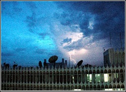
- The second monsoon spell started from July 6 though the isolated activity started from early July 5.
- The third monsoon spell can start during the mid-week of July in some parts of the country including Karachi.
When will Monsoon start over Karachi?
The monsoon generally reaches Pakistan during the first week of July while Karachi gets hit by monsoon during the second week or mid-week of July (July 15). Following are the dates of first proper rains during the monsoon season in Karachi during the last few years;
- On October 3, 2004 – The city experienced drought-like conditions, the first proper rain occurred due to Cyclone Onil that was about 35 mm.
- On September 10 and September 11, 2005 – 80 mm rain fell in a long spell of much-awaited rains. Before the rain, drought-like conditions were observed in Karachi during the monsoon.
- On July 30, 2006 – 22 mm was recorded however on August 17, 56 mm rain was recorded which was the first torrential rain after 2003.
-
On June 21, 2007 – About 40 mm (unconfirmed) rain was recorded while on June 23 a strong windstorm (111 km/h) followed by rain (17 mm), rains continued till June 25 due to Cyclone Yemyin. On June 30, 43/45 mm rain fell with strong gusty winds. On August 10 and August 11, 191 mm rain was recorded in Karachi. On August 22, 81 mm rain was recorded in the metropolis.
-
On July 29, 2008 – Proper monsoon rains started from July 29 as 50 mm rain was recorded.
-
On July 18, 2009 – 205 mm rain fell in the metropolis in just 24 hours. On August 31, 147 mm rain was recorded in the city.
-
On June 6 and June 7, 2010 – Karachi got 152 mm rain due to Cyclone Phet. The city experienced an active monsoon season from the first week of July till second week of September.
- On September 11 and September 12, 2011 – The first proper monsoon rain occurred on September 11 till September 12, a total of 140 mm rain was recorded in the city, it was the part of the ongoing flooding rain in Sindh. On July 26, 7 mm rain was recorded, rains also occurred in August.
- On September 5 and September 6, 2012 – The city was experiencing drought-like conditions however on those days 41 mm and 65 mm rain fell respectively.
- On June 13, 2013 – 22 mm rain was recorded in Karachi.
Active rains bring floods India – Rivers flowing high in Pakistan!
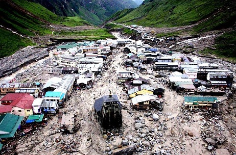
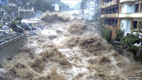
Early monsoon rains have brought devastating floods in India as the rains were 375% above normal in Uttarakhand state of India while heaviest in 22 years. It is common to see eastern and western weather fronts colliding with each other during the monsoon season that causes cloudburst in some case. Such pattern was responsible for the Indian floods where already the rivers were flowing at high level.
Normally a strong winter season means a weaker summer but the summer of 2013 was little different, high temperatures on a wide scale were observed in Pakistan and adjoining India that continued even in June. The above situation has caused the thick snow cover over the northern areas of both the country to melt at a faster rate thus increasing the river flow. Even before the rains in June in Pakistan, the Khyber Pakhtunkhwa province witnessed mild river floods that sub-merged nearby houses and buildings, 16 people lost their lives in the province due to rapid increase in river flow.
Is Monsoon tackling all odds?
As compared to last year in which there was a fear of ‘total collapse’ of monsoon (Repeat of 2009’s monsoon), this year the threat of deficient rains is minimum as compared to last year. The only obstacle in the way of this year’s monsoon remains the negative Indian ocean dipole which can develop during the middle of the monsoon season which can cause decrease in rain activity from mid-week of July till August, a common fear shared by the American, Australian, Japanese and south Korean Weather Agencies.
The World Meteorological Organization (WMO) has said that neutral conditions would prevail in the Pacific ocean however the above weather agencies have said that there is a 65% probability of formation of La-Nina later in the season which will decrease the effects of negative Indian ocean dipole in the month of September, this can only happen if both of these phenomenons form on their expected time.
Our View on the upcoming season
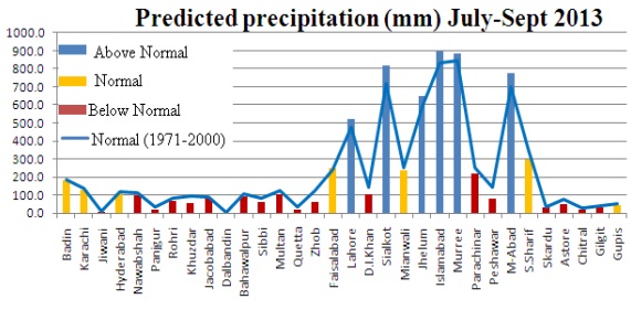
Pakistan Weather Portal (PWP)’s monsoon forecast that was issued on May 6 and was revised on June 6, following is the forecast of PWP;
“Monsoon 2013 would set in early this year in India due to the formation of a low pressures in Bay of Bengal, Monsoon will be very active in the month of June as there is a possibility of pre-monsoon in Sindh and Punjab, moderate to heavy downpour can occur in Punjab (including Lahore) and Sindh (including Karachi) during the late midweek and last week of June due to the weak Madden-Julian Oscillation (MJO) wave. Eastern & western winds interaction possible during this period of June and later in the season in upper areas of Pakistan which could lead to heavy rainfall over Khyber Pakhtunkhwa as well. Monsoon onset in Pakistan can take place in the last weeks of June/first week of July especially in the northern areas of the country. Pakistan can experience near to normal rainfall in June till early July on the wider-scale while normal to below normal rainfall after mid-week of July till August as a whole. North-eastern Punjab and Azad Kashmir can witness some frequent heavy downpour in the month of July. Due to the high possibility of the formation of negative Indian ocean Dipole, rain activity could be significantly hampered from mid-week of July and August, a partial effect of weak La-Nina might be observable later in the monsoon season (which could weaken the effect of -IOD in September). However an event of isolated flash flooding/urban flooding (happens every year) can never be ruled out.”
Monsoon Special articles for 2013
You can read special monsoon article by Pakistan Weather Portal (PWP), here;
- Another Monsoon brewing for the same Sub-continent! – Part I
- Do we really need a monsoon season? – Part II
- Pakistan bakes in Oven: Bricks for Monsoon 2013 placed! – Part III
- Look back at Past: Pre-Monsoon rains are just around the corner? – Part IV
- Monsoon facing the biggest challenge from its own Ocean! – Part V
- Road map for ‘Monsoonistan’ laid: Rains move into Pakistan! – Part VI
